A project from artist Cristina Iglesias (see a post of some of her previous work here) again dives into the idea of hidden hydrology, this time in New York City. Entitled Landscape and Memory (referencing the title of one of my favorite books by Simon Schama), the work unearths a buried stream in Madison Square Park.
From The Architect’s Newspaper: “Manhattan is crisscrossed by streams and rivers that have since been buried but continue to flow, flooding their banks and the basements above when it rains. For Landscape and Memory, Iglesias will exhume an impression of Cedar Creek, which once flowed beneath where the park now stands today.”
From the Madison Square Park Conservancy, some more info: “Nodding to historian Simon Schama’s major 1995 volume of the same name, which surveyed the history of landscape across time and terrain, Landscape and Memory is informed by Iglesias’ research into the history of the site. For the project, Iglesias located and studied antique maps that documented the water flow beneath Madison Square Park, where the Cedar Creek and Minetta Brook once coursed for two miles before flowing into the Hudson River. With nineteenth-century industrialization, streams like the Cedar and Minetta were buried underground to create additional land for building sites, underground drains, or sewers. Through Landscape and Memory, Iglesias renders this buried history visible again, inviting viewers to contemplate centuries of transformation of urban sites that were once natural.”
Excited to hear more about this and see more images, as the sketch is a bit… sketchy. You can check out the full press release here for more info. Based on some of her previous work it will be wonderful in execution. The work will be installed from May 23, 2022, through December 4, 2022 so those in New York City go check it out and report back.
I feel like I’ve been overcomplicating my explanations of the connections of climate change and hidden hydrology and Sanderson just nailed the concept in a few words. While the explanation is simple, the complex interactions between that hidden (buried) strata beneath the surface that have been erased from our urban areas and how these areas are poised to re-emerge in the urban sphere in dangerous ways as zones of flooding during extreme weather events is a topic worthy of more examination.
We have plenty of extreme events and flooding here in the Pacific Northwest to see this phenomenon play out in similar ways, causing water levels to rise in creeks or streams, or with high-precipitation rainfall that accumulates faster than it can drain in cities. Hurricanes, however, seem to be a special case in exacerbating issues just by the sheer scale and concentration of impacts in a short duration. These continual, cyclical events along the Eastern Seaboard ad Gulf Coast highlight the danger or urban flooding and as Sanderson points out, offers clear connections with the current flood events in locations of historical, now buried, waterways.
Hurricane Sandy opened many eyes to the risks. At the time there were a number of articles that caught my eye, particularly the idea that inundation and flooding at the margins were related to the idea of land filling and shoreline creation and the margins, replacing natural shorelines with hardened urban edges and bringing development out into these areas. In this June 2013 article in the Daily Mail, “How Hurricane Sandy flooded New York back to its 17th century shape as it inundated 400 years of reclaimed land.” the .
Expanded Shoreline of Manhattan from 1650-1980 – via Daily Mail
Looking at the extent of flooding in Hurricane Sandy (map below) and a number of studies on flood risk, it’s possible to do a quick mental overlay ad show the vulnerability related to the ‘made land’.
This is obviously not unique to New York City, and I’m interested in researching other places where flooding and made land has a similar correlation. In these cases, the conceptual connection started to take shape in the impacts of flooding at the edges, and how filled land can become a marker for shoreline flooding, which will inevitably be impacted more by sea-level rise in cities that have claimed1 this land from their adjacent water bodies.
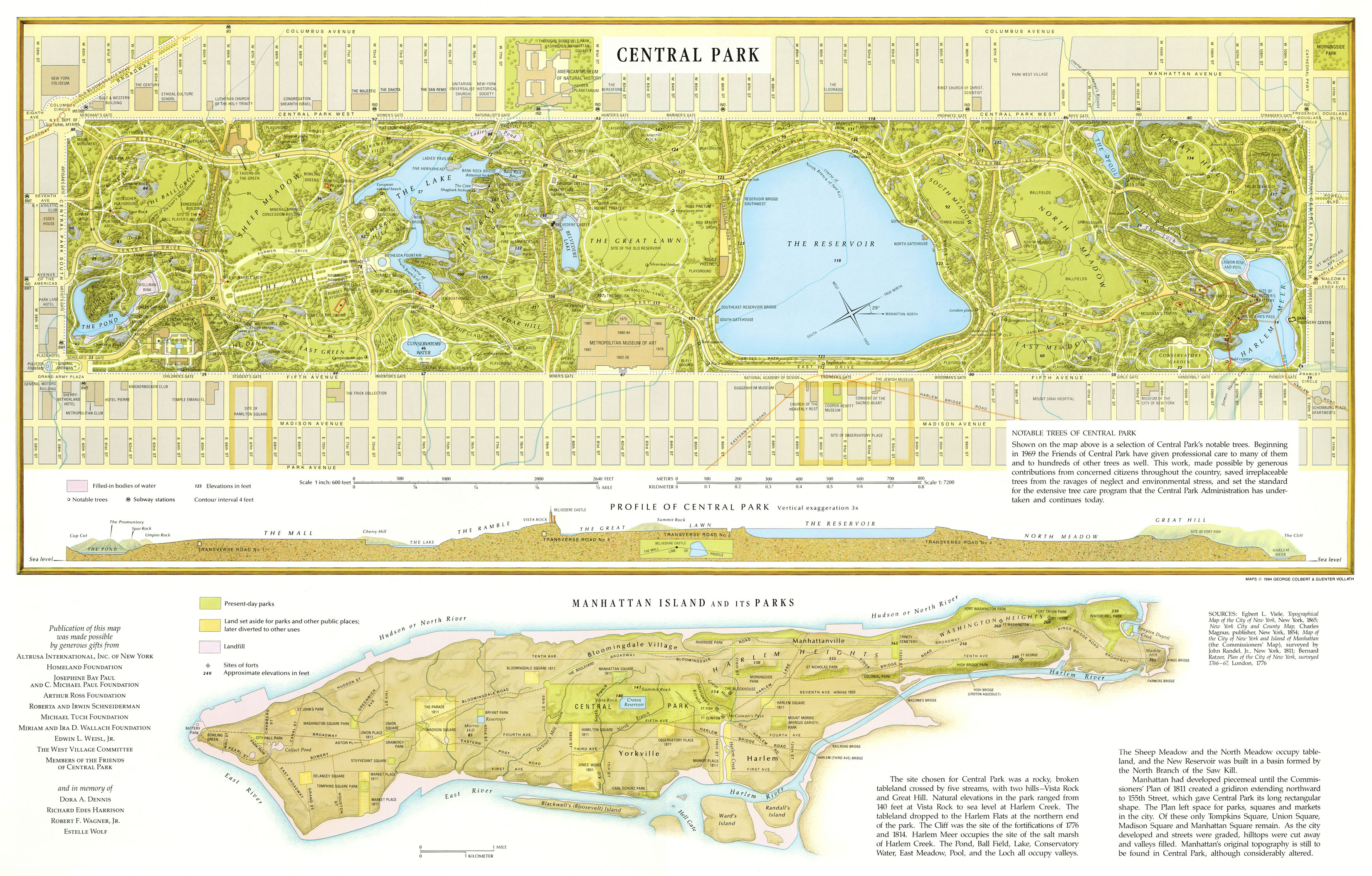
The most recent events, during Hurricane Ida, Sanderson points out, go even more fine grain to individual inland areas where historic creeks or wetlands intersect with, such as Central Park (where wetlands were removed in construction of the park) and various other areas, including fatal incidents of basement flooding, in areas of where creeks, streams, wetlands and tideflats existed even up the the early 1900s.
A specific example of flash flooding in the subway in Manhattan at 28th Street and 7th Avenue (see video on Twitter post which is bonkers for both the intensity of the flooding and the utter lack of reaction from New Yorkers watching on the platform). As the article mentions the location of the flooding: “Right in the middle of a wetland clearly shown on 18th-century maps, the headwaters for The Old Wreck, a stream that fed Sunfish Pond, on the south side of Murray Hill, before reaching the sea at Kip’s Bay.”
18th Century Map showing location of wetland in area of 28th Street Station – via NY Times
The takeaway of cause and effect is summed up by Sanderson:
“The city even has a map where the extreme flooding happens, compiled from 311 reports and official observations. It is, for all intents and purposes, a map of the old streams.”
The action here is simple – avoid damage and loss of life from these events, because they are not going to stop any time soon. Increase resilience (both social and eco/hydrological) helps, and as the OpEd mentions, there are many other socio-economic factors involved that increase risk. But Sanderson looks for solutions (the old ways of knowledge) and points out “The losses are mainly the result of our inability to read the landscape where we live and conceive fully what it means to live there. We need to see the landscape in new, by which I mean old, terms.”
Where we location development must respect the hydrological history, as we’ve seen time and time again our inability to overpower nature, and ultimately the failure of forgetting what we buried. Worth a read for the article is a great explication of a terribly absent land consciousness and ethic, but at a practical level, there are some hints that allow us to connect historical ecology to solutions such as making room for water and using Nature based solutions such as wetland restoration and tree planting, many of which are continuing to take a rightful place in climate and resilience plans.
Perhaps the ending, again, for all of our complex machinations, allows us to think more simply about the solution and find opportunities for this simple action:
“Let’s let the streams run free.”
Endnotes
Maybe my own rant, but there’s a whole series of posts and discuss related to the concept of ‘reclaiming’ land from the sea, which is the common parlance in this case. I do prefer ‘claiming’ and the idea of ‘made land’, as it’s really impossible to reclaim something you never possessed in the first place.
Header image – NY Times – photo by Anthony Behar/Sipa – Associated Press
The New York Times did a recent story on How the Ice Age Shaped New York with a tagline “Long ago, the region lay under an ice sheet thousands of feet thick. It terminated abruptly in what are now the boroughs, leaving the city with a unique landscape.” This resonated with me and reminded me of posts about Minnesota’s Lake Agassiz, as well as the Waterlines presentation last year by Dr. Stan Chernicoff on Seattle’s own geological history and how the ice age covered the city with a deep layer of ice ground away over time and as it melted 10-20,000 years ago, influenced and left many traces on cities.
New York City experienced similar issues, with a two-mile thick ice layer forming over two million years back, covering the area region encompassing much of the city and all of Manhattan, with the terminal moraine reaching the zone bisecting parts of Staten Island and Long Island, until warming and retreat 18,000 years ago.
The story of many areas is the same, the depth and weight of ice shifting bedrock, and creating waterways, kettle ponds and lakes, as well as retreat leaving glacial erratics and other rubble strewn through the zones. However it’s more distinct in New York City, as pointed out in the article: “While the line of glacial debris across the northern United States is often poorly delineated, the hilly ridge around New York City tends to be quite prominent. Its maximum height is roughly 200 feet, about that of a tall apartment building.”
The ridges and hills determined where people settled, as they avoided these areas and found flatter ground, and I remember the specific outcrops left in place in Central Park as features, but perhaps also to avoid having to blast or remove them. (see header image above) The article mentions that many place names are derived from this rises, appended with Hills, Heights, and Slope and also its usage in local building materials. The proximity of the terminal moraine to New York City is unique, but that glacial history has been forgotten over time. As mentioned:
“Despite the ridge’s prominence and early allure for scientists, it turned out to be no rival for skyscrapers and urban distractions. The moraine that shaped the city was all but forgotten. “Clearly, it’s not on the radar,” said David E. Seidemann, a professor of geology at Brooklyn College. “The educational system here doesn’t emphasize earth science. And there’s so much else to do. I’ll go to a Yankees game over geology any day.”
But the hidden remnants paint a fascinating picture, capture by geologist and environmental educator from the American Museum of Natural History, Sidney Horenstein, who also does tours of these phenomena. He found documents showing that geologists working in the 1800s found in terms of the variation of hill to flatland geology: “Ridges, mountains and even flatlands are typically rooted in rocky strata, such as the bedrock that underlies Manhattan and makes it ideal for erecting skyscrapers. But early investigators found the hilly ridges to be composed of clay, silt, sand, pebbles, cobbles and boulders, all jumbled up together.”
The walk through reports (such as the fascinating Natural History of New York published in 1842) established a chronology of more focused work on things like history of glacial floods, and fills in gaps on geological processes, even showing the emergence of terms to describe processes, like ‘Ice Age’ which was starting to be more widely used in the 1880s.
A 1902 USGS large-format map provided some spatial information as well
The maps used colors to show variations of geology amidst the emerging city grid, and identified the terminal ridge. As the article points out:
“At first, the city used the stony ridge for woodlots and rain catchments. Slowly, the uses expanded to reservoirs, recreational areas and, in time, neighborhoods in which buildings and houses were built on strong footings and foundations for stability. Today, despite the wide development of the ridge’s lower slopes, a Google Earth view of New York City — a composite of images from April, June and September — shows the glacial relic as an intermittent band of green.”
A larger image of one of the maps from the folio is seen below, via NYC99 gives an indication of the rich data available – click to enlarge (image source from Texas A&M Library).
Similar to the Missoula Floods that broke through a massive ice dam and carved out the Columbia River basin, New York also had a flood termed ‘biblical’, as glacial retreat happened around 13,000 years ago, where a “... towering wave of destruction crashed down through the Hudson gorge and proceeded to smash the southern end of the local moraine to smithereens.”
It’s interesting to draw parallels between how the glacial impacts are similar on the east and west coasts, but also how they differ due to variations of geology and topography. The hidden history isn’t just hydrology, but a combination of physical and biological processes working in tandem, over millennia. We’ve done much to erase and obscure, but traces remain, indications of these long and large processes are tucked away under our feet, waiting to attract our gaze.
“…millions of people live on or near the glacial ridge. In all, it runs for roughly 30 miles beneath New York City. Invisibly, it links three boroughs, offering mute testimony to the power of vanished ice.”
HEADER: Umpire Rock in Central Park – this and all other images, unless noted, via NY Times
My previous postscript ran somewhat longer than anticipated, due to the massive amount of work happening in and around New York City. Thus a focus on this post on the cartographic, including some of the great resources available, and the rich history of maps new and old that emerge to tell a visual story of hidden hydrology in the city and larger region. There are so many, that one who wants to dive in can jump down to the resources section below to see lots of great sites showcasing the maps, my focus here is to highlight a few I thought were interesting and beyond general map nerdiness, some that had a particular relevance to hidden hydrology.
An old version dates back to the early settlement times, from 1639 the Manatvs gelegen op de Noot [sic] Riuier (via Library of Congress) is a fun introduction to the area, north to the right showing the section of Manhattan (Manatvs) and areas surrounding. Fun to see a map from this far back, and it does represent some of the topography and hydrology in some rudimentary ways.
The 1660 Castello Plan (original and a later reproduction drawn in the early 1900s) offers a glimpse of the tip of Manhattan, or New Amsterdam.
Many maps come via The Iconography of Manhattan Island, via Wikipedia “a six volume study of the history of New York City by Isaac Newton Phelps Stokes, published between 1915 and 1928 by R. H. Dodd in New York. The work comprehensively records and documents key events of the city’s chronology from the 16th to the early 20th centuries. Among other things, it shows the evolution of the Manhattan skyline up to the time of publication” More: “Stokes’s worldwide research teams scoured public and private collections of maps, guides and obscure source material to complete his encyclopedic monument to New York City. It describes in detail the growth of a fortified Dutch settlement into a major city, and ultimately included six volumes sold to subscribers and libraries in a limited edition of 360 sets printed on Holland-made paper and 42 on Japanese vellum.”
The following plate from this Iconography is from 1693, showing Manhattan and the shift from New Amsterdam to Nouvelle Yorc:
The Bradford Map is another resource, showing “…the city of New York at the time of the granting of the Montgomery charter …” and “from an actual survey” and starting to highlight some hydrological resources like the Collect Pond. The map is a reproduction from the 1800s, but shows the area in 1730 and is similar to the later Maerschalck map, showing similar area in the 1750s.
A beautiful map is a 1777 version Plan de New-York et des Environs, showing a similar zone with a lot more detail, a precursor of some of the more detailed maps (and sophistication of mapmaking) in the late 18th century.
A larger area comes via 1766-1777 and the Plan of the city of New York in North America – surveyed in the years 1766 & 1767 by Ratzer, showing a larger zone beyond the Hudson and East Rivers.
From the header above we see the influential British Headquarters map that was used heavily in the creation of the Welikia project. This map shows the larger area of Manhattan in fine detail, with topographic relief – a zoomed in section shows why this was such an important historical document.
Fast forwarding a bit to the early 1820s, the Randel Map was an atlas of. Via The Greatest Grid website: “Between 1818 and 1820, John Randel, Jr. prepared an atlas of 92 watercolor maps that vividly illustrates the properties, old roads, and major features of pre-grid Manhattan as well as the future location of the new streets and avenues of the 1811 grid. Drawn at a scale of 100 feet to 1 inch, the Randel Farm Maps provide a detailed picture of Manhattan before its transformation. Hand drawn and colored, they are among the most significant documents in the history of New York as well as a rarity in American urban history, as no comparable maps exist for other early-19th-century American cities”. There are 92 individual maps, but an online map stitches them together in a beautifully detailed composite here.
The maps got more broad, with titles to fit like “Topographical map of the city and county of New-York, and the adjacent country : with views in the border of the principal buildings, and interesting scenery of the island.” from 1836 showing the entire island of Manhattan with relief,
The detail is amazing, and it’s available as a high-res download at multiple sources, including Wikipedia which describes it as such: “…survey of the original streams, marshes and coastline of New York City, superimposed over the street grid. The map is still used by modern geotechnical engineers, structural engineers and planners to design the foundations of new buildings and structures in the city.” A few close ups illustrate this point, and allow for georeferencing to the modern city:
A few other maps that caught my eye, specific to Hidden Hydrology Broadside of the Collect Pond, New York and Steam Boat (Five Points) highlights that the pond was still there in 1846 (or at least as represented here from 1793).
And the birdseye perspectives are another great resource, showing a different viewpoint. As a tool to communicate place, I’ve always been fascinated by these, such as this 1870 version from Currier & Ives (source unknown as I got this via Twitter) but I believe it’s from Library of Congress.
And some map-objects and infrastructure systems that are fascinating, including this one, a ” Sketch showing the ground under carriageway at intersection of Wall, Broad, and Nassau Streets : as occupied by water, gas, steam, pneumatic, cable and electric pipes, sewers, basins, culverts and vaults to houses, etc., February 1885″
There’s also a wealth of maps covering many Boroughs, but these map be for another time – and the resources below offer lots of chances for locals or the curious to dive in to more depth.
INTERACTIVE MAPS
There’s great interactive maps like the interactive to quirky side, there’s a fun historical Spyglass Map, showing the New York City of 1836 vs. today, The Smithsonian, had David Rumsey provide some discussion of this map to go along with an article about it, where: “Rumsey looks to the map’s delicate shading to tell much of its story, noting that the heavily shaded areas represent the most densely populated portions of the city at the time of the ma’s drawing. “Pretty much everything past 14th St. is country,” he explains, adding that much of what is considered Manhattan today wasn’t yet settled. In addition to the population shading, the hills of Manhattan are shown by hachures, an antiquated method of showing relief on drawn maps. “A lot of the history of Manhattan is the destruction of its hills,” Rumsey says. “Basically that topography was obliterated, except for Central Park.”
And a fun but perhaps limited in usefulness ‘Urban Scratchoff’, which does a similar thing with by revealing a 1924 map underlay. I feel as if I keep scratching but never really win anything.
MAP RESOURCES
A great site focused on Manhattan that filled in much of the above content is the map page of Manhattan Past which is connected to the site and book ‘Street Names Past & Present’ focused on the place name origins of area around the City. The maps are broken down chronologically back into the 1600s, with links to originals and some brief text, a great primer for delving into the larger pool.
Additionally, The Greatest Grid is a site that emerged from the exhibition The Greatest Grid: The Master Plan of Manhattan 1811-2011, at Museum of the City of New York in 2011 to 2012, which “documents the creation of Manhattan’s signature grid, which set a remarkably flexible framework for growth as a town of 100,000 in 1811 became today’s world city of 1.8 million people (in Manhattan only). Balancing order and freedom, uniformity and individuality, the grid continues to serve as a model of urban planning in the 21st century.” Some great background on the development of the city and the grid, as well as great maps, are found within.
The resources available are amazing, drawing on local and international institutions – one of the best being the Open Access maps from the New York Public Library, where the The Lionel Pincus & Princess Firyal Map Division has over 20,000 free, high resolution downloads available, many of the maps above coming from this source, and their active Twitter feed @NYPLMaps showcases many more.
Plan of the town of Brooklyn and part of Long Island – 1767 (NYPL)
And speaking of other non-historic maps, not specific to hidden hydrology, I’d be remiss without mentioning the New York version of Rebecca Solnit’s atlas collection Nonstop Metropolis, A New York City Atlas, authored with Joshua Jelly-Schapiro and true to form with the other regional versions from San Francisco and New Orleans, is part of the compendium of maps as storytelling devices. Read this great long essay via Public Books entitled Visible Cities by Laura Yoder for where she dives into “maps that catalogue social and cultural complexity, and teach us to engage with difference in productive and generous ways.” Another good review via Hyperallergic, “Creating an Atlas of Overlooked Cartography for New York City” where they relate that “Every map is an intense act of creative collaboration, with essays and illustrations in Nonstop Metropolis from over 30 artists and writers.” The image below is indicative of this style, showcasing “Wildlife”
For modern mapmakers, there’s a rich collection of resources, including NYCityMap and OASIS both displaying tons of thematic info on current conditions in the city, the latter even providing a historical slider showing the Mannahatta layering.
I could post maps and larger stories of hidden hydrology every day for a year and not run out of interesting tidbits here in the Big Apple, which reflects the richness of historical context and also the passion for many people to investigate their hidden hydrological histories. And it seems a fitting segue to where we are heading. Next up, we head over the pond to the undisputed champion of Lost Rivers – London.
Stay tuned.
HEADER: Facsimile of the unpublished 1782 British head quarters coloured manuscript map of New York & environs – via David Rumsey
A follow-up to the previous post allows for a bit more expansion on the fundamental sources for New York City. This includes the Welikia Project and it’s beginnings as Mannahatta, as well as the comprehensive book by Sergey Kadinsky on the Hidden Waters of New York City. We delved deep with Steve Duncan’s sewer explorations and blog Watercourses and Undercity, Together these make up a solid fundamental base of hidden hydrology work in New York City. This also complements some of the projects I’ve covered, including the project Calling Thunder, which evoked the power of historical ecology via animation, the explorations around hidden infrastructure of photographer Stanley Greenberg, and some of the walks and installations focused on hidden streams with artist Stacey Levy.
That said, there’s still much more, so a postscript is in order to provide a bit of additional context to even claim to be a passable (although not even close to comprehensive) review of some of the city, with a focus on including some tours, art, history, and more.
SOME TOURS
One aspect of any place is explorations, and there is no shortage of tours around hydrology in New York City. The group NYC H2O is a great resource for this, with a mission “…to inspire and educate New Yorkers of all ages to learn about, enjoy and protect their city’s local water ecology.” They’ve hosted some great events in the past year alone, including tours with Steve Duncan, Sergey Kadinsky, and artist Stacey Levy as well as many others. City as a Living Laboratory (evolved out of the work of artist Mary Miss) also provides some great events, include walks, such as this one exploring the past and future of Tibbetts Brook with Eric Sanderson and others.
There are some less formal characters as well, like local activist Mitch Waxman, featured here in a NY Times article from June 2012, “Your Guide to a Tour of Decay”. The article shows how he discovers, teaches and advocates about the hidden history of Newtown Creek in Queens, where, as quoted in the article: ““You have these buried secrets,” he said, explaining the thinking behind the occult conceit. He’s spotted early-19th-century terra-cotta pipes protruding from bulkheads, antique masonry sewers connected to who knows what. He added: “There really is no telling what’s in the ground there.”
And, for a somewhat related example, there’s always the amazing precedent of Safari 7, a self-guided subway based audio tour and map that highlighted “…urban wildlife along New York City’s 7 subway line”. A map of the guide is found below.
SOME ART
In terms of some hidden hydrology based art installations, there are many that span permanent to ephemeral. In the site specific realm, is Collect Pond Park, which was located in Manhattan historically as “…a large, sixty-foot deep pool fed by an underground spring” that was filled in the early 1800s. A post here by Kadinsky & Kevin Walsh on Forgotten New York discusses the project and includes this rendering that highlights the interpretation of previous pond in the design of the new park. This includes a “…footbridge spanning the pond’s waist hearkens to the original pond’s shape, providing a historical link to a pond that has had such a huge role in the city’s history, before and after its burial.”
Another site is a fountain at Albert Capsouto Park, which references some hidden hydrology. From the Parks website: “The centerpiece of Capsouto Park is a 114-foot long sculptural fountain by SoHo artist Elyn Zimmerman. This fountain bisects the interior space. Water spills from an 8-foot tower into a series of stepped “locks” evoking the canal that once flowed along the Canal Street. A sunning lawn rises up to meet the fountain from the south and granite seat walls adorn the fountain to the north.”
Capsouto Park Water Feature, 2009 – Elyn Zimmerman & Gail Wittwer-Laird
We discussed previously some of the hidden hydrology art of Stacey Levy, which was the tip of the iceberg of vibrant art scene in NYC interpreting hydrology as the medium. One larger effort worth noting is Works on Water, which is “…an organization and triennial exhibition dedicated to artworks, theatrical performances, conversations, workshops and site-specific experiences that explore diverse artistic investigation of water in the urban environment.” Their mission statement by the team sums up the potential:
“New York City has 520 miles of coastline. Its waterways are often referred to as “The Sixth Borough”. We are artists and curators dedicated to working with water to bring new awareness to the public of the issues and conditions that impact their environment through art.”
The sum of work there is worthy of it’s own future post. In the interim, a few of the key contributors to Works on Water have their own complementary endeavors, such as Liquid City, a water based project by artist Eve Mosher, a self proclaimed “…water geek, urban enthusiast and playworker in training”, whom is “…fascinated by our waterways, the space they inhabit the roles they play in our daily life and finding ways to create a greater engagement across disciplines and a greater awareness in the public narrative.”
Liquid City: Currents (Eve Mosher)
Her project aims to be the following “1. A research database of collected resources and video stories of people working on the urban waterways. An open source compendium for creative inspiration, 2. An interdisciplinary floating think tank/lab working on creative interventions about the urban waterways, and 3. A traveling think tank/lab sharing resources, traveling the Great Loop’s urban waterways.” A fascinating work on her site is the Waterways System Map below (click the link for the fully interactive version) which involves “mapping the existing system of the waterways” in extraordinary detail.
Below is another of Mosher’s project, from exhibit: “As part of Works on Water, I collaborated with Clarinda Mac Low to create a large scale floor painting of the NY waterways. Intended to ground people in the specific site of water as material within the exhibition, the waterways acted as a guide into the exhibition space. Overlaid on the waterways was a video in which I represented the historic waterways and Clarinda imagined the future…”
A different project led by Kira Appelhans, adjunct assistant professor, Integrated Design Curriculum, Parsons The New School and Richard Karty, postdoctoral fellow in Environmental Studies, from 2011 is entitled Waterlogged. The endeavor “…explores the process of mark-making in the landscape from glacial to hydrologic to human. We will examine the existence of remnant waterways and their relationship to the city’s organizational patterns and forms. Using printmaking, restoration ecology, public space design we will explore the ecological impact of the intersection of historic waterways and urban infrastructure.” The diverse artworks are captured in a video as well as a booklet ‘Remnant Waterways‘ (pdf) which showcases the work of students, including prints inspired by buried streams.
Iteration 3 – Eve Neves
Print by Mikaela Kvan
In the realm of photography, the work of Stanley Greenberg and Steve Duncan show two sides of underground New York City, and photographer Nathan Kensinger, who investigates “The Abandoned & Industrial Edges of New York City” shows a third. He has an ongoing series entitled “New York’s Forgotten Rivers” where he has been documenting “New York City’s last remaining aboveground rivers and streams, in all five boroughs.” An image below shows one of these photos.
Another recent exhibition “To Quench the Thirst of New Yorkers: The Croton Aqueduct at 175” that just completed it’s run at the Museum of the City of New York, offers a similar theme, with the tag line: “Uncover the hidden history of New York’s original water source, buried beneath the city”, it features “…newly commissioned photographs by Nathan Kensinger, tracing the aqueduct’s route and revisiting sights that Tower had sketched nearly two centuries before.”
Shifting from the visual to the literary, I previous mentioned the great Robert Frost poem covered in Hidden Waters blog, focused on Minetta Creek. Another literary reference worth a look is this 1998 poem by Jim Lampos “Gowanus Canal” about the partially hidden and very polluted waterway in Brooklyn. The whole thing is worth a perusal in detail, but I was struck by this passage, which evokes some of the history of place so acutely:
“I’ve come with a notion Old Gowanus, to recollect the splinters of dreams and severed fingers you’ve tucked away, the stolen pistols and sunken treasures you’ve saved the piss, tears dreams and sweat you’ve claimed. Recollect–shitty Canal stinking to the heavens– that you were once a river and hills rose from both your banks. Brooklyn Heights nourished you as it returned your borrowed waters sweetened with the blood of revolution. A city was built all around you– a city of pizza parlors, churches and Whitman. A city of pigeons, ice factories and hit men.”
SOME HISTORY
Tons of possibilities to cover in the history genre, as New York City has a million stories, In picking a few, I decided to focus on the ones that rose to the top due to their sheer uniqueness. The one that was amazing to read about comes via Geoff Manaugh at BLDGBLOG, referencing a complicated series of posts about Fishing in the Basements of Manhattan that goes back to the NY Times blog ‘The Empire Zone’ and eventually a post link to a comment from 1971 Letter to the Editor, which mentions this potentially tall tale:
“”…We had a lantern to pierce the cellar darkness and fifteen feet below I clearly saw the stream bubbling and pushing about, five feet wide and up-on its either side, dark green mossed rocks. This lively riverlet was revealed to us exactly as it must have appeared to a Manhattan Indian many years ago. With plum-bob and line, I cast in and found the stream to be over six feet deep. The spray splashed up-wards from time to time and standing on the basement floor, I felt its tingling coolness. One day I was curious enough to try my hand at fishing. I had an old-fashioned dropline and baited a hook with a piece of sperm-candle. I jiggled the hook for about five minutes and then felt a teasing nibble. Deep in the basement of an ancient tenement on Second Avenue in the heart of midtown New York City, I was fishing. Feeling a tug, I hauled up in excitement and there was a carp skipping before me, an almost three pounder. I was brave enough to have it pan-broiled and buttered in our upstairs kitchen and shared it with my brother…”
Going way back, a few folks referenced what seems an interesting resource, “Springs and Wells of Manhattan and the Bronx, New York City: At the End of the Nineteenth Century” by James Reuel Smith, in 1938, in which“…he reflects on the rapidly changing city and on the practical and aesthetic pleasures offered by the remaining springs: “In the days, not so very long ago, when nearly all the railroad mileage of the metropolis was to be found on the lower half of the Island, nothing was more cheering to the thirsty city tourist afoot or awheel than to discover a natural spring of clear cold water, and nothing quite so refreshing as a draught of it.”
James Reuel Smith. Unidentified woman drinking at Carman Spring, on W. 175th Street east of Amsterdam Avenue, New York City. undated [c. 1897-1902]. Glass plate negative. New-York Historical Society.
Other short reads include Thomas J. Campanella’s essay in Terrain.org, “The Lost Creek”, and a great article connecting west to east worth from Nathan Kensinger, “What Can NYC Learn from San Francisco’s Last Wild Creeks?” where he looks at Islais Creek (and of course includes some amazing photos) as a model for how aboveground creeks can be a model. He summarizes: “Flowing through an increasingly gentrified city,…this historic stream offers up a refreshingly untamed landscape. Though it travels just five miles from its headwaters in Glen Canyon to its mouth in the San Francisco Bay, and is bisected by a three mile underground segment, Islais Creek provides critical support to two radically different natural environments, both of which are currently undergoing extensive renovations. It also illustrates several approaches to urban planning that are unfamiliar to most New York City waterways.”
Islais Creek – photo by Nathan Kensiger, via Curbed NY
SOME MISCELLANY
With any discussion of hidden hydrology, the concept of daylighting always emerges as certain projects seem to lend themselves to this approach. A presentation by Steve Duncan is worth a read as it covers this topic in depth, and the project with the most traction is Tibbets Brook, in the Bronx. Located in Van Cortland Park, the daylighting push garnered a fair amount of press (here, here) and also a petition, with a detailed coverage in Untapped Cities from 2016 which shows an image from a report “Daylight Tibbetts Brook” (PDF file – from Siteation). A figure from the report shown below identifies a potential route of the daylighted creek.
Before and After views of daylighted creek
Another final item worth discussing, albeit removed from hidden hydrology explcitly, is the image of climate change on the city. We cover this in the context of modern New York via Kim Stanley Robinson’s New York: 2140, which imagines a flooded, post-catastrophe New York with, a narrative of New York as a “SuperVenice”, rife with political upheaval, class warfare, and and salvage operations referencing historic maps — setting the stage for a new geography that is equally fantastical and plausible. As mentioned in the New Yorker:
“Another narrator—a nameless urban historian—tells the story of New York from a bohemian point of view. America’s boring losers all moved to Denver, he says, and so the cool kids took over the coasts. “Squatters. The dispossessed. The water rats. Denizens of the deep, citizens of the shallows.” The abandoned city becomes an experimental zone—a place where social innovation (“submarine technoculture,” “art-not-work,” “amphibiguity”) flourishes alongside “free open universities, free trade schools, and free art schools. Not uncommonly all of these experiences were being pursued in the very same building. Lower Manhattan became a veritable hotbed of theory and practice, like it always used to say it was, but this time for real. . . . Possibly New York had never yet been this interesting.”
The connections between this fictionalization and the changing climate that could lead to more frequent flood events, seems a timely connection between history (past) and what it means now and into our our future. The story told by Robinson may be a bit lacking in places, but the details and context is compelling.
The vision of a flooded city in “New York 2140,” a science-fiction novel by Kim Stanley Robinson, is surprisingly utopian. via New Yorker
As you can see, there are literally hundreds of links for particular creeks, art, history, explorations, tours, and other discussions around New York City. My original goal was to also include maps in this post, but as you can see it’s already bursting at the seams, so I will conclude New York with one additional post focused on the cartographic as to not overwhelm.
HEADER: Bronx River, image by Nathan Kensinger as part of his New York’s Forgotten Rivers series.
As we’ve seen in the Welikia Project and the book Hidden Waters of NYC there’s multiple ways to approach the investigation and documentation of hidden hydrology in the same city. Next is a hybrid photography, infrastructure history and adventurous drainer in the form of Steve Duncan. Since the 2010s, he’s been featured often, the theme similar to these stories from NPR “Into The Tunnels: Exploring The Underside Of NYC” as well as the New York Times (here “The Wilderness Below Your Feet” with Norwegian explorer Erling Kagge).
Duncan, here smiling after the third night camping underground, is a graduate of Columbia University and is working on his doctorate in urban history at the University of California. via NPR
His photos are featured as well in National Geographic “11 Rivers Forced Underground” which include New York as well as other cities around the world. A few of the shots:
Sunswick Creek, New York City (Photo by Duncan)
Tibbets Brook, New York City (Photo by Duncan)
River Sheaf – Sheffield, England – Photo by Duncan)
My favorite below as the idea of canoeing this hidden streams is a bucket list dream for me. This one is of the Park River in Hartford Connecticut. From the NatGeo article: “Today, a few intrepid urban explorers paddle canoes down the buried river. John Kulick of Huck Finn Adventures, who has guided float trips through the subterranean section, told the New York Times he has seen eels, carp, and stripers in the dark water. Kulick joked, perhaps at least half seriously, that a burst of water gurgled into the river because “someone flushed a toilet.”
Park River, Hartford Connecticut (Photo by Duncan)
The site Watercoursesprovides the more academic side of this inquiry, dating back to 2008-2010 with a goal of “Looking for the lost streams, kills, rivers, brooks, ponds, lakes, burns, brakes, and springs of New York City.” As much of it isn’t regularly maintained, it’s still great repository of info, maps, photos, and lots of good links. Organized into regions and sites, with a sidebar around “Named Streams, Ponds, & Springs” it’s a wealth of info to dig into and some great, NY specific info. As mentioned in the introduction:
“Almost all of the the streams, ponds, swamps, tidal inlets, flood plains, springs, etc that once dotted the fertile land seem, at first glance, to have disappeared underneath the tide of New York City’s urbanization. This is not completely true. In many cases, the city retains the imprint of these features; in the shape of a road, for example, like Water Street in lower Manhattan, that used to follow the edge of a stream or river; or sometimes just in the name of a neighborhood or street.”
Plus this great 1901 article from the NY Times on excavating the creek.
Undercity is the other side/site of Duncan with posts ranging from 1999 through a sporadic fits and an end in 2015 with a focus on the “Guerrilla History & Urban Exploration” side of things. These posts offer a great array of topics, like how 9/11 impacted urban exploration, the lives of the Mole people, and even a blurb in the difficult to reproduce on black pages local NW Design mag Arcade.
Like many websites of a certain vintage, there’s plenty of broken links (unfortunately the Explorations tab being one of them) but still lots of great info – also a gruesome shot of Duncan’s hand and after story when he slipped and sliced it open during one of his explorations. Sifting through the links, there are some really hidden gems, inlcuding a book link I’d not seen before for New York Underground: Anatomy of a City, and some great posts about England and Rome around March 2009.
My hands down favorite is this link to a Life Magazine story from November 7, 1949 on ‘Underground New York’, which featured some amazing cutaway images like this one on the complexity of subsurface infrastructure:
For some additional reading by Duncan himself, there’s a thoughtful essay on Narrative.ly from 2012 “An underground explorer discovers his city’s lost lifeblood” in which he discusses the importance of the historic streams in New York, their eventual destruction:
“With further development came the burial of Tibbetts Brook, and many of the other streams. In some cases, putting them underground was merely a way to create more buildable land above. In others, the streams that once supplied drinking water or fish were converted into sewers and drains. Today, the lineage of many of the major sewer lines in New York City can be traced back to streams and rivers that flowed unfettered for centuries and even millennia before the city matured around them. Today, their past is all but forgotten.”
He continues the essays through some exploration of Tibbetts Brook, and discussion of the Canal Street sewer, New York City’s first, discussing many of the creeks, through actually following their current form. Many of them as he mentions, are too small to explore underground, being only a few feet wide, but “it is impossible to completely parse out the old “natural” Minetta Brook, or the Tibbetts or the Sawmill, from the urban landscape and sprawl of the modern-day “Big Apple”—but that doesn’t mean they’re gone. Far from it.”
There’s also a great video by filmmaker Andrew Wonder from 2010 called UNDERCITY which follows Duncan underground.
Some great background on a pioneer in the urDuncan on Twitter @undercitysteve where he’s giving tours around the city. He’s also on FB, which i am not but probably easy to find via a search. There’s a link on Twitter to another site undercity.org but it wasn’t working for me.
HEADER IMAGE: “A self-portrait taken by Steve Duncan in New York City’s Croton Aqueduct, 2006” Photo By Steve Duncan, via NPR
Another fine resource that adds to the hidden hydrology knowledge base in New York City is Sergey Kadinsky’s Hidden Waters of New York City, which “serves as a guide to the stream by tracing their development along their courses” (xiii). The book takes a different yet complementary direction than the Welikia project and other efforts I’ve mentioned and will follow up on. Publishes in March, 2016, the book summary via Amazon provides some context: “Beneath the asphalt streets of Manhattan, creeks and streams once flowed freely. The remnants of these once-pristine waterways are all over the Big Apple, hidden in plain sight”
Kadinsky’s day job is at the New York City Parks Department, has experience as a tour guide, also teaches and contributes to Forgotten New York, all of which provides a good context for open spaces, as well as a forum for the stories of hidden and forgotten waterways of the area. As he mentions in the brief introduction:
“The city’s waterways have become a place where the public is reminded of nature’s presence in the city.” He continues mentioning specifically that inland areas, where “…waterways are not as visible, having been buried beneath the streets and concealed behind building. If one searches carefully, one can hear sounds of hidden streams churning beneath manholes and see traces of them in street names that recall a water past.” (xiii).
Covering Manhattan, The Bronx, Queens, Brooklyn, and Staten Island in different sections, the breadth of the book is it’s major take-home. Any New Yorker would be doing themselves a favor by picking up a copy and being surprised to find out that you don’t have go far to find an interesting historical place you probably didn’t know about. The short blurbs about each area come with a variety of factoids, as well as good local destinations and options for travel via bus, subway, and bike.
The content is great, albeit brief as the book covers, as mentioned on the cover, “101 Forgotten Lakes, Ponds, Creeks, and Streams”. The typical post gives a tour of the place, some history, and delves into some specific topics, for instance the early chapters on the Collect Pond, Harlem Creek, Minetta Brook, and Canal Street (all links to the blog) provide great anecdotes about infrastructure, geology, cultural history, and the forces that led to the eventual burial of these places. Some are hidden, others are brought back metaphorically or through places names, and many still remain hidden. Others are more brief, with the history of the place and some brief info suffice.
A review of the book by Eric Sanderson and Christopher Spagnoli via The Nature of Cities from November 2016 entitled “Where did all the Streams Go?” offers a bit more context on the book from folks that are admittedly more local in viewpoint. As mentioned: “Kadinsky’s descriptions of waters invoke the flow of time” and provide the following, which capture the nature of the stories held within the book:
“Perusing Hidden Waters is fun for both the armchair historian and the modern urban eco-adventurer. Without sermonizing, there is a distinct historical rhythm to these accounts. Most begin with a colonial description of a typically beautiful, formerly long-lasting, watery feature of the environment, many of which formed during the last Ice Age—that has been co-opted for industrial purposes. Nineteenth century New Yorkers largely regarded waterways as places to get power, launch vessels, and/or dispose of sewage and garbage. Once these ponds, streams, and other waters were fouled, the city government and private actors, on the hunt for more land to develop, filled and paved them, a process that played itself out in fits and starts from the late 19th century through most of the 20th century. The natural waters we have left now are largely the result of neglect—so little time, so many streams to fill—until the environmental movement of the late 20th century finally created the legal and regulatory tools to stop their destruction.”
Perhaps a case where the blog is better than the book as the “companion blog for the book ‘Hidden Waters of NYC’ provides more room and allows Kadinsky to venture beyond the format the book constrains him to both geographically and visually. For me the depth of information in the book pales in comparison and seems lacking in what Kadinsky covers in the blog, with more informal stories and visuals. As a field guide, it seems a bit too text heavy, and lacking in really good contextual maps where one could follow along and tour through the narrative in a way that allows the story to unfold. This may be more a personal preference, however, the the overlay of new/old is fundamental to engaging with this type of historical ecological information, perhaps best addressed by the compelling map visuals of the Welikia Project. Although it’s available on the blog, it is the one thing sorely missed in the book.
He also includes a two partreading list with some great additions to the local and broader context, including connections to Stanley Greenberg and others beyond the realm of water. In highlighting the book I’m aiming to showcase what i think is a great contribution, namely writing about hidden hydrology, and also to provide some thoughts about what works in curating and narrating these stories of place. It’s hard to capture in book form, the spirit of what is lost, the history of then, erasure, time and what is still there (a dilemma faced by much of the hidden hydrology literature). In the end any text that endeavors to do so needs maps, and lots of them, to support this effort.
Read the blog and follow him on Twitter @SergeyKadinsky and you’ll see more of this great example of a passion for place and hidden hydrology that connects people to their home places, Kadinsky’s book and blog aid in this. He mentions this connection in the intro, and his work helps make true that “inland waterways today have resumed their role as vital elements of the city’s identity; providers of a sense of place.”
As I mentioned, New York City and the larger metropolitan region is an important case study in hidden hydrology, with a range of interesting activities spanning urban ecology, history, open space, art, subterranean exploration, and much more. As a city with a long and vibrant history it’s not surprising that the story of water would be equally compelling. The following few posts will expand on some of the key activities that shape the hidden hydrology of the city.
Times Square then and now: the area featured a red-maple swamp frequented by beavers, wood ducks, and elk. – via the New Yorker
The publication of the ideas with the publication of the Mannahatta book (originally out in 2009 and with new printing in 2013) and this broader work by Eric Sanderson (and his very well loved TED Talk) and crew on visualizing and creating rich data landscapes for Manhattan and the larger region is constantly compelling, and the shift to a broader scope under the name The Welikia Project in 2010 was really exciting to see.
The Welikia Projectexpands the provides a rich and well documented study of the historical and ecological study of New York City dating back over 400 years and inclusive of a range of interpretation from art, ecology, and design. The overview of Welikia here provides a much longer and more complete synopsis of the project, but I’ll pick some of the interesting ideas I think are worth of discussion in information larger ideas about hidden hydrology.
The main page offers a range of options that the project provides. Per the overview page, “The Welikia Project (2010 – 2013) goes beyond Mannahatta to encompass the entire city, discover its original ecology and compare it what we have today… The Welikia Project embraces the Bronx, Queens, Brooklyn, Staten Island and the waters in-between, while still serving up all we have learned about Mannahatta. Welikia provides the basis for all the people of New York to appreciate, conserve and re-invigorate the natural heritage of their city not matter which borough they live in.”
Tools include some downloads include curriculum for teachers to use, and some publications and data also available which would be fun to explore more. A few notable bits of info worth exploration is this page “How to Build a Forgotten Landscape from the Ground Up”, which is a nice overview of the methodology used by the Welikia team, and provides a nice blueprint for organization of data that is transferable to any locale.
The original historical 1782 British Headquarters map was the genesis of any number of overlays that, once digitized into GIS, provided a historic base to layer additional information from other sources, along with inferences by professional ecologists and other members of the team. These were also able to be georeferenced, which allows for the overlay of historic to modern geography, which becomes the basis for some of the larger interactive mapping we’ll see a bit later. A map series from the Welikia site demonstrates the layering and aggregation possible.
Welikia Map Explorer – Lots of interesting background that I’ve literally barely scratched the surface of. As I mentioned, the beauty of Mannahatta was the visualization of the historic surface, and through mapping with georeferenced location, provided an easy opportunity to create overlay maps of historic and modern. The key part of this project is the Welikia Map Explorer, which offers a simple interface that can unlock tons of information. Starting out, you have a full panned out view of the 1609 map visualization for Manhattan.
By selecting an address or zooming, you can isolate locations or just navigate. It’s got that same video game quality I mentioned in my recent post about the DC Water Atlas, with some exploratory zooming and flying around the landscape looking at the creeks, wetlands and other area, you half expect to click and launch some next part of a non-linear exploration game. The detail is amazing, and the juxtaposition between the very urban metropolis of New York City with this lush, pre-development landscape is striking both in plan, as well as some of the 3D renderings above.
You can then select any block and it will pop up a box that allows you to access lots of data underneath on a smaller level.
The interface provides layers of site specific data, and breaks down items like Wildlife, potential presence of Lenape (original native inhabitants, and Landscape Metrics. “Welcome to a wild place: this block in 1609! Through the tabs below, discover the wildlife, Native American use, and landscape factors of this block’s original ecology, as reconstructed by the Mannahatta Project. You can also explore the block today and sponsor the Mannahatta Project into the future.”
The Modern Day tab relates back to OASIS maps of the modern condition, making the connection of specific places easy to discern. “Landscapes never disappear, they just change. Click on the image below to see this block today through the New York City Open Accessible Space Information System (OASIS) and learn about open space and other contemporary environmental resources.”
For the beautiful simplicity of the map, it’s easy to lose sight of the fact that this is dense with real data and models that attempt to provide a real viewpoint to what each parcel was like 400+ years in the past. We discuss baseline conditions much in design, stormwater, ecology and habitat studies, and this level of evidence-based, site scale data is so important to decisonmaking not just in terms of former waterways, but in restoration and management of spaces. This is summed up on the site:
“An important part of the Mannahatta Project is not leaving ecology in the past, but to appreciate it in our current times, to see how we can live in ways that are compatible with wildlife and wild places and that will sustain people and planet Earth for the next 400 years.”
Visonmaker.NYC – Of the more recent expansions of this is the creation of Visionmaker NYC, which “allows the public to develop and share climate-resilient and sustainable designs for Manhattan based on rapid model estimates of the water cycle, carbon cycle, biodiversity and population. Users can vary the ecosystems, lifestyles, and climate of the city in an effort to find and publish sustainable and resilient visions of the city of the future.”
Worthy of a full post on it’s own, the idea is to emphasize the link between the Mannahatta era of 1609, the current era four centuries later, around 2009, and a future world into the future another 400 years in 2049. This gives a great opportunity to create a key linkages between historical work, current scenarios, and future conditions.
As they mention: “A vision is a representation of a part of New York City as you envison it. You select an area and can change the ecosystems – buildings, streets, and natural environments – as well as the climate and the lifestyle choices that people living in that area make.” and you can also view other published visions done by users of all ages. The interface is similar to Welikia, as it allows an overlay of layers with varying transparency for comparison.
More on this as I dive in a bit, but you can also watch a more recent 2013 TEDxLongIslandCity video shows this tool in more detail:
The mapmaking is of course pretty awesome, and they keep posting new visualizations and updates, such as this 1609 topo map, posted via Twitter via @welikiaproject on the “Preurban (year 1609) topography and elevation of #NYC”
There was also some great local quirky info, such as this map and historic photo showing perhaps the strangest remnant geological remnant in a city I’ve seen. Via Twitter from December 2016, “29 Dec 2016 “Rocky outcrops in NYC, were mostly concentrated in Manhattan and the Bronx and composed of schist and gneiss.”
You can and should also follow Sanderson via @ewsanderson , continuing his work at the Wildlife Conservation Society and to see him giving talks and tours around the City. A recent one mentioned that “After seven years of effort, he will share for the first time the digital elevation model of the pre-development topography his team has built, discuss why the climate and geology of the city together make our landscape conducive to streams and springs, give a borough by borough tour of ancient watersheds, and suggest how we can bring living water back to the stony city again.”
Sounds great, and I wish sometimes to be a bit closer to be able to experience this around these parts. Continuing to inspire beyond Mannahatta to the broader Welikia Project, Sanderson and all the crew that make it a reality is a great example anywhere in the world of what’s possible in tracing the threads between history and contemporary environmental issues. If someone today gave me a chunk of money and said do this for Portland or Seattle or both (and honestly folks, we really should) I’d jump on it in a second.
In my journeys investigating hidden hydrology I stumble upon some interesting side projects that fit nicely as a complement to the idea of buried creeks and lost rivers. While the main thrust of the project is on these lost rivers, the parallel of the unseen in terms of infrastructure systems led me to the work of photographer Stanley Greenberg. A short interview as part of Urban Omnibus series Unseen Machine entitled Stanley Greenberg: City as Organism, Only Some of it Visible piqued my interest.
The interview, which is from 2010, discusses some origins of Greenberg getting into photography, as well as the way of looking at the city in new ways.
“I think the city is a huge organism, only some of it visible, and we inhabit it, change it, get changed by it. But there is so much of it that I don’t know. I have mental maps of some neighborhoods; others I still need to explore. There are New Yorkers who never leave their home neighborhood. I try to get out and see as much as I can; walking, on my bicycle, in the subway. And I am always reading about the city, present and past. I suppose I treat it more like a tourist would, always looking for new things and hidden old things. I’ve learned to look for different kinds of subtle landmarks; where are the water tunnel shafts, for example, and how they affect a particular landscape. Or how different eras are marked by manhole covers, lampposts, width of the streets, other urban artifacts. I’m a birder, so I’ve trained myself to look at details. But it’s the same with the city; you always need to be looking. I think it’s important not to take it for granted. That’s what I try to do with my pictures; convince you that it’s worth your time to look at the city, maybe in a way you hadn’t before.”
The concepts of infrastructure also is juxtaposed with discussions of access and security of these system.
Greenberg mentions that he had good access at the time, but that the ideas have changed: “I’m saddened that so many of the places I photographed for the first two books have been removed from the public’s eye. I still think that when there’s more public access, places are safer, for a number of reasons. Neighborhoods, for example, are always safer when more people are outside and active. You can’t possibly police all sensitive locations, and you have to have the public take ownership of its property seriously. I haven’t trespassed (much) to get pictures, since my equipment doesn’t allow for it — and in most of my projects, I haven’t needed to. But I support the idea that sometimes the public’s right to know trumps rules of access.”
The photographs are, as you can see, typically black and white, and tend to focus on the architectonic, which is perhaps more about the subject than the photography itself. One interesting photo is from Fresh Kills Landfill in Staten Island, taken in 1993 before the eventual design competition and ongoing multi-phase redevelopment into Fresh Kills Park
Greenberg mentions: “I photographed Fresh Kills landfill for the book (though the pictures were not included) and then again as a commission just before the design competition started. Some places are transformed while using their history in an interesting (and often more subtle) way. Others become simulacra of what was there before, and are much weaker because of it.”
There’s also some interesting recent work on Button Agreement (a project that includes walks of Manhattan, water tunnels in NYC, and explorations of water and cities) which incorporates some earlier work on Water Log, which looks at “Water infrastructure: water supply, aqueducts, dams and dam removals, canals, locks, and other related structures and sites”
Again, the content is diverse, but includes some color photography, and delves a bit into . The photo below is from work on the “Lake Superior, Part 1″ and is captioned: “Storm Sewer (and trout stream, Duluth, Minnesota” connecting squarely to hidden hydrology.
The more subtle, comes in the form of walks (with some simple hand-sketched route maps included) following infrastructure systems, such as “City Water Tunnel No. 3 Ventilation Towers”, which has multiple shots of towers woven through the city, highlighting the subterranean path by pointing out features that would probably go unnoticed by the average urban dweller.
And closer to my neck of the woods, the photographs of the Elwha Dam removal on the Olympic Peninsula, “Elwha River, 2010-2014″ are great, showing some evolving imagery of areas as the dams were decommissioned.
Lots more exploration here, but the concept of hidden hydrology has orbits that transect the infrastructural is embodied in Greenberg’s photography. By looking deeper at cities and the subsurface elements, we can provide a beautiful connection (often even just the mundane becoming visible) to these lost, buried, hidden, yet still vital systems.
The idea of using art to express historical stream routes is a powerful and simple method for connecting people with hidden hydrology. There are many such precedents, but a recent version I thought I’d mentioned comes from environmental artist Stacy Levy, as part of a workshop at Hunter College sponsored by NYC H20. I noticed this first on the site untapped cities, and it was covered in the New York Times the following day.
Levy took folks on a tour with some bonus artistic endeavors: “On Friday afternoon, using blue chalk paint, Stacy Levy plans to palpate a few sidewalks on the Upper East Side of Manhattan to visualize the path of a stream, now out of sight, that has been running since ancient times.” She used the 1865 Viele map of Manhattan, a much documented source of hidden streams in New York, as inspiration of the flows of the walk. A snip of one of the portions of the map, and a closeup of the 1865 map (which are probably somewhat close in content but somewhat stylistically different).
1874 Viele Map – via David Rumsey
As the NY Times mentioned, “Searching for the city’s vanished waterways has become a form of specialized detective work, much of which begins with the Viele Map.” From untapped cities: “Water is one of our favorite substances, yet we know very little about its ways,” says artist Stacy Levy. She explores hidden patterns of hydrology, drainage and microscopic life forms, from tiny microorganisms to large watersheds, using art to reveal the natural processes. This event will explore Levy’s collaborations with urban nature that meld art, engineering and ecology.”
Excerpt of 1865 Viele Map – showing location of tour – via David Rumsey
There’s also a bit of history from long-time buried creek explorer (both on the surface and as a drainer down in the pipes) Steve Duncan, who has documented this at his expansive Watercourses blog. He is quoted in the NY Times: “The stream being traced made its way along the east side of Manhattan, with some of it captured in a pond in the southeast corner of Central Park, and other branches eventually flowing into the East River at 47th Street. Historical texts show that a “kissing bridge” crossed it around 50th Street, and the name of the waterway appears to have been De Voor’s Mill Stream”
“A woman who was walking by, who works on the block, alerted us to the persistent nature of the puddle,” Matt Malina, founder of NYC H2O, told us. “I also overheard a mother say to her daughter as they walked by, ‘That’s why this is the mosquito block!’”
Photo courtesy NYC H20
The mystery was solved, again quoting ThisEastSide: “The building of Manhattan paved over many primeval brooks and streams. But some, like the De Voor Mills Stream under 64th Street, just want to be free. The puddle is a spring that feeds the stream. During heavy rains, it fills nearby basements with water. (A superintendent at one of the nearby buildings told Malina that he keeps a sump pump in the basement for such occasions.)”
Photo courtesy NYC H20
Part of Levy’s tour, where “…she recently took a group of volunteers to the site of the puddles (actually, there are two) and supervised their drawing of swirls representing the turbulent water under the sidewalks.” Seen below, tour goers and passersby joined in the fun, marking swirly water flow patterns on the old path of the buried stream. In typical urban fashion, the police were called, “concerned that the group was defacing the sidewalk. Their worries were dispelled upon learning that the medium was chalk. As it happened, the weekend rains washed away most of the drawings.” As author Froma Harrop concludes, “So the E. 64th Street puddle is actually a spring feeding the De Voor Mills Stream. Henceforth, let’s call the puddle a “spring.” A lot more elegant, don’t you think?”
The chalk paint is an interesting idea to engage without permanently marking – perhaps just to avoid getting the police called on you. The recent work in chalk is a more ephemeral version of Levy’s 2004 work Streamlines, which used permanent paint, glass beans, stone and bronze to mark 400 feet of waterway along paths at the North Carolina Zoological Park, Greensboro, NC
Photo Courtesy Stacy Levy
From her site:
“The hydrological patterns of the nearby stream were enlarged and painted onto the meandering path with road striping paint. Patterns of vortices were painted where the path curved or went past a manhole cover. Parallel lines of laminar flow depicted the straight portions of the path. These amazing patterns are invisible to the eye, but present in all flowing streams.”
Photo Courtesy Stacy Levy
From Levy’s website, it looks like there are plenty more inspirations for us to tap into, including one of her projects I’ve used countless times as a precedent for project, the fantastic Ridge and Valley at the Penn State Arboretum, with a stunning etched bluestone plaza with “a 924 sq. ft. map shaped like the Spring Creek watershed” fed by rainwater.


 Many maps come via


_-_Geographicus_-_CollectPond-hutchings-1846.jpg)


 And speaking of other non-historic maps, not specific to hidden hydrology, I’d be remiss without mentioning the New York version of Rebecca Solnit’s atlas collection


