The connections between climate and hidden hydrology is a continuing theme, and inevitably will result in more examples that can be documented making the connections between present and future impacts and historical ecological systems. Each of these has a specific context, which influences the extent of impacts (urban/rural) and the hydrological dynamics (lakes, rivers, shorelines). The recent flooding in November of this year in the town of Abbotsford, which lies near the border of Washington State and British Columbia is one recent example. The connection was made via Twitter by @tornadodc (Lisa Genialle), who posted the following image of flooded highway overpass with the quote “Anyone who knows their local Fraser valley history, this used to be a lake back in the day. Before it was drained to make way for settler farming.”
I had little reference for this particular region or the Sumas Lake specifically, however was supplied with more context via the subsequent thread of responses, many of which yielded Chad Reimer’s 2018 book “Before We Lost the Lake” which explores the ‘biography’ of the lake and its ‘natural and human history’. This provided some much-needed context for what existed and how the flooding takes the shape of this lost lake.
Reimer outlines a similar story found in many locations, a waterway that had been a vital and ecological benefit to the surrounding environment and a resource to milennial of indigenous people, and was summarily ‘reclaimed’ for farmland through drainage, canalization and pumping in 1924. From the review in the Chilliwack Progress: “For thousands of years, Sumas Lake sat near the centre of local culture and life. Then, nearly 100 years ago, engineers drained Sumas Lake, built a canal to harness the Vedder River, and, in the process, radically transformed the area.” A big missing piece of the narrative also covered by Reimer’s book is the displacement of the indigenous people, who have sought compensation for the lost cultural resource, both as a place of hunting, fishing, and gathering that was eliminated when the lake was filled.
Beyond the Sumas First Nation people, the lake is forgotten by most, or at best a historical footnote. As mentioned on the publisher’s site: “Today, few people are aware that Sumas Lake ever existed. The only reminder is a plaque erected on the old lakeshore, at a rest-stop along the Trans-Canada Highway just east of Whatcom Road, on the historic trail blazed to BC’s gold fields. Yet for millenniums, Sumas Lake was a dynamic, integral part of the region’s natural and human landscape.”
The narrative that hidden hydrology is gone but not forgotten is both a cultural phenomenon (in histories and place names for instance), and ecological one (the loss of ecosystem services by removal of function and resilience), and a hydrological one (systems impacted yet still wanting to function and flow as they once did). The extreme storms exacerbated by climate change take shape in these old patterns. For Sumas Lake, a series of maps show the devolution and the impact of the most recent flooding. The first from Wikipedia is an animation of the lakes removal over the years between 1827, the filling in 1924 and the development through the 1940s. It includes the extent of devastating 1894 flood, which was the impetus for the eventual drainage.
From the Fraser Valley News, an undated map (pre-1924) of the lake shows the original extent of the historic shoreline (referenced here as Lake Sumass) which covered between 9,000 and 11,000 acres inside the valley.
The area had been developed over time, starting with transformation into agricultural fields and while mostly rural productive lands, have also since been developed with some other residential and commericial uses. The map below from an extensive analysis of the flooding by the Tyee as part of an article “Mapping the Flood in Abbotsford“, show the original lake, and also showing the dashed line outlining the extent of the 1894 flood within the confines of the valley as well.
The extent of flooding in 2021 came from the Nooksack River and breached the Sumas River dike. The amount of water overwhelmed the series of pumps, which are able to move 250,000 gallons per minute of water, which became unable to keep up with the sheer amount of flooding and the area was quickly inundated, cutting off roadways and stranding people and livestock. The shape of this water corresponds to the former lake bed, with significant depths estimated in a 2020 study to map worst-case flood scenarios, proved to be a hint at what impacts were to come in an extreme event.
The actual flooding is not as bad as the map scenarios above, but did expand into many areas outlined in the former lake bed, the deepest sections potentially inundating more than 3 meters. The post from the Fraser Valley Current shows many of the scenes of flooding near Abbotsford (seen below) which cut off some routes of evacuation, with some people rescued via helicopter. Sparsely populated, the impacts were severe but could have been much worse in a zone of higher population density.
The impacts to property and life are not to be dismissed and my goal here was not to extensively cover the events at Sumas Lake. The bigger picture was that we do need to make the connection between areas where the historical draining and filling waterbodies for progress and development (and often, ironically for flood protection) does have the potential to give hints at the future impacts of extreme events such as the flooding at Sumas Lake, beyond the loss of habitat and other ecosystem services and the lost resource for indigenous people. The photo below, circa 1900 shows the original lake from Daily Hive (which also is a great overview of the lake’s history), which looks remarkably similar to the photo above of flooding here in 2021 (with another major flood in 1990).
The case in point, that water will inevitably ‘find the level’ and create massive impacts, the memory recall I used to outline this post, and this has implications for life and property with real economic and social impacts. As noted in the Daily Hive story: “A 2016 study by the Fraser Basin Council on the Lower Mainland’s flood management strategy estimated that a repeat of the severity of the 1894 flood would currently cost about $23 billion in damages, including $9 billion in losses to residential, commercial, public, and institutional buildings; $7.7 billion in interrupted cargo shipments; $4.6 billion in infrastructure losses; and $1.6 billion in agricultural losses.”
It’s probably too early to tell how large of an impacts was absorbed by the events fall, but history can instruct us in perhaps knowing the location of impacts and using this as a guide for prevention. This is a more rural example, and I’m working on similar urban examples, which, as climate change continues to impact rainfall and other weather events, will be more and more useful in helping us understand, and plan, for what’s next.
I feel like I’ve been overcomplicating my explanations of the connections of climate change and hidden hydrology and Sanderson just nailed the concept in a few words. While the explanation is simple, the complex interactions between that hidden (buried) strata beneath the surface that have been erased from our urban areas and how these areas are poised to re-emerge in the urban sphere in dangerous ways as zones of flooding during extreme weather events is a topic worthy of more examination.
We have plenty of extreme events and flooding here in the Pacific Northwest to see this phenomenon play out in similar ways, causing water levels to rise in creeks or streams, or with high-precipitation rainfall that accumulates faster than it can drain in cities. Hurricanes, however, seem to be a special case in exacerbating issues just by the sheer scale and concentration of impacts in a short duration. These continual, cyclical events along the Eastern Seaboard ad Gulf Coast highlight the danger or urban flooding and as Sanderson points out, offers clear connections with the current flood events in locations of historical, now buried, waterways.
Hurricane Sandy opened many eyes to the risks. At the time there were a number of articles that caught my eye, particularly the idea that inundation and flooding at the margins were related to the idea of land filling and shoreline creation and the margins, replacing natural shorelines with hardened urban edges and bringing development out into these areas. In this June 2013 article in the Daily Mail, “How Hurricane Sandy flooded New York back to its 17th century shape as it inundated 400 years of reclaimed land.” the .
Expanded Shoreline of Manhattan from 1650-1980 – via Daily Mail
Looking at the extent of flooding in Hurricane Sandy (map below) and a number of studies on flood risk, it’s possible to do a quick mental overlay ad show the vulnerability related to the ‘made land’.
This is obviously not unique to New York City, and I’m interested in researching other places where flooding and made land has a similar correlation. In these cases, the conceptual connection started to take shape in the impacts of flooding at the edges, and how filled land can become a marker for shoreline flooding, which will inevitably be impacted more by sea-level rise in cities that have claimed1 this land from their adjacent water bodies.
The most recent events, during Hurricane Ida, Sanderson points out, go even more fine grain to individual inland areas where historic creeks or wetlands intersect with, such as Central Park (where wetlands were removed in construction of the park) and various other areas, including fatal incidents of basement flooding, in areas of where creeks, streams, wetlands and tideflats existed even up the the early 1900s.
A specific example of flash flooding in the subway in Manhattan at 28th Street and 7th Avenue (see video on Twitter post which is bonkers for both the intensity of the flooding and the utter lack of reaction from New Yorkers watching on the platform). As the article mentions the location of the flooding: “Right in the middle of a wetland clearly shown on 18th-century maps, the headwaters for The Old Wreck, a stream that fed Sunfish Pond, on the south side of Murray Hill, before reaching the sea at Kip’s Bay.”
18th Century Map showing location of wetland in area of 28th Street Station – via NY Times
The takeaway of cause and effect is summed up by Sanderson:
“The city even has a map where the extreme flooding happens, compiled from 311 reports and official observations. It is, for all intents and purposes, a map of the old streams.”
The action here is simple – avoid damage and loss of life from these events, because they are not going to stop any time soon. Increase resilience (both social and eco/hydrological) helps, and as the OpEd mentions, there are many other socio-economic factors involved that increase risk. But Sanderson looks for solutions (the old ways of knowledge) and points out “The losses are mainly the result of our inability to read the landscape where we live and conceive fully what it means to live there. We need to see the landscape in new, by which I mean old, terms.”
Where we location development must respect the hydrological history, as we’ve seen time and time again our inability to overpower nature, and ultimately the failure of forgetting what we buried. Worth a read for the article is a great explication of a terribly absent land consciousness and ethic, but at a practical level, there are some hints that allow us to connect historical ecology to solutions such as making room for water and using Nature based solutions such as wetland restoration and tree planting, many of which are continuing to take a rightful place in climate and resilience plans.
Perhaps the ending, again, for all of our complex machinations, allows us to think more simply about the solution and find opportunities for this simple action:
“Let’s let the streams run free.”
Endnotes
Maybe my own rant, but there’s a whole series of posts and discuss related to the concept of ‘reclaiming’ land from the sea, which is the common parlance in this case. I do prefer ‘claiming’ and the idea of ‘made land’, as it’s really impossible to reclaim something you never possessed in the first place.
Header image – NY Times – photo by Anthony Behar/Sipa – Associated Press
After bit of a break I’m hoping to write more frequently on all things Hidden Hydrology. For some context, in this time away I have been researching more deeply Portland’s Hidden Hydrology, delving into archives for stories of my local disappeared streams, buried creeks, and filled wetlands around the metropolitan area. I’ve also compiled a composite map of Portland spanning the 1850s through the 1900s to piece together the most complete version of the hidden hydrological layers that existed pre-settlement. I’ve kept up doing research more informally in the broader and mostly sharing on Twitter and Instagram, which are both simpler media for messaging, but also seem lacking in depth that more expansive writing can capture. While it may be true that blogging is no longer a viable medium, I feel a need to write more deeply, and more often, and more personally about my home, my history, and my places. This will hopefully lead to writing more broadly as well in journals, and culminate in my ultimate goal — to write a book (or more than one) on hidden hydrology.
A few recent thoughts, ideas that I take with me into the next journey.
Every story has a uniquely human interface and the phenomena of hidden hydrology is no different, with a variety of actors involved in the discovery, use, manipulation, destruction, protection, and restoration that are all story arcs of urban streams, wetlands and other water bodies. I have always seen the people involved in more broad strokes, as populations and groups acting against nature and natural processes, or conversely communities and coalitions being often negatively acted upon and attempting to preserve and protect systems. Rarely did I connect people to places in a meaningful way beyond faceless groups, only rarely placing individuals and their stories and essential ingredients to unlocking the true history of place.
Sketch of Indians Fishing by Willamette Falls – 1841 by Joseph Drayton (Oregon History Project)
As origin stories, the native Chinookan people have occupied and shaped the waters of Portland for centuries. There are specific narratives of leaders, like Concomly as part of the larger Chinook territory in the late 1700s and early 1800s and Kiesno (aka Cassino) who was located near Portland on Wapato Island, who was also an important figure through the early to mid 1800s , The native stories and start to take shape via early explorers, whereby they drift into settler narratives told about those indigenous people and never told by them. Thus we remember ‘discovery’ and the snapshots of what written narratives and maps were documented, but know less about the life and the interaction with many of the places in the region beyond a few major areas of significance that were spiritual centers and places of food gathering and trade. I challenged myself to weave these stories into the narratives, and although I feel more informed, I’ve barely scratched the surface, so the next steps are to engage and learn from descendants and hear stories of places that were of significance to Chinook people in the past, and those that are still resonant today.
In Seattle, I walked and wrote about Licton Springs, which explored the deep indigenous connections to place in a remnant urban stream – weaving together the long and contentious history, which was recently given protection as a landmark of cultural significance to Coast Salish people. Many of these stories need to be told, and the opportunity to connect our diverse history to water places – the water stories and human stories, continues to intrigue me.
Licton Springs (Photo by Author)
Broadening the cultural lens, I’ve written about Tanner Creek and the Chinese farmers who cultivated lands adjacent to the creek using the amazing resource by Marie Rose-Wong on early Chinese residents of Portland, documenting the erasure of the creek and the Chinese farms in tandem, both slowly disappearing from Portland in the wake of ‘progress’ that wanted neither the Chinese people, nor the messiness of flooding, steep gulches that stood in the way of a modern metropolis.
View of Chinese Farms in Tanner Creek Gulch – circa 1892 (Portland Archives)
The narratives feature places like Guild’s Lake, a contested area with a variety of actors working to destroy, displace and erase historic waterways to pave the way for development and industrialization, with little thought to the impacts ecologically and socially to these actions. As you map out the timeline of erasure for many waterways, it’s never one person or one big move, but a variety of consistent, incremental actions, driven by the need for progress and growth, that privileged the needs of few over the impacts to many. The missing piece of this is again the human dimension, the root of all of these stories were the people who occupied these places, and how they, and their actions, gave life to the unique water places in the community. And as other forces removed the waterways, how they were impacted by the places are lost. The places are not coming back, but but hopefully through the stories some idea of that experience can re-emerge and remain.
Chinese man fishing in Guild’s Lake – circa 1890 (Oregon Historical Society – OHS-bb016278)
Another significant narrative in Portland’s water history is the intersection with the African American story, told through the emergence and eventual destruction of Vanport City. There are many narratives as to the cause of the flooding and destruction of in the1940s worth exploring, and the eventual displacement and segregation that happened after the city was destroyed continues to shape the city today.
As my post documenting the amazing OPB documentary “Vanport” shows, these, too are human stories, with interviews and first person accounts of the development and occupation of this novel community, and the lead up to the destruction and displacement of larger populations of people that had lasting impacts and left an indelible mark on the racial history and social structure of Portland.
CLIMATE CONNECTIONS
While Vanport was not a result of climate change per se, this larger narrative of catastrophic flood events also provides a hint at more extreme future scenarios that intersect with my research on hidden hydrology: the connections between the lost and buried streams, wetlands, ponds and water bodies, along with made-land through filling and manipulating shorelines, and how these ultimately give clues to and exacerbate our present impacts related to climate change.
Stories in the mainstream media are reinforcing these connections, and through recent research, and continues to gain prominence and momentum as a dimensions of climate change evolve and the impacts are played out in communities more frequently and in more extreme forms.
There are a number of drivers for the ‘creative destruction’ of water systems in cities. Making land for development by piping creeks, filling gulches, ponds, wetlands and shorelines to make developable land offers the chance to grow and continue to build. Much of this was also an element of the modern safety movement that was concerned with life and property damage from flooding creeks, and the related sanitary movement was driven by public health concerns, often by removing access to polluted waterways. In short term and in earlier times, these efforts may have seemed good approaches but come with some unfortunate baggage in loss of ecosystem function, and lack of resilience.
Flooding is obviously not a new thing, and is not always the result of removal of waterways not of climate change. However it is not difficult to make general connections that flooding often follows the historical shape of water in cities, and that removal, filling, and piping of creeks, streams, wetlands and ponds has lasting impacts to the hydrology and that the impacts will be more evident as climate change raises sea levels, increases extreme precipitation and storms, and increases urban heat.
A recent NY Times editorial by Eric Sanderson makes this case, unpacking impacts of recent extreme weather and hurricanes and tracing that to lost streams that wove through New York City. The simple statement of “Water will go where water has always gone.” sums up the phenomenon, while giving us an interesting new (old?) methodology for predicting impacts by using historical hydrological systems in new ways. Beyond that in the past year, my Twitter feed is filled with stories of flooding in Europe, UK, and around the US, a global climate change induced impact all traced back to the link between historical waterways and current, human-caused climate change. Lots more on this topic to come.
EVOLUTION
As I researched more from the archives of local newspapers and uncovered more unique, human stories, the narratives became less about places and the lost waterways, but how these created a tableau of life. Rarely were stories these idyllic and utopian, but painted a picture of daily life and the struggle to build a city carved out of the forest at the confluence of two rivers. Often they were narratives of greed, racism, and exploitation, focusing on power and money which were allowed to run rampant in a time of very little environmental policy and awareness of impacts.
The water stories become stories of native people who developed thriving communities that were in a short span of time decimated by disease, violence and displacement from their lands and waters. The stories of Chinese farmers who lived on the margins of gulches and ponds in Portland, who contributed to the building of the community and were rewarded with racism and erasure from their places of productivity and community. The devastation of a flooded African American community of Vanport left ship workers and their families, engaged in supporting the war effort while building a life in Portland left many without a place live and led to a continuing and marginalization that continues today.
These historical water stories connect people to place and add a human dimension to an ecological history. When woven together with more contemporary climate stories, it also provide a solid foundation for why this work matters in design and planning for the future. It is far from a nostalgic looking back of what’s lost, but rather an opportunity to think about lessons learned related to how we can live and thrive together while growing a diverse community. It is also a blueprint for action on climate resilience, a future-focused approach to planning for urban heat, flooding, and other key resilience measures to make our communities more livable. Call the preliminary phases of this project a good information gathering, understanding what hidden hydrology is. The evolution becomes how to use this information to shape our communities in positive ways. Look forward to exploring and continuing to evolve.
A search of the history of Portland will inevitably unearth a reference to a strange collection “Portland Oregon A.D. 1999 and Other Sketches” by Jeff W. Hayes. Published in 1913, this long story, often referenced in the realm of science fiction or futurism, envisions a Portland as remembered by the protagonist, an elderly woman recounting her visions of the future. As other utopian visions, it is both a product of its time and has an air of moralism, but if you read it as I did for some prescient thoughts on a future as envisioned over a century ago, it’s somewhat intriguing at time. A short bio of Hayes here from the UW Center for the Study of the Pacific Northwest gives a bit more context: “He framed this tale so that it resembled Edward Bellamy’s Looking Backward (1888). The main character is an elderly woman who has seen Portland in the year 1999 and returns to the city around 1911 to offer “prophecies” of how life would change. Her predictions emphasize how technological change and social reform produced a sort of Christian socialism that would make Portland a nearly perfect city. Note how people of color are described at the end of the included text. In a chapter not included here, Hayes’s prophet envisioned a truly utopian transformation—doctors, lawyers, and ministers who work not for themselves but for the public good as defined by city commissioners.”
The reference to Bellamy’s work “Looking Backwards: 2000-1887” (which I have yet to read) is interesting as I recall that this was also a formative text for Ebenezer Howard, who wrote his 1898 “To-Morrow: A Peaceful Path to Real Reform” which was an early version of what was reprinted in 1902 as the more commonly known as “Garden Cities of To-Morrow” and the blueprint for Garden City Movement. I’m sure some further digging into Hayes would reveal some agenda for his writing Portland A.D 1999, but it seems like the use of common vehicle at the time to tell a good story, versus a manifesto in this case. While it is at certain times a bit boring, it does have some ideas worth noting excerpted here, but seriously you can read the whole thing in about 15 minutes (and for free, here).
I was struck off the bat with some of the statements, after setting up the scene, it’s mostly recounting scenes of different facets of life. Early on she visions things that were close to mark in terms of reality: “I could see people flying through the air in vehicles shaped like birds from the Atlantic to the Pacific and that the almost impenetrable forests of Oregon would one day be entirely laid low by the woodman’s axe.” (3) and while we’ve not achieved the sense of car-free city as outlined below, the idea of compactness and green-ness (perhaps with a bit more diversity than blue grass and roses) does hint at the city, and perhaps some things we could be focusing on more today:
“The city is compact and the business houses are lofty and well constructed, safety to occupants being the chief Care. “Owing to the fact that there are few, if any, automobiles or other rapid methods of travel to take up the streets of our city, there was an order issued by the City Commissioners removing the hard surface pavements and authorizing the Commissioner of Public Service to sow the streets in rye grass and Kentucky blue grass, so that the city of Portland is one perpetual system of parks, where the youngster may play to his heart’s content. Just imagine what a beautiful city we have and how our past day metropolis would pale into insignificance beside the picture I have drawn. Roses are planted in the streets and we are really and truly the ‘Rose City’.” (6)
Transportation does take a good portion of attention (including a strange balloon system for world travel – page 19). Presaging Elon Musk as well as many urban interventions for highway tunnels: “There are no more bridges across the Willamette river, tubes 75 feet wide at every other street taking the place of the bridges. These tubes are about a mile in length and start from Broadway on the West side and extend to Grand avenue on the East. Public docks extend from St. Johns to Milwaukie and cover both sides of the river, which is dredged the entire length of the dockage. “ With a nod to some of the land shaping that was more prevalent in Seattle, some of these interventions were a bit more ecologically destructive, such as hillside removal to create flat land for economic development, “Many of the hills back of the city, including Portland Heights, Kings Heights and Willamette Heights are leveled, only Council Crest with its historic traditions being allowed to remain. This gives a vast area to West Portland which is really vital to its business supremacy.” (7)
There are allusions to grand designs (reminiscent of City Beautiful), where ““The city, county and state buildings embrace five continuous blocks beginning at Jefferson Street running north, taking in Madison, Main, Salmon, Taylor and Yamhill Streets, each building being ten stories high and connected at each third story with its companion on the opposite side of the street for a distance of five blocks, making it practically one solid building five blocks long and each building ten stories high.” (8) With a utopian nod, Hayes does envision that police, and half of the judges were women, mentioning pioneering Portland suffragette Abigail Scott Duniway as an inspiration. The moralism extends to some inherent racism, in particular around token remnants of Native Americans and Asian immigrants in the city, with oddities like “The Chinamen, more particularly have fallen into the customs of the white neighbors and a much better feeling is manifest on both sides, which knocks the dreaded bugaboo about the yellow peril.” (14) Perhaps in that whiteness of spirit, it is mentioned things like lack of crime and the absence of jails, and in general “…less roystering, riotousness and lawlessness than existed earlier in the century.” (9) But is odd when directed towards schools with “…little need for an elaborate education, children are not compelled to go higher than the sixth grade, the rest of their education being made up by practical experience later in life.” (10)
The funniest moral statement, especially in the context of how many breweries, wine bars, and distilleries exist in Portland today, is around alcohol, as ““It was in the year 1950 that it became quite observable that corn, wheat, rye and other cereals entering into the production of alcohol had lost the power to ferment and to be converted into beer, wine and whiskey. This was a startling announcement to the old topers but it was nevertheless a fact and the science of making alcohol has become a lost art.” Weinhards and other brewers instead, thrive by’ “manufacturing a beverage which exhilarates but does not inebriate.” (16) I’m guessing this is the precursor for Kombucha, right?
A few interesting items that were interesting in terms of communication, include such things like video phones, computers (or the improvement of typewriters), and wireless, at least in some incarnation. For instance, futuristic Facetime “not only talk to a person over a wire, but you can actually see them, life size and just as they are, exactly as if you were talking to them face to face.”, wifi and the prevalence of cell phones ““Much telephoning is now being done by wireless and that branch of the service has developed greatly and is used to communicate with aerial vehicles.”, and perhaps scanning coupled with AI such as Alexa:“Take for instance, an item cut from a daily paper and paste it on the cylinder, or disc, and without further preparation, a voice will read off the item to you in a plain, clear tone.” (36-37)
On a larger scale, hints echoing the amazing reputation for sustainability was interesting, with lots of forward-thinking technologies mentioned, like “The lighting of the city is done by one immense electric light suspended in the air at a height of several thousand feet which illumines the city as bright as the brightest day.” and perhaps an early Eco-District idea, with “Heat is furnished by the city through a thorough pipe system and it is compulsory on all citizens to patronize the city’s heat.” Also mentioned is sustainable agriculture, with horticultural practices, “as a result many new fruits and vegetables have been put on the market, their flavor and excellence outstripping anything known in the early twentieth century.” (17) Further, open spaces are a big deal as they are today, even going so far as to replace previous taken lands. “Cemeteries have been turned into play grounds, tomb stones removed and no vestige of the former gruesome abode of the dead is visible.” (31)
And the biggest miss was the opposite of climate change, Instead of our rapidly melting poles, in this future “Ice was forming at the South Pole, each year encroaching more and more towards the north and some alleged scientific men predicted that the time would surely come when the ice deposit at the South Pole would be come so great and the weight so heavy, that it would result in throwing the earth off its present axis, probably tipping up old Mother Earth and reversing the positions of the Equator and the Poles.” (38). Crisis was averted due to volcanic eruptions melting this ice-cap, so we were not thrown off axis, but no hints were given as to what future catastrophe that held… perhaps something for the future.
From a specific focus on a water perspective, this was the age of progress and modernization, it is mentioned the massive yield increases which hint similarly to the Green Revolution aiding in huge production of wheat in Eastern Oregon, shipped through Portland through all parts of the world. Closer to Portland, the use of waterways is more traditional, mentioning that “Columbia Slough was reclaimed and most of the manufacturing industries are carried on at that point.” (7) assumes a slightly different take on ‘reclamation’. The more grandiose “movement on foot away back in 1905 to harness the ocean’s waves, but it was determined to be unfeasible. Later on, it was demonstrated that the project was a simple one and now the highway to the ocean is lined with poles carrying power developed by the ocean waves which gives an endless and inexhaustible supply and which is cheap and always reliable. This means of securing power is utilized the entire length of the Pacific Ocean, Atlantic Ocean and on all the Great Lakes, Chicago being the first city to try the experiment from the waters of Lake Michigan. “This discovery has had the good effect of making it possible to properly conserve the nations water supply and has created a new industry. Irrigation by means of huge air tanks filled with water and allowed to rain upon parched spots is the present method of irrigating and it works wondrously well.” (29)
Water supply was also mentioned, in the grand tradition of big infrastructure. While the Bull Run was logical, stretching a bit further north seemed excessive. As mentioned, “It was deemed necessary, about the year 1951 to in crease the water supply for the City of Portland and it was ascertained that the conditions at Mount Hood for bade looking to that place for a greater supply and it was decided to utilize the, as yet, great and untouched abundance of water offered by Mount St. Helens, and three years later the pipe line was completed, and water from beautiful St. Helens was turned into the new and immense reservoirs constructed for the ever-increasing population.” And in an interesting switch, the idea of eruption had some truth but was focused a bit on the wrong mountain, as Hayes’ protagonist states: “It was fortunate for the city that this new supply was projected and consummated just at this time for it was but a year later that Mt. Hood, which had been groan ing for some time began to belch forth from its intes tines a mass of smoke and lava which bared the moun tain of snow and caused much consternation among our people. The volcano continued active for several weeks, at intervals, finally entirely subsiding and it has been on its good behavior now for 25 years. Repairs were made to the pipe line and Portland, today, is getting a portion of its water supply from Mt. Hood as of yore.” (35)
Also, on topic of irrigation and water supply, the technologies for irrigation seem wildly odd, as outlined on page 11, in which is discussed:
“What might appear to the people of 1913 as very extraordinary, is the manner in which the streets of the city are sprinkled. A huge air bag with a rubber hose attachment is allowed to rise to a height of about 1,000 feet and water from the Willamette river is pumped up into it by the good old fire boat … “Attached to the air bag is a regular sprinkling machine… it is allowed to fall on the city, the air bag, of course, frequently shifting its position to give all parts of the city an equal show for a rain storm. This process is used whenever there is a drought in Multnomah county which, thank the Lord, is a seldom occurrence.”
The people of 2018 would think that is extraordinary as well. Read it, it’s fun.
HEADER: Unrelated, but I figured representative image of a Future City – Tullio Crali’s ‘Architecture’ – 1939, via Reddit
The most recent October issue of Landscape Architecture Magazine (LAM) has a great story on hidden hydrology inspiration Anne Whiston Spirn, FASLA, titled Where the Water Was, which highlights the “long arc” her work in West Philadelphia, namely the “water that flows beneath it.”
The aha moment is recounted in the article, the inspiration for the poem linked above “The Yellowwood and the Forgotten Creek“, as recounted in the article, she “was on her way to the supermarket, when she was stopped at a gaping hole where the street had caved in over the Mill Creek sewer. “I looked down and saw this big, brown rushing river, and all this masonry that had fallen in. I thought, ‘My God, there are rivers underground. We’re walking on a river.'” (122) Sprin’s work spans decades since that story in 1971, predominately around Mill Creek which was “buried in the brick sewer pipe in the 1880s”, morphing into the West Philadelphia Landscape Project (WPLP) [covered in brief on our post on Philadelphia here]. While I was inspired as a student and professional by her work on books like The Landscape of Landscape and The Granite Garden, her work on hidden streams was perhaps the most powerful for me, both as an object of study but more broadly to leverage this research into a vehicle for positive change. As mentioned, the WPLP website “contains maps, historical documents, reports and studies.” including an updated interactive timeline, and some newer updated interactive mapping which is good to see, as much of the interface until late was a bit dated.
A long way from the preliminary maps in CAD as part of the early mapping in the late 1980s and early 1990s. The sophistication and breadth of this work at the time is telling thought, and I remember seeing these for the first time in college and being amazed. The article shows what many of us know, which is how much of what we take for granted in technology of mapping that’s available to us today, and how hard it was, physically and sometimes politically to get good information. As Spirn mentions “You had to literally go out and field check.” (134)
The takeaways of this early work was to both connect the above ground with what was underground, both historically in predevelopment hydrology but also with sewer routing and burial of waterways. As mentioned, the idea that is a constant with Spirn of “reading the landscape” was instilled as a way to understand the full picture of a site or district. The connection of the physical features with the social is also evident as Spirn is quoted: “It’s a pattern of eastern old cities and across the U.S., where lower-income folks are living in the bottomlands… Many are literally called the Black Bottom.” (126) From this analysis, the idea of mapping and using vacant lands was a way to solve the hydrological problems of flooding or sinkholes, but also to revitalize communities.
How to do it was an issue, as recounted in the article, ideas where one thing, but changing minds into action was another. McHarg’s Design With Nature inspired her writing The Granite Garden, not as an academic treatise, but rather “…to fill a void. Scientific journals, historical documents, topographic maps, all sorts of materials contained a wealth of information for ecological designers, but no one had pulled it together in a comprehensive, understandable book that could guide designers as well as the public.” (127) This book influences generations of landscape architects in many ways beyond merely historical ecology, but in how we think and communicate. For the project itself, Adam Levine (who is the mind behind the PhillyH20 project which i documented previously) found the 19th Century maps “that showed Mill Creek and its tributaries before the land was developed. Spirn’s students digitized those surveys and overlaid them on the city’s topographic maps, finally getting an accurate depth of fill along the floodplain. “We found it’s buried up to 40 feet in some areas…”” (134)
The actions were part of this research as well, and many interesting strategies came from the Vacant Lands report (see here), as well as a number of other projects, many of which took a long time to become reality, or came with ups and downs of poor implementation or. The successes came, owing to the persistence of Spirn and her local compatriots in West Philadelphia, summed up in the article simply:
“Change is a bit like a buried creek. It’s hard to remember its origins. Its many branchings are invisible.” (137)
The legacy locally is a series of activists still working on landscape and community building. Beyond that, there’s an army of landscape architects inspired by this project and her writings, and her life-long spirit of advocacy. A great homage to a wonderful teacher and landscape hero. Lots of great info in the article – which unfortunately isn’t available digitally at this time.
HEADER: Snapshot of Interactive Map of Mill Creek – via
A recent story picked up by multiple sources focused on the potential for hidden hydrological systems to provide heat and cut carbon emissions through tapping into underground lost rivers. The crux of the argument is that heat pumps could extract heat from these now piped subterranean waterways, and this heat could be used for buildings and other uses, offering an alternative power option for London. The Guardian offered the potential for heat to “cut capital’s emissions”, and the Times and The Londonist echoed this, focusing on Buckingham Palace as a visible example for the potential for heating buildings. Mother Nature Network and Earth.com a took a slightly different slant, focusing on helping curb carbon emissions, similar to the coverage from the Daily Mail about using heat from underground rivers to “tackle climate change”.
The specifics come from a group called 10:10 Climate Action, and a recent report highlights ‘Heat seeking in London’s lost rivers’, and looking at the variety of now-buried rivers as a source of power:
“But what if we could use them to power our city once again? Through the magic of heat pumps, London’s lost rivers could provide low cost, low carbon heating and cooling to the buildings above. They could help us solve the big challenge of decarbonising heat. There’s huge potential for London’s lost rivers to provide clean, efficient and reliable heating for the city – tackling climate change and air pollution. And of course the same technology can be used in other underground waterways like sewers in towns and cities across the country.”
y for heat pumps to transfer heat from one place (the subterranean pipes) to another, specifically buildings or other areas via refrigerant, where it is compressed to form heat at the top of the loop, and then expanded to cool down and capture more of the heat. A primer on heat pumps, as well as a video showing how heat pumps work also helps explain the concept, along with this diagram.
This is already happening in some areas, including Borders College in Scotland, tapping into local wastewater, and the State Ministry Building in Stuttgart, Germany, which is tapping into flow from the Nesenbach, a buried river. A map extracted from the report (image below) shows a number of the potential sites in London, including The Effra, Stamford Brook, The Tyburn, and the Fleet, all of which have potential sites for the use of these technologies. Specific places include Buckingham Palace (mentioned in a few of the articles above), which would tap the Tyburn, Hammersmith Town Hall which flows above Stamford Brook, and other buildings like schools and site elements like heated swimming pools, which is currently being done in Paris. [click to enlarge map below]
A video from 10:10 explains this in a bit more detail, showing an example of a London pub sits atop a lost river and uses this heat pump technology and for it’s heating and cooling.
There’s questions on the cost-benefit, and each of these systems would require some infrastructure to be viable, however it’s pretty exciting to consider the potential of these systems to contribute to energy savings and reduction of carbon emissions, giving back some of their benefits to the city, even while still being buried underground. I’m sure we’ll hear more about this process in cities around the globe, all of which could utilize similar techniques, as we search for expanded tools to battle climate change and rising energy costs.
HEADER: Image of the now subterranean mouth of the Fleet, via The Guardian
A follow-up to the previous post allows for a bit more expansion on the fundamental sources for New York City. This includes the Welikia Project and it’s beginnings as Mannahatta, as well as the comprehensive book by Sergey Kadinsky on the Hidden Waters of New York City. We delved deep with Steve Duncan’s sewer explorations and blog Watercourses and Undercity, Together these make up a solid fundamental base of hidden hydrology work in New York City. This also complements some of the projects I’ve covered, including the project Calling Thunder, which evoked the power of historical ecology via animation, the explorations around hidden infrastructure of photographer Stanley Greenberg, and some of the walks and installations focused on hidden streams with artist Stacey Levy.
That said, there’s still much more, so a postscript is in order to provide a bit of additional context to even claim to be a passable (although not even close to comprehensive) review of some of the city, with a focus on including some tours, art, history, and more.
SOME TOURS
One aspect of any place is explorations, and there is no shortage of tours around hydrology in New York City. The group NYC H2O is a great resource for this, with a mission “…to inspire and educate New Yorkers of all ages to learn about, enjoy and protect their city’s local water ecology.” They’ve hosted some great events in the past year alone, including tours with Steve Duncan, Sergey Kadinsky, and artist Stacey Levy as well as many others. City as a Living Laboratory (evolved out of the work of artist Mary Miss) also provides some great events, include walks, such as this one exploring the past and future of Tibbetts Brook with Eric Sanderson and others.
There are some less formal characters as well, like local activist Mitch Waxman, featured here in a NY Times article from June 2012, “Your Guide to a Tour of Decay”. The article shows how he discovers, teaches and advocates about the hidden history of Newtown Creek in Queens, where, as quoted in the article: ““You have these buried secrets,” he said, explaining the thinking behind the occult conceit. He’s spotted early-19th-century terra-cotta pipes protruding from bulkheads, antique masonry sewers connected to who knows what. He added: “There really is no telling what’s in the ground there.”
And, for a somewhat related example, there’s always the amazing precedent of Safari 7, a self-guided subway based audio tour and map that highlighted “…urban wildlife along New York City’s 7 subway line”. A map of the guide is found below.
SOME ART
In terms of some hidden hydrology based art installations, there are many that span permanent to ephemeral. In the site specific realm, is Collect Pond Park, which was located in Manhattan historically as “…a large, sixty-foot deep pool fed by an underground spring” that was filled in the early 1800s. A post here by Kadinsky & Kevin Walsh on Forgotten New York discusses the project and includes this rendering that highlights the interpretation of previous pond in the design of the new park. This includes a “…footbridge spanning the pond’s waist hearkens to the original pond’s shape, providing a historical link to a pond that has had such a huge role in the city’s history, before and after its burial.”
Another site is a fountain at Albert Capsouto Park, which references some hidden hydrology. From the Parks website: “The centerpiece of Capsouto Park is a 114-foot long sculptural fountain by SoHo artist Elyn Zimmerman. This fountain bisects the interior space. Water spills from an 8-foot tower into a series of stepped “locks” evoking the canal that once flowed along the Canal Street. A sunning lawn rises up to meet the fountain from the south and granite seat walls adorn the fountain to the north.”
Capsouto Park Water Feature, 2009 – Elyn Zimmerman & Gail Wittwer-Laird
We discussed previously some of the hidden hydrology art of Stacey Levy, which was the tip of the iceberg of vibrant art scene in NYC interpreting hydrology as the medium. One larger effort worth noting is Works on Water, which is “…an organization and triennial exhibition dedicated to artworks, theatrical performances, conversations, workshops and site-specific experiences that explore diverse artistic investigation of water in the urban environment.” Their mission statement by the team sums up the potential:
“New York City has 520 miles of coastline. Its waterways are often referred to as “The Sixth Borough”. We are artists and curators dedicated to working with water to bring new awareness to the public of the issues and conditions that impact their environment through art.”
The sum of work there is worthy of it’s own future post. In the interim, a few of the key contributors to Works on Water have their own complementary endeavors, such as Liquid City, a water based project by artist Eve Mosher, a self proclaimed “…water geek, urban enthusiast and playworker in training”, whom is “…fascinated by our waterways, the space they inhabit the roles they play in our daily life and finding ways to create a greater engagement across disciplines and a greater awareness in the public narrative.”
Liquid City: Currents (Eve Mosher)
Her project aims to be the following “1. A research database of collected resources and video stories of people working on the urban waterways. An open source compendium for creative inspiration, 2. An interdisciplinary floating think tank/lab working on creative interventions about the urban waterways, and 3. A traveling think tank/lab sharing resources, traveling the Great Loop’s urban waterways.” A fascinating work on her site is the Waterways System Map below (click the link for the fully interactive version) which involves “mapping the existing system of the waterways” in extraordinary detail.
Below is another of Mosher’s project, from exhibit: “As part of Works on Water, I collaborated with Clarinda Mac Low to create a large scale floor painting of the NY waterways. Intended to ground people in the specific site of water as material within the exhibition, the waterways acted as a guide into the exhibition space. Overlaid on the waterways was a video in which I represented the historic waterways and Clarinda imagined the future…”
A different project led by Kira Appelhans, adjunct assistant professor, Integrated Design Curriculum, Parsons The New School and Richard Karty, postdoctoral fellow in Environmental Studies, from 2011 is entitled Waterlogged. The endeavor “…explores the process of mark-making in the landscape from glacial to hydrologic to human. We will examine the existence of remnant waterways and their relationship to the city’s organizational patterns and forms. Using printmaking, restoration ecology, public space design we will explore the ecological impact of the intersection of historic waterways and urban infrastructure.” The diverse artworks are captured in a video as well as a booklet ‘Remnant Waterways‘ (pdf) which showcases the work of students, including prints inspired by buried streams.
Iteration 3 – Eve Neves
Print by Mikaela Kvan
In the realm of photography, the work of Stanley Greenberg and Steve Duncan show two sides of underground New York City, and photographer Nathan Kensinger, who investigates “The Abandoned & Industrial Edges of New York City” shows a third. He has an ongoing series entitled “New York’s Forgotten Rivers” where he has been documenting “New York City’s last remaining aboveground rivers and streams, in all five boroughs.” An image below shows one of these photos.
Another recent exhibition “To Quench the Thirst of New Yorkers: The Croton Aqueduct at 175” that just completed it’s run at the Museum of the City of New York, offers a similar theme, with the tag line: “Uncover the hidden history of New York’s original water source, buried beneath the city”, it features “…newly commissioned photographs by Nathan Kensinger, tracing the aqueduct’s route and revisiting sights that Tower had sketched nearly two centuries before.”
Shifting from the visual to the literary, I previous mentioned the great Robert Frost poem covered in Hidden Waters blog, focused on Minetta Creek. Another literary reference worth a look is this 1998 poem by Jim Lampos “Gowanus Canal” about the partially hidden and very polluted waterway in Brooklyn. The whole thing is worth a perusal in detail, but I was struck by this passage, which evokes some of the history of place so acutely:
“I’ve come with a notion Old Gowanus, to recollect the splinters of dreams and severed fingers you’ve tucked away, the stolen pistols and sunken treasures you’ve saved the piss, tears dreams and sweat you’ve claimed. Recollect–shitty Canal stinking to the heavens– that you were once a river and hills rose from both your banks. Brooklyn Heights nourished you as it returned your borrowed waters sweetened with the blood of revolution. A city was built all around you– a city of pizza parlors, churches and Whitman. A city of pigeons, ice factories and hit men.”
SOME HISTORY
Tons of possibilities to cover in the history genre, as New York City has a million stories, In picking a few, I decided to focus on the ones that rose to the top due to their sheer uniqueness. The one that was amazing to read about comes via Geoff Manaugh at BLDGBLOG, referencing a complicated series of posts about Fishing in the Basements of Manhattan that goes back to the NY Times blog ‘The Empire Zone’ and eventually a post link to a comment from 1971 Letter to the Editor, which mentions this potentially tall tale:
“”…We had a lantern to pierce the cellar darkness and fifteen feet below I clearly saw the stream bubbling and pushing about, five feet wide and up-on its either side, dark green mossed rocks. This lively riverlet was revealed to us exactly as it must have appeared to a Manhattan Indian many years ago. With plum-bob and line, I cast in and found the stream to be over six feet deep. The spray splashed up-wards from time to time and standing on the basement floor, I felt its tingling coolness. One day I was curious enough to try my hand at fishing. I had an old-fashioned dropline and baited a hook with a piece of sperm-candle. I jiggled the hook for about five minutes and then felt a teasing nibble. Deep in the basement of an ancient tenement on Second Avenue in the heart of midtown New York City, I was fishing. Feeling a tug, I hauled up in excitement and there was a carp skipping before me, an almost three pounder. I was brave enough to have it pan-broiled and buttered in our upstairs kitchen and shared it with my brother…”
Going way back, a few folks referenced what seems an interesting resource, “Springs and Wells of Manhattan and the Bronx, New York City: At the End of the Nineteenth Century” by James Reuel Smith, in 1938, in which“…he reflects on the rapidly changing city and on the practical and aesthetic pleasures offered by the remaining springs: “In the days, not so very long ago, when nearly all the railroad mileage of the metropolis was to be found on the lower half of the Island, nothing was more cheering to the thirsty city tourist afoot or awheel than to discover a natural spring of clear cold water, and nothing quite so refreshing as a draught of it.”
James Reuel Smith. Unidentified woman drinking at Carman Spring, on W. 175th Street east of Amsterdam Avenue, New York City. undated [c. 1897-1902]. Glass plate negative. New-York Historical Society.
Other short reads include Thomas J. Campanella’s essay in Terrain.org, “The Lost Creek”, and a great article connecting west to east worth from Nathan Kensinger, “What Can NYC Learn from San Francisco’s Last Wild Creeks?” where he looks at Islais Creek (and of course includes some amazing photos) as a model for how aboveground creeks can be a model. He summarizes: “Flowing through an increasingly gentrified city,…this historic stream offers up a refreshingly untamed landscape. Though it travels just five miles from its headwaters in Glen Canyon to its mouth in the San Francisco Bay, and is bisected by a three mile underground segment, Islais Creek provides critical support to two radically different natural environments, both of which are currently undergoing extensive renovations. It also illustrates several approaches to urban planning that are unfamiliar to most New York City waterways.”
Islais Creek – photo by Nathan Kensiger, via Curbed NY
SOME MISCELLANY
With any discussion of hidden hydrology, the concept of daylighting always emerges as certain projects seem to lend themselves to this approach. A presentation by Steve Duncan is worth a read as it covers this topic in depth, and the project with the most traction is Tibbets Brook, in the Bronx. Located in Van Cortland Park, the daylighting push garnered a fair amount of press (here, here) and also a petition, with a detailed coverage in Untapped Cities from 2016 which shows an image from a report “Daylight Tibbetts Brook” (PDF file – from Siteation). A figure from the report shown below identifies a potential route of the daylighted creek.
Before and After views of daylighted creek
Another final item worth discussing, albeit removed from hidden hydrology explcitly, is the image of climate change on the city. We cover this in the context of modern New York via Kim Stanley Robinson’s New York: 2140, which imagines a flooded, post-catastrophe New York with, a narrative of New York as a “SuperVenice”, rife with political upheaval, class warfare, and and salvage operations referencing historic maps — setting the stage for a new geography that is equally fantastical and plausible. As mentioned in the New Yorker:
“Another narrator—a nameless urban historian—tells the story of New York from a bohemian point of view. America’s boring losers all moved to Denver, he says, and so the cool kids took over the coasts. “Squatters. The dispossessed. The water rats. Denizens of the deep, citizens of the shallows.” The abandoned city becomes an experimental zone—a place where social innovation (“submarine technoculture,” “art-not-work,” “amphibiguity”) flourishes alongside “free open universities, free trade schools, and free art schools. Not uncommonly all of these experiences were being pursued in the very same building. Lower Manhattan became a veritable hotbed of theory and practice, like it always used to say it was, but this time for real. . . . Possibly New York had never yet been this interesting.”
The connections between this fictionalization and the changing climate that could lead to more frequent flood events, seems a timely connection between history (past) and what it means now and into our our future. The story told by Robinson may be a bit lacking in places, but the details and context is compelling.
The vision of a flooded city in “New York 2140,” a science-fiction novel by Kim Stanley Robinson, is surprisingly utopian. via New Yorker
As you can see, there are literally hundreds of links for particular creeks, art, history, explorations, tours, and other discussions around New York City. My original goal was to also include maps in this post, but as you can see it’s already bursting at the seams, so I will conclude New York with one additional post focused on the cartographic as to not overwhelm.
HEADER: Bronx River, image by Nathan Kensinger as part of his New York’s Forgotten Rivers series.
River Piracy sounds like an exotic form of stream based pillage and plunder, but rather refers to the reorientation of stream flow from one channel to another. Also known as stream capture, the causes vary, and include tectonics shifts which changes slope, natural dams (landslide or ice), headward and lateral erosion, karst topography, and glacial retreat. Notable ice dams have diverted rivers, of note is the River Thames, which was shifted 450,000 years ago cause it to
A recent set of stories about the Slims River in the Yukon territory illustrates the last of these points, where the retreat of the Kaskawulsh glacier and it’s shift from the Slims River to the northwest and into the adjacent Kaskawulsh River to the southeast. The phenomenon isn’t uncommon, but the pace in which this ‘theft’ occurred is notable: “Such a transformation has occurred numerous times throughout the planet’s geological history – often due to gradual erosion or the movement of a fault – but has never been observed to occur as suddenly, happening over just a few days in May 2016. ‘Geologists have seen [evidence of] river piracy before, but nobody to our knowledge has documented it actually happening [within] our lifetimes,’ explains Shugar, Assistant Professor of Geoscience at the University of Washington, Tacoma.” The image below shows the “aerial view of the ice canyon that now carries meltwater from the Kaskawulsh Glacier, seen here on the right, away from the Slims River and toward the Kaskawulsh River.”
A map of the area shows the relationship of the river and the shift, which short-circuited a longer path through the Kluane River into the Yukon River and eventually the Bering Sea, now connecting to the Alksek River and flowing into the Pacific Ocean. From a global perspective the flow doesn’t mean much, but on a local scale the impact is more acute.
“That water now flows into the Kaskawulsh River, a tributary of the Alsek, which runs southward to the Pacific. Following this route, it reaches the ocean some 1,330 kilometres away from where it would otherwise have ended up. Signs of the rerouting have been observed on both sides of the mountainous divide. Gauges on the Alsek River reveal that it experienced a record discharge last year. Because the river mostly flows through parks and protected lands, the increase has had no immediate human impact. On the Slims side, the effect of water loss is more obvious. Last summer, Kluane Lake dropped a full metre below its lowest recorded level for that time of year. The reduced inflow from the Slims spells a huge change for the 65-kilometre-long lake, with implications for nearby communities and visitors who access its waters for fishing and other activities.”
The quality of the Lake ecosystem is one issue also, as mentioned in the Guardian article “The river stolen by climate change”, quoting scientist Jim Best: “The dramatic switch was caused by the rapid retreat of the Kaskawulsh glacier – thanks to climate change – which caused the flow of the meltwater to be redirected, and prompts questions about the impact it could have on the surrounding Yukon territory. Best points out that while much of the southern part of the territory is ‘sparsely populated’, and therefore potential flooding caused by the extra water is unlikely to cause any ‘real human impacts’, the opposite issue could be a cause for concern further north. ‘If Kluane Lake levels go down,’ he predicts, ‘the lake could thus have no inflow and no exit flow, which would radically alter lake water nutrients and circulation, and this may impact on the lacustrine ecology. In addition, if the lake outlet were to dry up as a consequence, this river would be dry or far lower and thus the few habitations along it would be affected.’”
The dry valley left over, in this case the Slims River, is referred to as a wind gap, and scientists have discussed the potential issues erosion and dust storms. As noted in the CBC story, “Retreating Yukon glacier makes river disappear“, the river is: “…prone to dust storms. “It’s certainly not unusual to see rapid drainage changes in and around these glaciers. It’s a common situation,” Bond said. “Until vegetation really starts to stabilize that floodplain, it’s going to be a dusty place, I’d imagine … It will be a really interesting study to see how that floodplain evolves in the next ten years or so.”
A great kickoff lecture to the Waterlines class at the Burke Museum featured noted regional geologist and retired UW Professor Dr. Stan Chernicoff and his exploration of The Origins of Seattle’s Landscape. Having read a bit about the local geology over the years, and having experienced some specifics (particularly the glacial till in Seattle) in my work, I had a rudimentary understanding of the general picture in our region. Thanks to this lecture, and the philosophy that ‘dynamism is key and change is inevitable’ espoused by Chernicoff, I know a lot more and think about the region in new ways. From his lecture, I found some interesting links between the larger and longer scales of geologic time and it’s relevance to the Hidden Hydrology project.
His lecture loosely focused around the concept of changing Waterlines around the region, and organized his talk to be roughly chronological and covered a lot of ground – from 1.1 billion years into the past to 250 million years into the future. Much of the beginning conversation was looking back at the time when Seattle was not coastal but inland as part of the Rodinian Supercontinent (one of the pre-Pangean configurations) and the coastal accretion of lands from the final supercontinent (where to coast was originally at the MT/ID border), and the lands that were added over the past 150 million years (Okanogan Mountains, Cascade Mountains, San Juan Mountains and most recently the Olympia Mountains) through lands being drawn in through subduction. This means that Washington and Oregon are mere infants in the larger timescale, as Chernicoff mentions, compared with the larger geological history. The key diagram he showed here is the overlapping sections of the subduction zone in the Juan de Fuca plate and the location of between the Olympics and the Cascade Mountains, with the layers levels and timelines of geological traces over the past 50 million years..
The bit of trivia that Seattle is sitting atop the Olympic Mountains – as you can see by drawing a line through to the Crescent Basalts below us. The evolution from the last 40 million years in shaping the zone, through Volcanic mudflows (yeah, there was a volcano called Mt. Seattle somewhere near Issaquah) that left lahars 40 million years ago. This was followed by periods of inundation, and when the land was warm and swampy, which left the deposits of coal near Renton (an interesting Puget Sounds coal history where we ended up shipping to San Francisco). The marine heritage is also found in the prevalent Blakeley formation, which evolved from a shallow marine estuary from submarine landscape deposits 30 million years ago – and today one can still find fossil shells around many places in the Puget Sound.
There are some interesting facts that illuminate this history and dynamic story of change. First, while the larger geology set the stage and influences the form, the current lakes, and rivers were a product of the latest glacial period, which Cordilleran Ice Sheet covered the area and the Puget Lobe formed the shape of the current region. The glacier was around 3000 feet thick, which pushed the sound down almost 1000 feet, and created the depression that allowed water to flow in and formed the modern position of waters.
The rule of thumb is the thickness of depression will be 1/3 the thickness of the glacier. An interesting section (see right) showing how this cap of ice carved out Puget Sound nestled between the Olympic and Cascade Ranges – with linear scoured channels forming Hood Canal, Puget Sound, Lake Washington, Lake Sammamish, and created the terrains which Seattle occupied. These were all relatively north-south oriented which coincides with the intrusion and recession of the Puget Lobe. It is amazing to think of the larger glaciers in the Midwest, such as Minnesota, which were 3 miles thick and the impacts on that landscape, which for my knowledge, creates the rarity of the north-flowing Red River through where I went to college in Fargo, but also created the over 10,000 lakes that dot the region.
Second, is that because of the glaciation and recession, most of the hills in Seattle are glacial drumlins, (with the exception of West Seattle and Magnolia which are drift uplands). These hills were deposited upon glacial retreat, which gives them a distinctive steep north side and smoother south side, with alignment north-south as well as the long side corresponds to the direction of ice flow.
You see this in the larger hills in Seattle, as well as the creation of the individual creeks that are woven throughout the north section of the city. The topography carved these smaller drumlin shapes with drainages forming in the spaces at edges adjacent to lakes or between two hills. This formed unique geologic features like like Seward Park in the south section of Lake Washington.
A shapshot of the 1894 USGS Topo map shows the formation on Queen Anne (left) and Capitol Hill (right) with the steeper north edges, along with what is still showing the remnants of Denny Hill south before it and other topographic features were removed from the downtown area.
Third, the two smaller lakes in North Seattle, Bitter Lake and Haller Lake, are true kettle lakes, formed with glacial retreat. A hybrid of this is Green Lake, which also formed in the glacial retreat along with Lake Union and Lake Washington. Fourth, the glacial movement left a trail of glacial erratics all over the area, and I learned about one of the largest, the Wedgwood Rock, which originally was from miles north and now sits in NE Seattle. Definitely worth a field trip in the near future.
Fifth, the glacial deposition led to a preponderance of landslides, both with steep slopes, along with the layers of permeable Esperance Sand sitting atop a layer of Lawton Clay, which causes water to flow under the sand and create a slip zone (shown on right side of diagram below).
This is exacerbated by the copious winter rainfalls, which exacerbates the issue via critical liquifaction zones, which means“…a phenomenon whereby a saturated or partially saturated soil substantially loses strength and stiffness in response to an applied stress, usually earthquake shaking or other sudden change in stress condition, causing it to behave like a liquid.” Thus the landslides and earthquakes have shaped the hydrology over time, as valley configurations shift with deposition from streams but also are influenced by these disturbance regimes.
The Magnolia Neighborhood is one of those areas where it has overlapped with the danger of building on steep/unstable slopes, as shown here in a wikipedia image of a slide in 1954 on Perkins Lane, a relatively frequent occurrence in Seattle in particular areas over the years. Chernicoff’s hint: Don’t by a house there.
The final part of Chernicoff’s talk focused on the ‘Rise and Fall of Seattle’, with a theme that in our dynamic and ever-changing landscape, “we can’t get accustomed to where water is”. He mentions four factors that will influence the geology of Seattle, including Local Geology, Regional Tectonic Factors, Regional Isostatic Factors (i.e. glacial rebound), and Global Eustatic factors (i.e. sea level rise). This was interesting, as the local conditions were all creating conditions that led to raising lands and lower levels of water. For instance, the two local geological factors were river sedimentation and landslides, both of which add land particularly at the deltas of larger rivers, such as the Skagit and Nisqually Rivers. As Chernicoff put it, through those two factors, the entire Puget Sound is trying to fill itself in. The regional factors of tectonic activity are at work, with quakes occurring regularly, which can instantly change the shape of our landscape through an earthquake. A slower mechanism continues to shift land with raising land due to glacial rebound, bouncing slowly back from being compressed by glaciers thousands of years back.
Inevitably, for all the minor modifications of local and regional factors, the larger impact is, wait for it… yep, global change, in particular the shifts associated with climate change. The melting of remnant ice sheets in Greenland and Antarctica, warming causing the thermal expansion of water combined to create higher levels, and lead to massive impacts on the waterlines of Seattle and everywhere else. He showed as an example a slide of the map Islands of Seattle, a great project by Jeffrey Lin (inspired by the original Burrito Justice San Francisco Archipelago map.) which hypothesized on melting of all global ice, including the Antarctic, which would result in a 240′ rise in sea level, creating a very dramatic new waterline and hydrology for the City.
For Chernicoff, it wasn’t a question of whether this would this happen or not. His geologists time lens is long and he knows there will be large-scale global shifts. The question is yes, however, does the time scale of this inundation take 30 years, 500 years, 10000? It’s an interesting juxtaposition of of deep, long geological time coupled with the dangerous (but possibly earth saving) agency of humans in creating changes in rapidly shorter and shorter time scales, via anthropocentric factors. While we rightly fret over our fate and try to come up with solutions, the idea of dynamism and constant change is a good perspective. In the end, geological time and processes will, it seems, always win, if we’re around in another 250 million years we can experience a new shift to a larger subcontinent, as the Pacific is getting smaller and the Atlantic is getting bigger, so our coastal woes will change when we’re in the middle again. Full circle.
This has some implications, obviously for connecting history to present and future, as we are constantly chasing moving targets when we deal with landscape and water. How will these changes impact our understanding of historical conditions with current ones? At the short time scale we are considering, does it matter? Will rapid global and local changes impact our opportunities and ideas in which to engage with planning and design interventions? Something I’ve not ruminated on long enough to have ideas, but more to come. And more on Waterlines next week.
ADDENDA
As a follow up, a remembered this link from the Burke on Seattle’s Ghost Shorelines links there’s an interesting Waterlines video showing this evolution of the most recent 20,000 years of the sound – since the ice age.
Mexico City has been featured a few times recently in the New York Times, with a focus on some of the fascinating hydrological history and its implications to modern urban life. I was very ignorant of the specific characteristics of the city, and while I love Mexico have only had the chance to spend a long layover in Mexico City proper a few years back. I learned much in these few articles, with a desire to dig deeper as well.
Climate Impacts
An article by Michael Kimmelman from February 17th, “Mexico City, Parched and Sinking, Faces a Water Crisis” is part of the ongoing ‘Changing Climate, Changing Cities’ series and includes a rich interactive experience, along with a compelling long form read (well worth it).
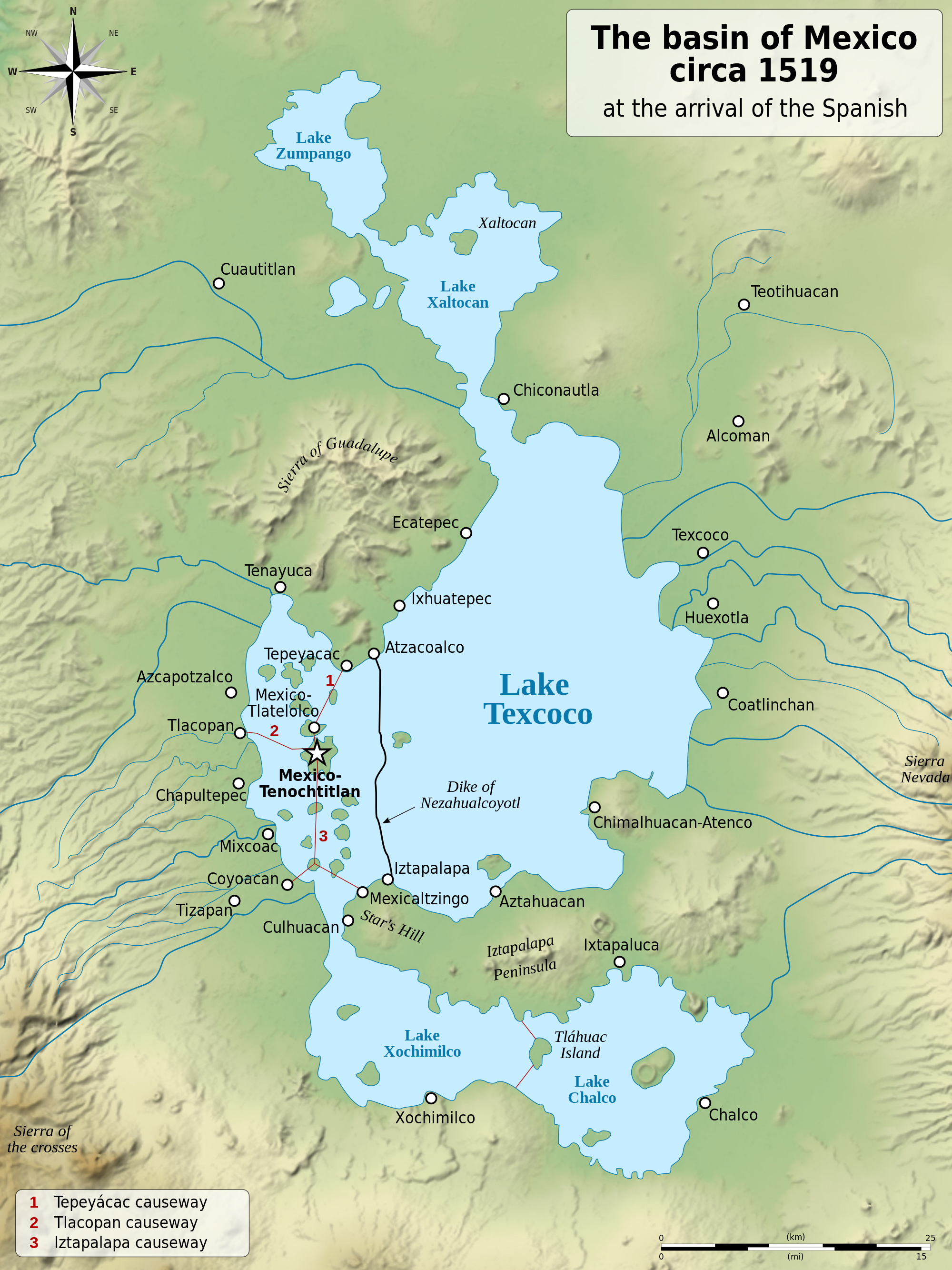
The history of Mexico City as a city has many facets, but two emerge in this context. First is the concept that the city is built on a lake. This map shows the configuration of the area around 500 years ago, about the time the Spanish arrived in Mexico.
Tenochtitlán, the major urban center, was established in 1325, a larger island surrounded by smaller areas islands amidst Lake Texcoco – shown as the City of Mexico below. This aided in defense and provided agriculture using the chinampas, islands floated for growing crops.
The city was rapidly transformed via defeat and colonization:
Then the conquering Spaniards waged war against water, determined to subdue it. The Aztec system was foreign to them. They replaced the dikes and canals with streets and squares. They drained the lakes and cleared forestland, suffering flood after flood, including one that drowned the city for five straight years.
The article focuses on both this concept of geological transformation. The second part of the story of Mexico City is the Grand Canal. This infrastructural intervention was completed in the late 1800s, and ” a major feat of engineering and a symbol of civic pride: 29 miles long, with the ability to move tens of thousands of gallons of wastewater per second. It promised to solve the flooding and sewage problems that had plagued the city for centuries.”
The City being built on a lake has led to subsistence due to geological forces, and the need for drinking water has meant well drilling on a huge scale – both leading to elevations of the city being dramatically lowers. This makes gravity-based infrastructure like the Grand Canal a bit problematic, as they can no longer freely drain. The city, which occupied a metropolitan area of 30 square miles in 1950, now occupies closer to 3000 square miles, so and the almost 22 million inhabitants exert massive pressures on the land.
Some great interactive graphics from the NYT show the canal in the context of the ancient lake bed that sprawls through the region (see how this relates to the map above).
This plays out in the map below, which highlights the worst place of subsidence – the darkest red portions sinking around 9 inches per year.
[Click maps for larger views or check them out in the original article for overlay]
The problems, as mentioned, are based on some bad decision-making in urban planning back centuries ago. This have been exacerbated by climate change – meaning lack of drinking water for many and the potential to lead to health issues, mass migrations to other cities, or conflict, which will be played out around the globe. This example of non-coastal impacts of climate change is one of the most interesting aspects of the story, as much attention has been placed on sea-level rise but less on inland communities. “Mexico City — high in the mountains, in the center of the country — is a glaring example. The world has a lot invested in crowded capitals like this one, with vast numbers of people, huge economies and the stability of a hemisphere at risk.”
One way this phenomenon is visible is in the architecture, with subtle rolling building forms as seen below creating waves of differential settlement. An animation of the process shows the action creating this building form, due to differential layers of volcanic soils and clays, which drain and hold water at dramatically different rates.
What happens when the water is drawn down creates instability reflected in the constant sinking and retrofitting of buildings. Kimmelman explains the impacts: “Buildings here can resemble Cubist drawings, with slanting windows, wavy cornices and doors that no longer align with their frames. Pedestrians trudge up hills where the once flat lake bed has given way. The cathedral in the city’s central square, known as the Zócalo, famously sunken in spots during the last century, is a kind of fun house, with a leaning chapel and a bell tower into which stone wedges were inserted during construction to act more or less like matchbooks under the leg of a wobbly cafe table.”
Aside from the quirky buildings, there are major issues throughout the region, more pressing as climate change increases. Kimmelman mentions that “development has wiped out nearly every remaining trace of the original lakes, taxing the underground aquifers and forcing what was once a water-rich valley to import billions of gallons from far away.” That conveyance of water is so difficult, that many residents are unable to get water easily, especially from taps. This has led to an economy of ‘pipas’, “large trucks that deliver water from aquifers” to fill tanks. Approximately 40% of residents get water this way.
The other issue is the difficulty of removing sewage and drainage, again because of geology and topography, along with leaks and inefficiencies of the aged infrastructure. The Grand Canal is no longer able to gravity flow, described as “wide open, a stinking river of sewage belching methane and sulfuric acid”. Pump stations are installed to assist this, and the canal, albeit ‘visible’ is marginalized, traveling under roadways and being polluted via impervious surfaces along the way.
While portions of the Grand Canal are still visible, the hidden hydrology and it’s implications, heightened by climate change, are evident in sinking buildings, lack of drinking water, and substandard infrastructure, a trifecta of issues that come back to the origins of a water based city from seven centuries back. I mention long history, and this is a lesson in how quickly the decisions of the past can turn on us with population growth and a changing climate.
Per Kimmelman: “The whole city occupies what was once a network of lakes. In 1325, the Aztecs established their capital, Tenochtitlán, on an island. Over time, they expanded the city with landfill and planted crops on floating gardens called chinampas, plots of arable soil created from wattle and sediment. The lakes provided the Aztecs with a line of defense, the chinampas with sustenance. The idea: Live with nature.”
The idea at the time, and even today is valid, but the modern challenge is confirmed by Loreta Castro Reguera, “a young, Harvard-trained architect who has made a specialty of the sinking ground in Mexico City, a phenomenon known as subsidence” who was interviewed in the article.
““The Aztecs managed. But they had 300,000 people. We now have 21 million.”
Xochimilco
A follow up from features the further story of the hydrology of Xochimilco, a UNESCO World Heritage Site that was covered by Victoria Burnett in a February 22nd story “An Aquatic Paradise in Mexico, Pushed to the Edge of Extinction” This article picks up the thread of the canals and islands from the original settlement. “With their gray-green waters and blue herons, the canals and island farms of Xochimilco in southern Mexico City are all that remain of the extensive network of shimmering waterways that so awed Spanish invaders when they arrived here 500 years ago.”
The article focuses on the impacts of water usage in the region, with water from Xochimilco being pumped to other areas of the city, creating sink holes and draining canals which threaten the livelihoods of farmers and tourism industries. The canals have long supported both industries, and also include wetlands and the infamous farming techniques called chinampas, which date back to Aztec era, and include ‘floating gardens’ in the shallow lakes. A photo of these from 1912 show the this in action:
The article discusses the residual impacts of development on the aquifers, which impacts the regions waterways, but also, similar to the previous article, creates subsidence that impacts buildings and sinkholes. The visible whirlpool in January lowered the water level quick enough to cause alarm before it could be stopped.
The water tourism in the area, typified by the trajineras, a blinged out local gondola, has been impacted as well. One of the operators takes heed of the omens of water, stating:
“Nature is making us pay for what we have done”
In additional to development (building on the chinampas), there is pollution of the canals themselves, which has jump-started some efforts to reduce water use of the aquifer through rainwater harvesting, but the immensity of the problem of supplying water for a region with 22 million people is massive. The balance between providing water and maintaining the cultural heritage means the possible loss of knowledge of chinampa farming, as well as health issues for locals. This could quickly become irreversible, unless action is taken, as mentioned by Dr. María Guadalupe Figueroa, a biologist at Autonomous Metropolitan University, who ends the article: “…without a serious conservation effort, the canals will be gone in 10 to 15 years. But much of the damage was reversible, she said, adding: “It’s still a little paradise.”
Invisible Rivers
The two articles reminded me of a couple of articles I had filed away for future posts. With the interest piqued from the above coverage, I dove into a 2016 CityLab post “Mexico City’s Invisible Rivers” which focuses on the work of Taller 13 and their plans to “uncover the 45 rivers that flow under the Aztec capital, hidden underground for decades.” The first phase involves the Piedad River, and the idea of daylighting 9.3 miles of the corridor. shown in some detail below (with many more images on their site via the link above or via an online document here).
There’s a lot of similarity to the Cheonggyecheon River in Seoul (mentioned here in the Lost Rivers documentary post) in terms of the final look and feel as well as the transformative potential, as mentioned in the article by urban biologist Delfín Montañana”
““This project shatters paradigms. It proposes to tear down a private road, which you cannot use unless you have a car. What we propose is that we remove the cars, open the pipes, and treat the water. We need to transform the model of our city”
The hidden gem in the post is the document “La Ciudad de México 1952 1964” published by the Departamento del Distrito Federal. México, This document outlines the public services of the city, including chapters on water and sewer that have some great info (with, in my case, some translation).
Sections on potable water and drainage show ‘modernization’ along with maps of these systems (of passable by not great quality). The following shows the drainage system of the time, which involved a lot of pipes and images of pipes being built, and people in pipes.
A colored map of the historic Mexico from the document takes us full circle, to the hydrological history, a city literally built on a lake, economies as well built on that watery foundation, and now dealing with the consequences.