My previous postscript ran somewhat longer than anticipated, due to the massive amount of work happening in and around New York City.  Thus a focus on this post on the cartographic, including some of the great resources available, and the rich history of maps new and old that emerge to tell a visual story of hidden hydrology in the city and larger region.  There are so many, that one who wants to dive in can jump down to the resources section below to see lots of great sites showcasing the maps, my focus here is to highlight a few I thought were interesting and beyond general map nerdiness, some that had a particular relevance to hidden hydrology.

An old version dates back to the early settlement times, from 1639 the Manatvs gelegen op de Noot [sic] Riuier (via Library of Congress) is a fun introduction to the area, north to the right showing the section of Manhattan (Manatvs) and areas surrounding.  Fun to see a map from this far back, and it does represent some of the topography and hydrology in some rudimentary ways.

The 1660 Castello Plan (original and a later reproduction drawn in the early 1900s) offers a glimpse of the tip of Manhattan, or New Amsterdam.

Many maps come via The Iconography of Manhattan Island, via Wikipedia “a six volume study of the history of New York City by Isaac Newton Phelps Stokes, published between 1915 and 1928 by R. H. Dodd in New York. The work comprehensively records and documents key events of the city’s chronology from the 16th to the early 20th centuries. Among other things, it shows the evolution of the Manhattan skyline up to the time of publication”  More: “Stokes’s worldwide research teams scoured public and private collections of maps, guides and obscure source material to complete his encyclopedic monument to New York City. It describes in detail the growth of a fortified Dutch settlement into a major city, and ultimately included six volumes sold to subscribers and libraries in a limited edition of 360 sets printed on Holland-made paper and 42 on Japanese vellum.”

The following plate from this Iconography is from 1693, showing Manhattan and the shift from New Amsterdam to Nouvelle Yorc:

The Bradford Map is another resource, showing “…the city of New York at the time of the granting of the Montgomery charter …” and “from an actual survey” and starting to highlight some hydrological resources like the Collect Pond.  The map is a reproduction from the 1800s, but shows the area in 1730 and is similar to the later Maerschalck map, showing similar area in the 1750s.

A beautiful map is a 1777 version Plan de New-York et des Environs, showing a similar zone with a lot more detail, a precursor of some of the more detailed maps (and sophistication of mapmaking) in the late 18th century.

A larger area comes via 1766-1777 and the Plan of the city of New York in North America – surveyed in the years 1766 & 1767 by Ratzer, showing a larger zone beyond the Hudson and East Rivers.

From the header above we see the influential British Headquarters map that was used heavily in the creation of the Welikia project.  This map shows the larger area of Manhattan in fine detail, with topographic relief – a zoomed in section shows why this was such an important historical document.

Fast forwarding a bit to the early 1820s, the Randel Map was an atlas of.  Via The Greatest Grid website: “Between 1818 and 1820, John Randel, Jr. prepared an atlas of 92 watercolor maps that vividly illustrates the properties, old roads, and major features of pre-grid Manhattan as well as the future location of the new streets and avenues of the 1811 grid.  Drawn at a scale of 100 feet to 1 inch, the Randel Farm Maps provide a detailed picture of Manhattan before its transformation. Hand drawn and colored, they are among the most significant documents in the history of New York as well as a rarity in American urban history, as no comparable maps exist for other early-19th-century American cities”.   There are 92 individual maps, but an online map stitches them together in a beautifully detailed composite here.

The maps got more broad, with titles to fit like “Topographical map of the city and county of New-York, and the adjacent country : with views in the border of the principal buildings, and interesting scenery of the island.” from 1836 showing the entire island of Manhattan with relief,

This was perhaps the precursor to one of the most fantastic maps, that created by Egbert L. Viele, the 1865 gem “Sanitary & Topographical Map of the City and Island of New York.

The detail is amazing, and it’s available as a high-res download at multiple sources, including Wikipedia which describes it as such: “…survey of the original streams, marshes and coastline of New York City, superimposed over the street grid. The map is still used by modern geotechnical engineers, structural engineers and planners to design the foundations of new buildings and structures in the city.”  A few close ups illustrate this point, and allow for georeferencing to the modern city:

A few other maps that caught my eye, specific to Hidden Hydrology Broadside of the Collect Pond, New York and Steam Boat (Five Points) highlights that the pond was still there in 1846 (or at least as represented here from 1793).

And the birdseye perspectives are another great resource, showing a different viewpoint.  As a tool to communicate place, I’ve always been fascinated by these, such as this 1870 version from Currier & Ives (source unknown as I got this via Twitter) but I believe it’s from Library of Congress.

And some map-objects and infrastructure systems that are fascinating, including this one, a ” Sketch showing the ground under carriageway at intersection of Wall, Broad, and Nassau Streets : as occupied by water, gas, steam, pneumatic, cable and electric pipes, sewers, basins, culverts and vaults to houses, etc., February 1885″  


There’s also a wealth of maps covering many Boroughs, but these map be for another time – and the resources below offer lots of chances for locals or the curious to dive in to more depth.

INTERACTIVE MAPS

There’s great interactive maps like  the interactive to quirky side, there’s a fun historical Spyglass Map, showing the New York City of 1836 vs. today,   The Smithsonian, had David Rumsey provide some discussion of this map to go along with an article about it, where: “Rumsey looks to the map’s delicate shading to tell much of its story, noting that the heavily shaded areas represent the most densely populated portions of the city at the time of the ma’s drawing. “Pretty much everything past 14th St. is country,” he explains, adding that much of what is considered Manhattan today wasn’t yet settled. In addition to the population shading, the hills of Manhattan are shown by hachures, an antiquated method of showing relief on drawn maps. “A lot of the history of Manhattan is the destruction of its hills,” Rumsey says. “Basically that topography was obliterated, except for Central Park.”

And a fun but perhaps limited in usefulness ‘Urban Scratchoff’, which does a similar thing with by revealing a 1924 map underlay.  I feel as if I keep scratching but never really win anything.

MAP RESOURCES

A great site focused on Manhattan that filled in much of the above content is the map page of Manhattan Past which is connected to the site and book ‘Street Names Past & Present’ focused on the place name origins of area around the City.  The maps are broken down chronologically back into the 1600s, with links to originals and some brief text, a great primer for delving into the larger pool.

Additionally, The Greatest Grid is a site that emerged from the exhibition The Greatest Grid: The Master Plan of Manhattan 1811-2011, at Museum of the City of New York in 2011 to 2012, which “documents the creation of Manhattan’s signature grid, which set a remarkably flexible framework for growth as a town of 100,000 in 1811 became today’s world city of 1.8 million people (in Manhattan only). Balancing order and freedom, uniformity and individuality, the grid continues to serve as a model of urban planning in the 21st century.”  Some great background on the development of the city and the grid, as well as great maps, are found within.

The resources available are amazing, drawing on local and international institutions – one of the best being the Open Access maps from the New York Public Library, where the The Lionel Pincus & Princess Firyal Map Division has over 20,000 free, high resolution downloads available, many of the maps above coming from this source, and their active Twitter feed @NYPLMaps showcases many more.

Plan of the town of Brooklyn and part of Long Island – 1767 (NYPL)

Another I thought was very comprehensive and well organized was via Stony Brook University called NYS Map Pathfinder.  Larger institutions carry plenty of maps of New York City due to it’s significant, as The Library of Congress has extensive holdings for New York City, and as most map nerds know, the David Rumsey collection is the go to for maps, including lots for New York, with some great tools, as well for viewing and sorting.  Just sifting through you find the historic, but a wealth of interesting map techniques, such as this Map of Greenwich Village made for the Whitney Studio Club from 1920.

And speaking of other non-historic maps, not specific to hidden hydrology, I’d be remiss without mentioning the New York version of Rebecca Solnit’s atlas collection Nonstop Metropolis, A New York City Atlas, authored with Joshua Jelly-Schapiro and true to form with the other regional versions from San Francisco and New Orleansis part of the compendium of maps as storytelling devices.  Read this great long essay via Public Books entitled Visible Cities by Laura Yoder for where she dives into “maps that catalogue social and cultural complexity, and teach us to engage with difference in productive and generous ways.”  Another good review via Hyperallergic, “Creating an Atlas of Overlooked Cartography for New York City” where they relate that “Every map is an intense act of creative collaboration, with essays and illustrations in Nonstop Metropolis from over 30 artists and writers.”  The image below is indicative of this style, showcasing “Wildlife”

A book that looks interesting by Marguerite Holloway is the author of The Measure of Manhattan: The Tumultuous Career and Surprising Legacy of John Randel, Jr., Cartographer, Surveyor, Inventor, and another on the maps, there’s the 2014 publication Manhattan in Maps 1527-2014 by Paul E. Cohen &‎ Robert T. Augustyn 

For modern mapmakers, there’s a rich collection of resources, including NYCityMap and OASIS both displaying tons of thematic info on current conditions in the city, the latter even providing a historical slider showing the Mannahatta layering.

I could post maps and larger stories of hidden hydrology every day for a year and not run out of interesting tidbits here in the Big Apple, which reflects the richness of historical context and also the passion for many people to investigate their hidden hydrological histories.  And it seems a fitting segue to where we are heading.  Next up, we head over the pond to the undisputed champion of Lost Rivers – London.

Stay tuned.


HEADER:  Facsimile of the unpublished 1782 British head quarters coloured manuscript map of New York & environs – via David Rumsey

A follow-up to the previous post allows for a bit more expansion on the fundamental sources for New York City.  This includes the Welikia Project and it’s beginnings as Mannahatta, as well as the comprehensive book by Sergey Kadinsky on the Hidden Waters of New York City.  We delved deep with Steve Duncan’s sewer explorations and blog Watercourses and Undercity,  Together these make up a solid fundamental base of hidden hydrology work in New York City.  This also complements some of the projects I’ve covered, including the project Calling Thunder, which evoked the power of historical ecology via animation, the explorations around hidden infrastructure of photographer Stanley Greenberg, and some of the walks and installations focused on hidden streams with artist Stacey Levy.

That said, there’s still much more, so a postscript is in order to provide a bit of additional context to even claim to be a passable (although not even close to comprehensive) review of some of the city, with a focus on including some tours, art, history, and more.

SOME TOURS

One aspect of any place is explorations, and there is no shortage of tours around hydrology in New York City.  The group NYC H2O is a great resource for this, with a mission “…to inspire and educate New Yorkers of all ages to learn about, enjoy and protect their city’s local water ecology.”  They’ve hosted some great events in the past year alone, including tours with Steve Duncan, Sergey Kadinsky, and artist Stacey Levy as well as many others. City as a Living Laboratory (evolved out of the work of artist Mary Miss) also provides some great events, include walks, such as this one exploring the past and future of Tibbetts Brook with Eric Sanderson and others.

There are some less formal characters as well, like local activist Mitch Waxman, featured here in a NY Times article from June 2012, “Your Guide to a Tour of Decay”.  The article shows how he discovers, teaches and advocates about the hidden history of Newtown Creek in Queens, where, as quoted in the article: ““You have these buried secrets,” he said, explaining the thinking behind the occult conceit. He’s spotted early-19th-century terra-cotta pipes protruding from bulkheads, antique masonry sewers connected to who knows what. He added: “There really is no telling what’s in the ground there.”

And, for a somewhat related example, there’s always the amazing precedent of Safari 7, a self-guided subway based audio tour and map that highlighted “…urban wildlife along New York City’s 7 subway line”.  A map of the guide is found below.

SOME ART

In terms of some hidden hydrology based art installations, there are many that span permanent to ephemeral.  In the site specific realm, is Collect Pond Park, which was located in Manhattan historically as “…a large, sixty-foot deep pool fed by an underground spring” that was filled in the early 1800s.  A post here by Kadinsky & Kevin Walsh on Forgotten New York discusses the project and includes this rendering that highlights the interpretation of previous pond in the design of the new park. This includes a “…footbridge spanning the pond’s waist hearkens to the original pond’s shape, providing a historical link to a pond that has had such a huge role in the city’s history, before and after its burial.”

Another site is a fountain at Albert Capsouto Park, which references some hidden hydrology. From the Parks website:  “The centerpiece of Capsouto Park is a 114-foot long sculptural fountain by SoHo artist Elyn Zimmerman. This fountain bisects the interior space. Water spills from an 8-foot tower into a series of stepped “locks” evoking the canal that once flowed along the Canal Street. A sunning lawn rises up to meet the fountain from the south and granite seat walls adorn the fountain to the north.”

Capsouto Park Water Feature, 2009 – Elyn Zimmerman & Gail Wittwer-Laird

We discussed previously some of the hidden hydrology art of Stacey Levy, which was the tip of the iceberg of vibrant art scene in NYC interpreting hydrology as the medium.  One larger effort worth noting is Works on Water, which is “…an organization and triennial exhibition dedicated to artworks, theatrical performances, conversations, workshops and site-specific experiences that explore diverse artistic investigation of water in the urban environment.”  Their mission statement by the team sums up the potential:

“New York City has 520 miles of coastline. Its waterways are often referred to as “The Sixth Borough”. We are artists and curators dedicated to working with water to bring new awareness to the public of the issues and conditions that impact their environment through art.”

The sum of work there is worthy of it’s own future post.  In the interim, a few of the key contributors to Works on Water have their own complementary endeavors, such as Liquid City, a water based project by artist Eve Mosher, a self proclaimed “…water geek, urban enthusiast and playworker in training”, whom is “…fascinated by our waterways, the space they inhabit the roles they play in our daily life and finding ways to create a greater engagement across disciplines and a greater awareness in the public narrative.”

Liquid City: Currents (Eve Mosher)

Her project aims to be the following  “1. A research database of collected resources and video stories of people working on the urban waterways. An open source compendium for creative inspiration,  2. An interdisciplinary floating think tank/lab working on creative interventions about the urban waterways, and 3. A traveling think tank/lab sharing resources, traveling the Great Loop’s urban waterways.”   A fascinating work on her site is the Waterways System Map below (click the link for the fully interactive version) which involves “mapping the existing system of the waterways” in extraordinary detail.

Below is another of Mosher’s project, from  exhibit: “As part of Works on Water, I collaborated with Clarinda Mac Low to create a large scale floor painting of the NY waterways. Intended to ground people in the specific site of water as material within the exhibition, the waterways acted as a guide into the exhibition space.  Overlaid on the waterways was a video in which I represented the historic waterways and Clarinda imagined the future…”

A different project led by Kira Appelhans, adjunct assistant professor, Integrated Design Curriculum, Parsons The New School and Richard Karty, postdoctoral fellow in Environmental Studies, from 2011 is entitled Waterlogged. The endeavor “…explores the process of mark-making in the landscape from glacial to hydrologic to human.  We will examine the existence of remnant waterways and their relationship to the city’s organizational patterns and forms.   Using printmaking, restoration ecology, public space design we will explore the ecological impact of the intersection of historic waterways and urban infrastructure.”  The diverse artworks are captured in a video as well as a booklet ‘Remnant Waterways‘ (pdf) which showcases the work of students, including prints inspired by buried streams.

Iteration 3 – Eve Neves
Print by Mikaela Kvan

In the realm of photography, the work of Stanley Greenberg and Steve Duncan show two sides of underground New York City, and photographer Nathan Kensinger, who investigates “The Abandoned & Industrial Edges of New York City” shows a third.  He has an ongoing series entitled “New York’s Forgotten Rivers” where he has been documenting “New York City’s last remaining aboveground rivers and streams, in all five boroughs.”  An image below shows one of these photos.

Another recent exhibition “To Quench the Thirst of New Yorkers: The Croton Aqueduct at 175” that just completed it’s run at the Museum of the City of New York, offers a similar theme, with the tag line: “Uncover the hidden history of New York’s original water source, buried beneath the city”, it features “…newly commissioned photographs by Nathan Kensinger, tracing the aqueduct’s route and revisiting sights that Tower had sketched nearly two centuries before.”

Shifting from the visual to the literary, I previous mentioned the great Robert Frost poem covered in Hidden Waters blog, focused on Minetta Creek.  Another literary reference worth a look is this 1998 poem by Jim Lampos “Gowanus Canal” about the partially hidden and very polluted waterway in Brooklyn.  The whole thing is worth a perusal in detail, but I was struck by this passage, which evokes some of the history of place so acutely:

“I’ve come with a notion 
Old Gowanus, to recollect 
the splinters of dreams 
and severed fingers 
you’ve tucked away, 
the stolen pistols 
and sunken treasures 
you’ve saved 
the piss, tears 
dreams and sweat 
you’ve claimed. 
Recollect–shitty Canal 
stinking to the heavens– 
that you were once a river 
and hills rose from both 
your banks.  Brooklyn Heights 
nourished you as it returned 
your borrowed waters sweetened 
with the blood of revolution. 
A city was built 
all around you– 
a city of pizza parlors, churches and 
Whitman.  A city of pigeons, 
ice factories and hit men.”

SOME HISTORY

Tons of possibilities to cover in the history genre, as New York City has a million stories, In picking a few, I decided to focus on the ones that rose to the top due to their sheer uniqueness.  The one that was amazing to read about comes via Geoff Manaugh at BLDGBLOG, referencing a complicated series of posts about Fishing in the Basements of Manhattan that goes back to the NY Times blog ‘The Empire Zone’ and eventually a post link to a comment from 1971 Letter to the Editor, which mentions this potentially tall tale:

“”…We had a lantern to pierce the cellar darkness and fifteen feet below I clearly saw the stream bubbling and pushing about, five feet wide and up-on its either side, dark green mossed rocks. This lively riverlet was revealed to us exactly as it must have appeared to a Manhattan Indian many years ago.  With plum-bob and line, I cast in and found the stream to be over six feet deep. The spray splashed up-wards from time to time and standing on the basement floor, I felt its tingling coolness.  One day I was curious enough to try my hand at fishing. I had an old-fashioned dropline and baited a hook with a piece of sperm-candle. I jiggled the hook for about five minutes and then felt a teasing nibble. Deep in the basement of an ancient tenement on Second Avenue in the heart of midtown New York City, I was fishing.  Feeling a tug, I hauled up in excitement and there was a carp skipping before me, an almost three pounder. I was brave enough to have it pan-broiled and buttered in our upstairs kitchen and shared it with my brother…”

Going way back, a few folks referenced what seems an interesting resource, “Springs and Wells of Manhattan and the Bronx, New York City: At the End of the Nineteenth Century” by James Reuel Smith, in 1938, in which “…he reflects on the rapidly changing city and on the practical and aesthetic pleasures offered by the remaining springs: “In the days, not so very long ago, when nearly all the railroad mileage of the metropolis was to be found on the lower half of the Island, nothing was more cheering to the thirsty city tourist afoot or awheel than to discover a natural spring of clear cold water, and nothing quite so refreshing as a draught of it.” 

A photographer as well (see more in this collection “Photographs of New York City and Beyond” , his images are great documents of these sites which I’d imagine are mostly gone, although recently noted is a new discovery of a well in Brooklyn that dates back to the Revolutionary War era.

James Reuel Smith. Unidentified woman drinking at Carman Spring, on W. 175th Street east of Amsterdam Avenue, New York City. undated [c. 1897-1902]. Glass plate negative. New-York Historical Society.

Some more recent books note I’d love to delve into include the recent “Taming Manhattan: Environmental Battles in the Antebellum City” by Catherine McNeuer (2014), Gotham Unbound: An Ecological History of Greater New York,  (Steinberg 2015) and Water for Gotham: A History. (Koeppel, 2000) all of which paint a portrait of historical ecology that complements the inquiry of hidden hydrology.

Other short reads include Thomas J. Campanella’s essay in Terrain.org, “The Lost Creek”, and a great article connecting west to east worth from Nathan Kensinger, “What Can NYC Learn from San Francisco’s Last Wild Creeks?” where he looks at Islais Creek (and of course includes some amazing photos) as a model for how aboveground creeks can be a model.  He summarizes: “Flowing through an increasingly gentrified city,…this historic stream offers up a refreshingly untamed landscape. Though it travels just five miles from its headwaters in Glen Canyon to its mouth in the San Francisco Bay, and is bisected by a three mile underground segment, Islais Creek provides critical support to two radically different natural environments, both of which are currently undergoing extensive renovations. It also illustrates several approaches to urban planning that are unfamiliar to most New York City waterways.”

Islais Creek – photo by Nathan Kensiger, via Curbed NY

SOME MISCELLANY

With any discussion of hidden hydrology, the concept of daylighting always emerges as certain projects seem to lend themselves to this approach.  A presentation by Steve Duncan is worth a read as it covers this topic in depth, and the project with the most traction is Tibbets Brook, in the Bronx.  Located in Van Cortland Park, the daylighting push garnered a fair amount of press (here, here) and also a petition, with a detailed coverage in Untapped Cities from 2016 which shows an image from a report “Daylight Tibbetts Brook” (PDF file – from Siteation).  A figure from the report shown below identifies a potential route of the daylighted creek.

Before and After views of daylighted creek

Another final item worth discussing, albeit removed from hidden hydrology explcitly, is the image of climate change on the city.  We cover this in the context of modern New York via Kim Stanley Robinson’s New York: 2140, which imagines a flooded, post-catastrophe New York with, a narrative of New York as a “SuperVenice”, rife with political upheaval, class warfare, and and salvage operations referencing historic maps — setting the stage for a new geography that is equally fantastical and plausible.  As mentioned in the New Yorker:

“Another narrator—a nameless urban historian—tells the story of New York from a bohemian point of view. America’s boring losers all moved to Denver, he says, and so the cool kids took over the coasts. “Squatters. The dispossessed. The water rats. Denizens of the deep, citizens of the shallows.” The abandoned city becomes an experimental zone—a place where social innovation (“submarine technoculture,” “art-not-work,” “amphibiguity”) flourishes alongside “free open universities, free trade schools, and free art schools. Not uncommonly all of these experiences were being pursued in the very same building. Lower Manhattan became a veritable hotbed of theory and practice, like it always used to say it was, but this time for real. . . . Possibly New York had never yet been this interesting.”

The connections between this fictionalization and the changing climate that could lead to more frequent flood events, seems a timely connection between history (past) and what it means now and into our our future.  The story told by Robinson may be a bit lacking in places, but the details and context is compelling.

The vision of a flooded city in “New York 2140,” a science-fiction novel by Kim Stanley Robinson, is surprisingly utopian. via New Yorker

As you can see, there are literally hundreds of links for particular creeks, art, history, explorations, tours, and other discussions around New York City.  My original goal was to also include maps in this post, but as you can see it’s already bursting at the seams, so I will conclude New York with one additional post focused on the cartographic as to not overwhelm.


HEADER:  Bronx River, image by Nathan Kensinger as part of his New York’s Forgotten Rivers series.

As we’ve seen in the Welikia Project and the book Hidden Waters of NYC there’s multiple ways to approach the investigation and documentation of hidden hydrology in the same city.  Next is a hybrid photography, infrastructure history and adventurous drainer in the form of Steve Duncan.  Since the 2010s, he’s been featured often, the theme similar to these stories from NPR “Into The Tunnels: Exploring The Underside Of NYC” as well as the New York Times (here “The Wilderness Below Your Feet” with Norwegian explorer Erling Kagge).

Duncan, here smiling after the third night camping underground, is a graduate of Columbia University and is working on his doctorate in urban history at the University of California. via NPR

His photography is pretty stunning, (links to the original photography site seem down, but you can buy a print here) and more than a few articles feature his explorations and work, including this New York/London feature in the Daily Mail, “A tale of two underground cities: Urban explorer’s stunning photographs of the subways and sewers of New York and London”  Here’s Duncan at work:

His photos are featured as well in National Geographic “11 Rivers Forced Underground” which include New York as well as other cities around the world.  A few of the shots:

Sunswick Creek, New York City (Photo by Duncan)
Tibbets Brook, New York City (Photo by Duncan)
River Sheaf – Sheffield, England – Photo by Duncan)

My favorite below as the idea of canoeing this hidden streams is a bucket list dream for me.  This one is of the Park River in Hartford Connecticut.  From the NatGeo article: “Today, a few intrepid urban explorers paddle canoes down the buried river. John Kulick of Huck Finn Adventures, who has guided float trips through the subterranean section, told the New York Times he has seen eels, carp, and stripers in the dark water. Kulick joked, perhaps at least half seriously, that a burst of water gurgled into the river because “someone flushed a toilet.”

Park River, Hartford Connecticut (Photo by Duncan)

The site Watercourses provides the more academic side of this inquiry, dating back to 2008-2010 with a goal of “Looking for the lost streams, kills, rivers, brooks, ponds, lakes, burns, brakes, and springs of New York City.” As much of it isn’t regularly maintained, it’s still great repository of info, maps, photos, and lots of good links.  Organized into regions and sites, with a sidebar around “Named Streams, Ponds, & Springs” it’s a wealth of info to dig into and some great, NY specific info.  As mentioned in the introduction:

“Almost all of the the streams, ponds, swamps, tidal inlets, flood plains, springs, etc that once dotted the fertile land seem, at first glance, to have disappeared underneath the tide of New York City’s urbanization. This is not completely true. In many cases, the city retains the imprint of these features; in the shape of a road, for example, like Water Street in lower Manhattan, that used to follow the edge of a stream or river; or sometimes just in the name of a neighborhood or street.”

For instance, one of the posts on Minetta Brook yields a snip from the Viele Water Map (more on this in an upcoming post) showing the course:

Plus this great 1901 article from the NY Times on excavating the creek.

Undercity is the other side/site of Duncan with posts ranging from 1999 through a sporadic fits and an end in 2015 with a focus on the “Guerrilla History & Urban Exploration” side of things.  These posts offer a great array of topics, like how 9/11 impacted urban exploration, the lives of the Mole people, and even a blurb in the difficult to reproduce on black pages local NW Design mag Arcade.

Like many websites of a certain vintage, there’s plenty of broken links (unfortunately the Explorations tab being one of them) but still lots of great info – also a gruesome shot of Duncan’s hand and after story when he slipped and sliced it open during one of his explorations.  Sifting through the links, there are some really hidden gems, inlcuding a book link I’d not seen before for New York Underground: Anatomy of a City, and some great posts about England and Rome around March 2009.

My hands down favorite is this link to a Life Magazine story from November 7, 1949 on ‘Underground New York’, which featured some amazing cutaway images like this one on the complexity of subsurface infrastructure:

For some additional reading by Duncan himself, there’s a thoughtful essay on Narrative.ly from 2012 “An underground explorer discovers his city’s lost lifeblood” in which he discusses the importance of the historic streams in New York, their eventual destruction:

“With further development came the burial of Tibbetts Brook, and many of the other streams. In some cases, putting them underground was merely a way to create more buildable land above. In others, the streams that once supplied drinking water or fish were converted into sewers and drains. Today, the lineage of many of the major sewer lines in New York City can be traced back to streams and rivers that flowed unfettered for centuries and even millennia before the city matured around them. Today, their past is all but forgotten.”

He continues the essays through some exploration of Tibbetts Brook, and discussion of the Canal Street sewer, New York City’s first, discussing many of the creeks, through actually following their current form. Many of them as he mentions, are too small to explore underground, being only a few feet wide, but “it is impossible to completely parse out the old “natural” Minetta Brook, or the Tibbetts or the Sawmill, from the urban landscape and sprawl of the modern-day “Big Apple”—but that doesn’t mean they’re gone. Far from it.” 

There’s also a great video by filmmaker Andrew Wonder from 2010 called UNDERCITY which follows Duncan underground.

UNDERCITY from Andrew Wonder on Vimeo.

Some great background on a pioneer in the urDuncan on Twitter @undercitysteve where he’s giving tours around the city.  He’s also on FB, which i am not but probably easy to find via a search. There’s a link on Twitter to another site undercity.org but it wasn’t working for me.


HEADER IMAGE:  “A self-portrait taken by Steve Duncan in New York City’s Croton Aqueduct, 2006” Photo By Steve Duncan, via NPR

Another fine resource that adds to the hidden hydrology knowledge base in New York City is Sergey Kadinsky’s Hidden Waters of New York City, which “serves as a guide to the stream by tracing their development along their courses” (xiii).  The book takes a different yet complementary direction than the Welikia project and other efforts I’ve mentioned and will follow up on.  Publishes in March, 2016, the book summary via Amazon provides some context: “Beneath the asphalt streets of Manhattan, creeks and streams once flowed freely. The remnants of these once-pristine waterways are all over the Big Apple, hidden in plain sight”

Kadinsky’s day job is at the New York City Parks Department, has experience as a tour guide, also teaches and contributes to Forgotten New York, all of which provides a good context for open spaces, as well as a forum for the stories of hidden and forgotten waterways of the area.  As he mentions in the brief introduction:

“The city’s waterways have become a place where the public is reminded of nature’s presence in the city.”  He continues mentioning specifically that inland areas, where “…waterways are not as visible, having been buried beneath the streets and concealed behind building. If one searches carefully, one can hear sounds of hidden streams churning beneath manholes and see traces of them in street names that recall a water past.” (xiii).

Covering Manhattan, The Bronx, Queens, Brooklyn, and Staten Island in different sections, the breadth of the book is it’s major take-home.  Any New Yorker would be doing themselves a favor by picking up a copy and being surprised to find out that you don’t have go far to find an interesting historical place you probably didn’t know about.  The short blurbs about each area come with a variety of factoids, as well as good local destinations and options for travel via bus, subway, and bike.

The content is great, albeit brief as the book covers, as mentioned on the cover, “101 Forgotten Lakes, Ponds, Creeks, and Streams”.  The typical post gives a tour of the place, some history, and delves into some specific topics, for instance the early chapters on the Collect Pond, Harlem CreekMinetta Brook, and Canal Street (all links to the blog) provide great anecdotes about infrastructure, geology, cultural history, and the forces that led to the eventual burial of these places.  Some are hidden, others are brought back metaphorically or through places names, and many still remain hidden.  Others are more brief, with the history of the place and some brief info suffice.

A review of the book by Eric Sanderson and Christopher Spagnoli via The Nature of Cities from November 2016 entitled  “Where did all the Streams Go?”  offers a bit more context on the book from folks that are admittedly more local in viewpoint.  As mentioned: “Kadinsky’s descriptions of waters invoke the flow of time” and provide the following, which capture the nature of the stories held within the book:

“Perusing Hidden Waters is fun for both the armchair historian and the modern urban eco-adventurer. Without sermonizing, there is a distinct historical rhythm to these accounts. Most begin with a colonial description of a typically beautiful, formerly long-lasting, watery feature of the environment, many of which formed during the last Ice Age—that has been co-opted for industrial purposes. Nineteenth century New Yorkers largely regarded waterways as places to get power, launch vessels, and/or dispose of sewage and garbage. Once these ponds, streams, and other waters were fouled, the city government and private actors, on the hunt for more land to develop, filled and paved them, a process that played itself out in fits and starts from the late 19th century through most of the 20th century. The natural waters we have left now are largely the result of neglect—so little time, so many streams to fill—until the environmental movement of the late 20th century finally created the legal and regulatory tools to stop their destruction.”

Perhaps a case where the blog is better than the book as the “companion blog for the book ‘Hidden Waters of NYC’ provides more room and allows Kadinsky to venture beyond the format the book constrains him to both geographically and visually.  For me the depth of information in the book pales in comparison and seems lacking in what Kadinsky covers in the blog, with more informal stories and visuals.  As a field guide, it seems a bit too text heavy, and lacking in really good contextual maps where one could follow along and tour through the narrative in a way that allows the story to unfold. This may be more a personal preference, however, the the overlay of new/old is fundamental to engaging with this type of historical ecological information, perhaps best addressed by the compelling map visuals of the Welikia Project.  Although it’s available on the blog, it is the one thing sorely missed in the book.

The notable narratives that I’ve read on the blog are many, but include a fascinating account of Robert Frost’s 1923 poem ‘A Brook in the City’ which recounts Minetta Creek,  a post recounting some Map Oddities, some cool examples of interpretive paving on Broad Street, the many posts about Central Park, many more I’ve bookmarked.

He also includes a two part reading list with some great additions to the local and broader context, including connections to Stanley Greenberg and others beyond the realm of water.  In highlighting the book I’m aiming to showcase what i think is a great contribution, namely writing about hidden hydrology, and also to provide some thoughts about what works in curating and narrating these stories of place.  It’s hard to capture in book form, the spirit of what is lost, the history of then, erasure, time and what is still there (a dilemma faced by much of the hidden hydrology literature).  In the end any text that endeavors to do so needs maps,  and lots of them, to support this effort.

Read the blog and follow him on Twitter @SergeyKadinsky and you’ll see more of this great example of a passion for place and hidden hydrology that connects people to their home places, Kadinsky’s book and blog aid in this.  He mentions this connection in the intro, and his work helps make true that “inland waterways today have resumed their role as vital elements of the city’s identity; providers of a sense of place.”


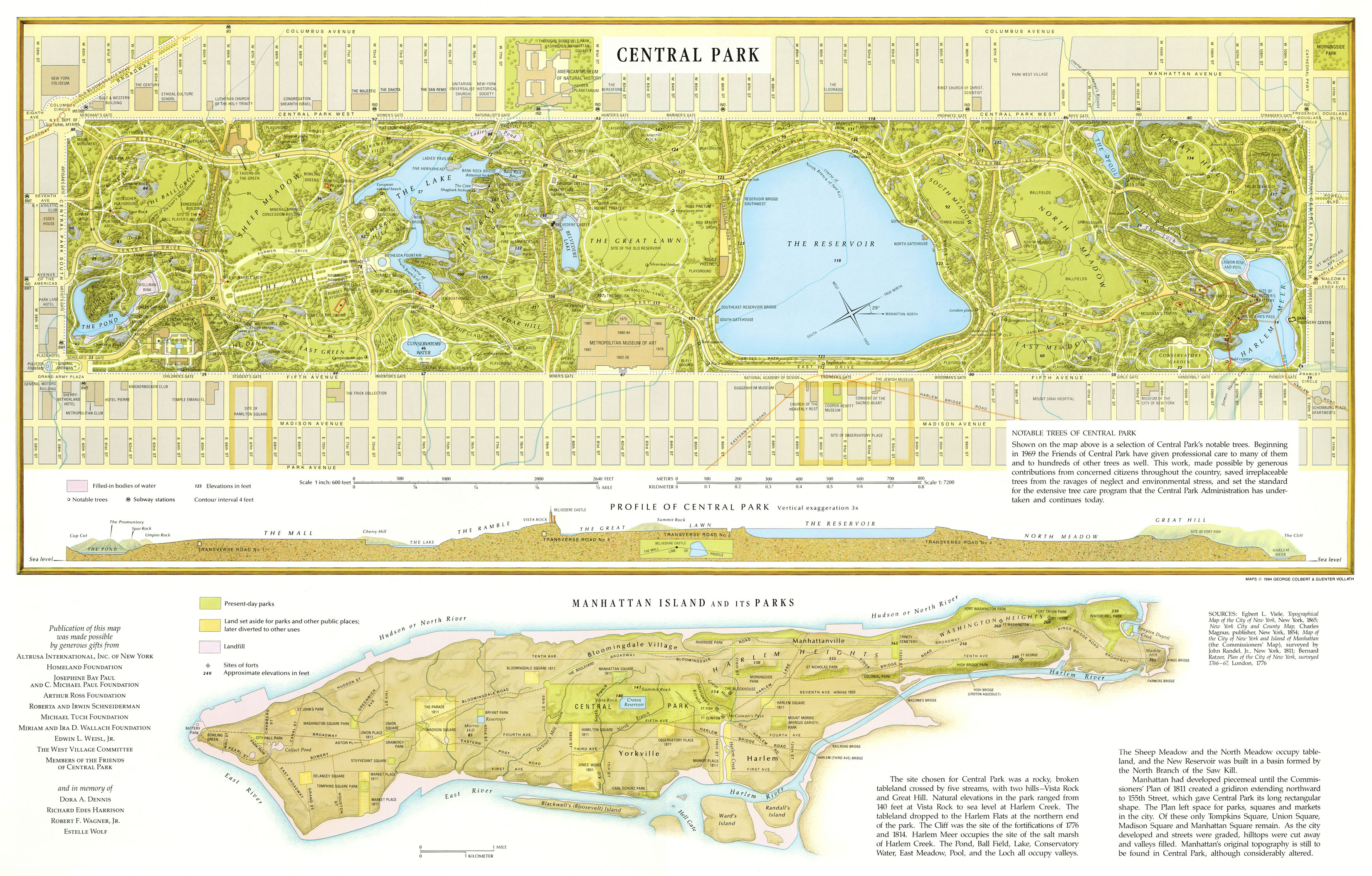
Header image: 1994 Greensward Foundation map of Central Park from this post here.


As I mentioned, New York City and the larger metropolitan region is an important case study in hidden hydrology, with a range of interesting activities spanning urban ecology, history, open space, art, subterranean exploration, and much more.  As a city with a long and vibrant history it’s not surprising that the story of water would be equally compelling.  The following few posts will expand on some of the key activities that shape the hidden hydrology of the city.

Times Square then and now: the area featured a red-maple swamp frequented by beavers, wood ducks, and elk. – via the New Yorker

Almost a decade or so ago, I read this story in the New Yorker about Henry Hudson, the year 1609, a map, and an effort by a group of people, including ecologist Eric Sanderson, to research and visualize the historical ecology of New York City. I posted this  and posted it to my blog Landscape+Urbanism.  This was one of the catalysts, and I’ve discussed this project in the past as one the key Origin Stories around my personal interest in Hidden Hydrology.

Mannahatta Map – via NYC 99 ORG

The publication of the ideas with the publication of the Mannahatta book (originally out in 2009 and with new printing in 2013) and this broader work by Eric Sanderson (and his very well loved TED Talk) and crew on visualizing and creating rich data landscapes for Manhattan and the larger region is constantly compelling, and the shift to a broader scope under the name The Welikia Project in 2010 was really exciting to see.

The Welikia Project expands the  provides a rich and well documented study of the historical and ecological study of New York City dating back over 400 years and inclusive of a range of interpretation from art, ecology, and design.  The overview of Welikia here provides a much longer and more complete synopsis of the project, but I’ll pick some of the interesting ideas I think are worth of discussion in information larger ideas about hidden hydrology.

The main page offers a range of options that the project provides.  Per the overview page, “The Welikia Project (2010 – 2013) goes beyond Mannahatta to encompass the entire city, discover its original ecology and compare it what we have today…  The Welikia Project embraces the Bronx, Queens, Brooklyn, Staten Island and the waters in-between, while still serving up all we have learned about Mannahatta.  Welikia provides the basis for all the people of New York to appreciate, conserve and re-invigorate the natural heritage of their city not matter which borough they live in.”

Tools include some downloads include curriculum for teachers to use, and some publications and data also available which would be fun to explore more.  A few notable bits of info worth exploration is this page “How to Build a Forgotten Landscape from the Ground Up”, which is a nice overview of the methodology used by the Welikia team, and provides a nice blueprint for organization of data that is transferable to any locale.

The original historical 1782 British Headquarters map was the genesis of any number of overlays that, once digitized into GIS, provided a historic base to layer additional information from other sources, along with inferences by professional ecologists and other members of the team.  These were also able to be georeferenced, which allows for the overlay of historic to modern geography, which becomes the basis for some of the larger interactive mapping we’ll see a bit later.  A map series from the Welikia site demonstrates the layering and aggregation possible.

1782 British Headquarters Map
Elevation differences from 1609 to today
Digital Elevation Model
Ecological communities

The concept of Muir Webs was also a fascinating part of the original Mannahatta book, so you can learn more about this on the page and via this presentation “On Muir Webs and Mannahatta: Ecological Networks in the Service of New York City’s Historical Ecology”

This Muir Web shows all the habitat relationships for all the species on Mannahatta. Visualization by Chris Harrison of Carnegie-Mellon University. ©WCS

Welikia Map Explorer – Lots of interesting background that I’ve literally barely scratched the surface of.  As I mentioned, the beauty of Mannahatta was the visualization of the historic surface, and through mapping with georeferenced location, provided an easy opportunity to create overlay maps of historic and modern.  The key part of this project is the Welikia Map Explorer, which offers a simple interface that can unlock tons of information.  Starting out, you have a full panned out view of the 1609 map visualization for Manhattan.

By selecting an address or zooming, you can isolate locations or just navigate.  It’s got that same video game quality I mentioned in my recent post about the DC Water Atlas, with some exploratory zooming and flying around the landscape looking at the creeks, wetlands and other area, you half expect to click and launch some next part of a non-linear exploration game.   The detail is amazing, and the juxtaposition between the very urban metropolis of New York City with this lush, pre-development landscape is striking both in plan, as well as some of the 3D renderings above.

You can then select any block and it will pop up a box that allows you to access lots of data underneath on a smaller level.

The interface provides layers of site specific data, and breaks down items like Wildlife, potential presence of Lenape (original native inhabitants, and Landscape Metrics. “Welcome to a wild place: this block in 1609! Through the tabs below, discover the wildlife, Native American use, and landscape factors of this block’s original ecology, as reconstructed by the Mannahatta Project. You can also explore the block today and sponsor the Mannahatta Project into the future.”

The Modern Day tab relates back to OASIS maps of the modern condition, making the connection of specific places easy to discern. “Landscapes never disappear, they just change. Click on the image below to see this block today through the New York City Open Accessible Space Information System (OASIS) and learn about open space and other contemporary environmental resources.”

For the beautiful simplicity of the map, it’s easy to lose sight of the fact that this is dense with real data and models that attempt to provide a real viewpoint to what each parcel was like 400+ years in the past.  We discuss baseline conditions much in design, stormwater, ecology and habitat studies, and this level of evidence-based, site scale data is so important to decisonmaking not just in terms of former waterways, but in restoration and management of spaces.  This is summed up on the site:

“An important part of the Mannahatta Project is not leaving ecology in the past, but to appreciate it in our current times, to see how we can live in ways that are compatible with wildlife and wild places and that will sustain people and planet Earth for the next 400 years.”

Visonmaker.NYC – Of the more recent expansions of this is the creation of Visionmaker NYC, which “allows the public to develop and share climate-resilient and sustainable designs for Manhattan based on rapid model estimates of the water cycle, carbon cycle, biodiversity and population. Users can vary the ecosystems, lifestyles, and climate of the city in an effort to find and publish sustainable and resilient visions of the city of the future.”

Worthy of a full post on it’s own, the idea is to emphasize the link between the Mannahatta era of 1609, the current era four centuries later, around 2009, and a future world into the future another 400 years in 2049.  This gives a great opportunity to create a key linkages between historical work, current scenarios, and future conditions.

As they mention: “A vision is a representation of a part of New York City as you envison it. You select an area and can change the ecosystems – buildings, streets, and natural environments – as well as the climate and the lifestyle choices that people living in that area make.” and you can also view other published visions done by users of all ages.  The interface is similar to Welikia, as it allows an overlay of layers with varying transparency for comparison.

More on this as I dive in a bit, but you can also watch a more recent 2013 TEDxLongIslandCity video shows this tool in more detail:

The mapmaking is of course pretty awesome, and they keep posting new visualizations and updates, such as this 1609 topo map, posted via Twitter via @welikiaproject on the “Preurban (year 1609) topography and elevation of

There was also some great local quirky info, such as this map and historic photo showing perhaps the strangest remnant geological remnant in a city I’ve seen.  Via Twitter from December 2016, “29 Dec 2016  “Rocky outcrops in NYC, were mostly concentrated in Manhattan and the Bronx and composed of schist and gneiss.”

You can and should also follow Sanderson via @ewsanderson , continuing his work at the Wildlife Conservation Society and to see him giving talks and tours around the City.  A recent one mentioned that “After seven years of effort, he will share for the first time the digital elevation model of the pre-development topography his team has built, discuss why the climate and geology of the city together make our landscape conducive to streams and springs, give a borough by borough tour of ancient watersheds, and suggest how we can bring living water back to the stony city again.” 

Sounds great, and I wish sometimes to be a bit closer to be able to experience this around these parts.  Continuing to inspire beyond Mannahatta to the broader Welikia Project, Sanderson and all the crew that make it a reality is a great example anywhere in the world of what’s possible in tracing the threads between history and contemporary environmental issues.  If someone today gave me a chunk of money and said do this for Portland or Seattle or both (and honestly folks, we really should) I’d jump on it in a second.

A brief aside to contemplate the concept of hidden hydrology, both as a subject of study and as an agent for change.  While I’ve been inspired by the concept for some time, I’ve only recently tried to formalize this, collecting information and starting this blog in September 2016.  Call it my doctorate in Urban Studies that I never finished, happening over the web, with little to no outside supervision, mostly in my free time from 10pm to the early hours of the morning.

I get mixed reactions when I mention the project, spanning a sort of incredulous ‘Why?’ to an excited “Wow!” with all variations in between. This concept is indicative of the root of my own journey and sometimes my struggle, being simultaneously inspired while trying to figure out what to do with information.  On one hand, is just endlessly fascinating (others would agree), and my information gathering, generalist nature wants to find every detail there is to find. And while having an extensive collection of notes, images, maps and resources on my computer is satisfying in a way,  it does lack a certain sense of purpose.  On the other hand there’s sort of a perceptual disconnect with why any of this matters amidst the plethora of contemporary issues, and my productive landscape architect, designer, urbanist, cartogaphic, activist & ecological nature wants to connect this historical ecology to the greater issues of regenerative strategies of place.

Thus the tagline I originally came up with is a shorthand for both a duality that hints at both potentials, and I think still inspiring:

Exploring lost rivers, buried creeks & disappeared streams. Connecting historic ecology + the modern metropolis.

Sometimes it just takes a while to figure out what an end game can look like, and you have to dive in and see where it takes you.  I’m calling this, in the spirit of hydrological study, the Meanders, as I’ve titled this post, and it’s been fun to see it played out in presentations, dialogue, and writing with not really a set purpose or goal.  I’ve had in my mind, beyond the blog, a book or series of books, perhaps which could be historical, design or urbanism or something spanning all.  Also I have toyed with the idea of online atlas, an exploratory video game, a series of historical images superimposed on modern scenes, art installations, tours, and much more.  I’m still working on the specifics of where it may lead, but realize it’s not one destination, but many.

At a foundational level the study will focus on Seattle and Portland, as a locus of study and between the two, a venue for comparative analysis and places I live and know well (and have easy regular access to).  While both are Pacific Northwest cities that were founded around the same time (1850s), their evolution and histories diverged much due to geography, topography, and hydrology, with Portland built around rivers and Seattle shaped as a city tied to the oceans and lakes.  Beyond this obvious dichotomy, there are a number of differences which will be part of, and perhaps fundamental to, the study.  One of which is notably politics, which tends to shape place as much or more than those ‘natural’ forces, played.  Maps of the two show the unique differences, and the ‘blank’ slate to be filled with oh, so much potential.

PORTLAND

SEATTLE

Thus the core will expand around these cities, and include a continual focus on Explorations, walking, recording, and connected with the experiences of what is gone and what still exists.  The goal is to walk/map/explore every hidden stream in each city, and use this along with mapping and history to provide a documentation of hidden hydrology.  While the focus will be on these two cities, there is so much information to bring from the wider base of knowledge that allows the analysis to be well informed.  Seeing the immense depth and breadth of information that exists and all the forms it can take (which hopefully you’ve seen in these posts), there are ample bends and side channels for us to navigate – but the focus on these two places allows for focus energy for generation specific to place.  This hopefully alleviates the danger of just continually searching and compiling information without acting.

In that vein, as precedents, in the past year, I’ve posted summaries of many cities focusing on hidden hydrology, including posts that study the inner workings of cities like Indianapolis, Los Angeles, Washington DC, Philadelphia, San Francisco Bay Area, Rome, Vancouver, Toronto, as well as both Portland and Seattle. to varying degrees. These are the the dozen or so “core cities”, which, along with New York City and London you’ll see in a bit, which have the most fully expansive studies ongoing for hidden hydrology.  Each have activities and viewpoints that are specific to place, but all are tied together with connections between water, then and now.

Image of Rome – via Katherine Rinne, Aquae Urbis Romae

I’ve also touched on other areas around the globe, including Boston, Lexington, Munich, MontrealMexico City and Venice, and will continue to offer smaller snapshots of other communities, as there are literally hundreds of fascinating stories to tell.  These studies show a wide range of activities these projects take on, including art, tours, literature, advocacy, history, ecology and more, as well as the broad geographic reach of the concept of exploration, in its many forms, of hidden hydrology.

There will be many more posts to come come from all of this, but I wanted to add the two cities that have by far the most expansive and inspiring hidden hydrology efforts I’ve discovered to date: New York City and London.

New York City is one of the inspirations I’ve mentioned, with the Mannahatta project a lofty goal of mine to apply to my own home places, and the work done by others to document the hidden hydrology of the New York region is phenomenal.  I’m looking forward to sharing more of this.

Mannahatta Visualization

And London, perhaps more than any other city, has been so well documented in terms of hidden hydrology, with countless books, maps, ruminations, explorations and more, each with a unique viewpoint and much rich history to draw from.   Over the course of the next few weeks, I’m going to take multiple posts to sum this up with New York, as there’s a lot to cover.

A Balloon View of London, as seen from the north – via the British Library

Additionally, beyond continuing to document places as precedents, there are a bunch of fascinating topics which enrich these spatial stories, and also inform my own activities.  I’m constantly inspired by artists using hidden hydrology as a medium, so will continue to include more examples, both site specific, and including techniques around soundscapes.

Light Meander – River based sculpture in Nashville by Laura Haddad & Tom Drugan

The literary connections of historical waterways is worthy of discussion also, as another of the key inspirations come from both David James Duncan and Anne Whiston Spirn.  The connections to language and place names that span cultures, and a thorough acknowledgment of colonization and appropriation is an important aspect of any historical endeavor. Mapping as a subject is vital to this study, including historical ecology and methodologies for mapping that uses new technologies to connect old and new and display these connections in inspiring ways.

Rectangular world map from Fatimid treatise, Book of Curiosities of the Sciences and Marvels for the Eyes, copy of manuscript originally written in the first half of the 11th century

The ecological and the hydrological are at the root of rivers, creeks, streams and watershed, providing a context for understanding the past and the present in terms of something this is ever changing, blending soils, geology, climate, ecology and understanding of aquatic systems to infer the historic and investigate opportunities for historical baselines as a metric for regeneration.  This requires understanding the potential to restore, but also moving beyond ideas of daylighting as the only option we have, with a more nuanced and historically informed continuum which integrates, culture & art, ecology & habitat using design and science– restoring the key functions of urban streams in a form that evokes, mimics, and celebrates, but doesn’t rely on pure restoration for the original creeks.

Stories of place and process, maps and images, people and words, all aggregate, some sifting through and precipitating in eddies, others taken downstream by the force of the flow.  Then again, all this could change.  A meander overtopping its banks and connecting with another flow, carving out a new channel, or disconnecting and spinning idly in a lonely oxbow, driving via gravity in tension against rock, all the while creating life at its margins.  Not a bad metaphor for a creative process.

The flow may have some direction now, but the nature is still, always, to meander.

A quick visit to Portland this weekend didn’t feature much in the way of exploration, but it was a pleasure to stumble upon the Tanner Creek Tavern, a new restaurant in the Pearl District (corner of 9th and Everett) with a nice connection to hidden hydrology.  The name says it all, but the spot has the distinction of housing some notable historical remnants celebrating Tanner Creek, including some maps and photos of the creek, which ran nearby for many of the early years of Portland’s history before being encased underground in the early 1900s.

The far wall of the restaurant contains a 1870s aerial lithograph of downtown, viewed from the east across the Wilamette River, with the ‘route’ of the creek highlighted in a faint blue.  Some questions arise about the fidelity of the tracing of the mouth of the creek, but it does aid in reinforcing Tanner Creek.

photo – Jason King

Oddly enough, I’ve collected other versions of this map that are not as crisp of a reproduction (it typically comes with a chunky border and is oddly cropped on both sides, but hadn’t seen this particular one, via a link on their website gallery as well., which is beautifully shaded with the wooded West Hills up from the nascent downtown grid and a sparsely filled in east side.

Birds-eye view of the City of Portland, Oregon. Photo file #1924-b

There’s some references to the creek history on the menu, and a bit of a longer text via the website, a sidebar on the Legend of Tanner Creek:

“Tanner Creek was named after the tannery established in 1845 by Kentucky settler and Portland founding father, Daniel Lownsdale. With its headwaters originating in the West Hills, the creek traced its surface path down Canyon Road and through Goose Hollow before emptying into Couch Lake and the surrounding wetlands that now make up the modern Pearl District.  Portland’s heavy storm runoff would often cause the creek to overflow, damaging property on the expanding Westside. City fathers tackled this problem in the late 19th century by burying the creek in an enormous brick-lined culvert excavated at some points to a depth of 50 feet.  Today this subterranean public works project still functions much the way it did over a century ago. The creek meanders below the Pearl on its final destination to the Willamette River where it empties somewhere between the Broadway Bridge and the Portland Police Horse Paddock.”

A few other views show the space, an airy semi-industrial central bar surrounded by open seating with some wood accents.  A really loved the central visibility of the map as the focal point.

Image via Tanner Creek Tavern

Another wall visible from outside has photos of the demise, a set of 1920s era construction photos of the installation of the pipes that took the surface waters underground.

photo – Jason King
photo – Jason King

While I am probably same in assuming I was the only one in the place geeking out on a giant wall map of a hidden stream, it’s a decent attempt at connecting a place to place and imbuing a story into what are often sort of hollow legends that are crafted for bars and restaurants in lieu of real context. And, hidden hydrology nerdiness aside, the food and drinks are pretty good as well.

I posted some amazing images last year of changing course of the Willamette River captured with LIDAR, evoking wisps of smoke leaving a palimpsest of tracings across the landscape.  A recent article from National Geographic’s site ‘All Over the Map‘ entitled ‘See the Strange, Beautiful Landscapes Revealed by Lasers‘ reminded me of the beauty of this digital technique, showcasing some additional regional imagery and including hydrology and geology, this time focused in the State of Washington.  A few of the images included:

The Quinault River on Washington’s Olympic Peninsula has meandered extensively in the past, leaving behind dry, abandoned stream channels filled with river sediment that are revealed by LIDAR.
Channels in northwestern Washington formed when melting glaciers caused major floods. The channels are highlighted near the center of this LIDAR image.

The images are beautiful and intriguing, owing to the ability of LIDAR to penetrate vegetation layers to reach surface levels often unseen with traditional methods.  The beautiful imagery in the article is from the Washington Geological Survey site ‘The Bare Earth’ which is a descriptive resource on “How lidar in Washington State exposes geology and natural hazards”.

While useful for many types of analysis, this is particularly important to identification of landscape hazards, which had devastating impacts in 2014 in Oso, a town north of Seattle, and you can see some of the images highlighting landslide activity in the region.

A landslide covered with vegetation near Deming, Washington is revealed with LIDAR.
Old landslide scars on the Cedar River near Seattle are normally obscured by forest, but are plainly visible in this LIDAR image.

The most intriguing image to me was the Mima Mound Natural Area Preserve, which I hadn’t known about before reading this, which look much like a magnification of dermis instead of earth.

The mysterious Mima Mounds near Olympia, Washington are beautifully exposed in this LIDAR image. The origin of these mounds, which are 6 feet tall and 30 feet wide on average, is unclear and has been attributed to gophers, insects, wind, earthquakes, and the shrinking and swelling of clays.

The landscape itself is subtly rolling like an earthworks art project, and the reasons for their form is up for debate, as seen in the caption above.  The landscape itself is subtle and beautiful, definitely motivated to take a trip down to Olympia.

The pages on the great context on how LIDAR works with a story map of some visuals along with descriptive illustrations.  Per the WGS site,

“Lidar (light detection and ranging) is a technology that uses light pulses to collect three-dimensional information. Lidar data is often collected from an airplane using a laser system pointed at the ground. The system measures the amount of time it takes for the laser light pulses to reach the ground and return. Billions of these rapidly-collected measurements (points) can create extremely detailed three-dimensional models of the Earth’s surface. See the diagram below to better understand how airborne lidar is collected.”

A breakdown of the different maps that be extracted from the process.

The beauty of LIDAR is the ability to give an alternative view that is impossible to capture in other ways, particularly in deeply vegetated sites, with lots of coniferous vegetation. Again, from The Bare Earth site: “In geology, lidar bare-earth models allow closer study of geomorphology, which is the study of the origin of the topography of the earth. Landslides, faults, floods, glaciers, and erosion leave their mark on the landscape, and while these marks can be hidden by dense vegetation, they can’t hide from lidar.”

Harkening back to the previous posts of the geology of Seattle, the glacial retreat was a major factor in the Seattle-area geology and current hydrology.  The image below shows an aerial image, which reveals little of this feature, but the Lidar image shows the directional scarring and drumlin deposition around Hood Canal in sharp relief.

LIDAR shows the landscape around Hood Canal, a fjord in the Puget Sound, which is filled with elongated, rounded hills known as drumlins that were left behind by glaciers.

A video as well elaborates on the technique:

Check out more of Betsy Mason and Greg Miller at All Over the Map and follow them on Twitter @mapdragons

Header image, like many of the other images in the post, is from Washington Geological Survey, via National Geographic,.  The header shows “The floodplain and dry, former channels of the Chehalis River in western Washington State are revealed by this LIDAR-based elevation map.”

The margins of history, ecology, and culture overlap in stories about hidden hydrology.  This is evident in a 2016 article by Putsata Reang in Oregon Humanities, entitled ‘The Farmers of Tanner Creek’ that looks at this convergence in Portland and the history in the Goose Hollow area to the southwest of downtown.

The article investigates the shadow economy of Chinese immigrants that gardened on the fringes of the city of Portland around the turn of the century.  Alternatively referenced as “Vegetable Man” or “Chinaman”, Reang leads with the legders of the Mills family, who “likely hefted his produce in wicker baskets hung from a pole and slung across his shoulder, trekking uphill from the gulch along Tanner Creek in Southwest Portland where his garden grew and along the hill to the Mills’ mansion every day, faithfully, for much of 1907.”

The photo above shows the area around 1892, where “Tanner Creek runs between Chinese gardens and shanties” on what is now the site of Providence Park, where the Portland Timbers soccer team plays.

The story also notes that around 1910 that these gardens and “vegetable men” started to disappear from life, a combination of urban expansion and racism which made the land more valuable and more likely to lead to displacement.  Perhaps something we can learn from again with massive growth and gentrification that is occuring in Portland and many other cities.  As Tracy Prince is quoted:

““It was real estate that was once undesirable and became desirable that disbanded the vegetable garden community,” says Tracy J. Prince, professor emeritus at Portland State University. “The same pressures are gentrifying Northeast Portland, having the black community move out.”

The draw for Chinese immigrants to the area may have been the location adjacent to the creek, which Reang mentions “the lure of that wild land and an interest in cultivating crops that many had brought from their homes in the agrarian Pearl River Delta of China, an area known for terraced farming,”

The land was considered less desirable by settlers, but for immigrants aligned with floodplain food production, using the rich soils to maximize yields.  The first removal of the natural channel of Tanner Creek was also the reason for the gardens to exist:

“When a wooden bridge over the creek that connected the burgeoning neighborhoods from 14th Street to 17th Avenue North collapsed during a flood in 1873, the city used the calamity as an opportunity not only to repair the bridge, but also to tame Tanner Creek. That summer, the City of Portland contracted Chinese workers to build a 115-foot cylindrical culvert to pipe the creek sixty feet below Burnside Street, a solution that both controlled and ultimately prevented flooding in the area.”

The workers stayed and cultivated the areas, eventually growing on 20 acres of land, with many gardeners avoiding the perils of other urban jobs and selling their produce to local residents, many who employed Chinese cooks, according to the article. While the land was undesirable, there was no issue, even without ownership, to using it for production. The dark history of racism in Portland started early, as mentioned, and this was directed specifically at Chinese, as “Oregon’s state constitution of 1859 barred anyone of Chinese descent from owning property, which meant that the Chinese gardeners could be evicted from their farms at any moment.”

Eventually expansion and development led to the demise of both Tanner Creek and the gardeners that capitalized on the floodplains, land was taken for building the Multnomah Athletic Club in 1893, moving gardeners south, until eventually they were move out completely, as populations spiked around the turn of the century.

Ironically for a town that prides itself on food carts, the other mechanism, the adoption of policies limiting street vending – as the article mentions, quoting Marie Rose Wong, who wrote about the Chinese gardens in her book, Sweet Cakes, Long Journey:  “In 1897, the Portland Common Council adopted an ordinance requiring street vendors within city limits to obtain a license—a move that angered white owners of several fish companies that were affected by the law. The white business owners protested and by 1910, the city adopted an additional ordinance limiting the area of downtown where street peddlers could sell their wares to an area that effectively covered most of downtown Portland. Those who sold meats, fish, ice, bread, and newspapers were exempted from the ordinance, which effectively banned only the Chinese vegetable peddlers from operating.”

The crux of the story is that there are hidden stories of people embedded in the narratives of hidden hydrology, in this case the fates of Tanner Creek intertwined with those that helped to literally build grow Portland, attempting to use the creek to cultivate a life amidst forces of racism and development.

A tintype depicts a Chinese cook named Ho posing on the corner of Sixth Street and Ankeny Street in Portland, circa 1870. Photo by JW Applegate, courtesy of Gholston Collection

The article is a great reminder of the layers of history that exist, from native peoples that occupied spaces these places prior to European settlement, as well as the diversity of those, many often overlooked in white washed histories, that contributed to the early life of these cities, and continue to contribute today.  It also is a tale about development, and marginal spaces that seem worthless until pressures make them desirable, and that impulse to remove impediments to development.

A great additional narrative of Goose Hollow, and where I remember first seeing these images of farms, is the book “Portland’s Goose Hollow” by Prince, worthy of a good summary on the site as well, as it does unlock some mysteries about “how Goose Hollow got its name and how Tanner Creek Gulch was filled.”  Another photo from the Oregon Encyclopedia history of Goose Hollow shows a slightly different view, capturing the view, circa 1890s, of the creek running under the trestle bridge, with the Chinese vegetable gardens in the lowlands and Portland High School in the distance.

Courtesy Oregon Historical Society Research Library

Another from the same source shows the Chinese truck gardens sprawling around Tanner Creek Gulch a bit earlier, from the 1880s.

Many thanks to my Portland friend and hidden hydrology contributor Matt Burlin for this link.

Quick post to show the installation by artist Cristina Iglesias, ‘Forgotten Streams’ which is located at Bloomberg’s new European Headquarters in London.  The revelatory landscape is woven through three different plaza spaces, evoking the Lost Rivers of London, namely the Walbrook.


Via ArtNet News:

London’s “lost” river Walbrook, which the Victorians built over, appears to have been uncovered this week. The Spanish artist Cristina Iglesias’s Forgotten Streams (2017) now flows gently through the heart of the capital’s financial district, appearing in three places in the pavement outside financial media giant Bloomberg’s new £1 billion ($1.3 billion) headquarters. It is her first public work in London.

While obviously a metaphorical interpretation, the proximity to the actual route (not exact but close) to the Walbrook activates the historical ecology of place.  And I was surprised, actually shocked as I was looking at the original images trying figure out the material used, that it is cast in bronze, developing layers of matted shoreline along with differing water flows and pools.  As abstracted ecology, the integration of this type of artwork into a high-visibility project is great, and while providing minimal ecological value, the historical value is a positive.

Photograph: Guy Bell/Rex/Shutterstock

I think they are pretty beautiful, but it was funny to read the review from the Guardian on the Norman Foster designed building, and a specific reference to this work:  “In a civic-minded gesture, there are three new public spaces at the corners of the site, adorned with water features by Spanish artist Cristina Iglesias, although her green-patinated bronze layers of matted foliage resemble fetid swamps – perhaps a sly comment on the financial services industry.” 

The theme is not a new one for Iglesias, who has tackled similar water-centric themes in previous work (amidst one of the most confounding web interfaces I’ve encountered in some time) and uses the cast bronze as a medium for waterways in other projects in her native Spain, as well as Belgium. More to come on her work as I dive in a bit, but a cool project to encounter.  An image of Iglesias, working with a similar material in the swamp, if you will via CNN:

Credit: Courtesy Lopez de Zuribia

Thanks much to David Fathers for the tip on this one via Twitter.