An interesting project in St. Paul, Minnesota emerged in this Star Tribune article “Work could begin soon to bring St. Paul’s Phalen Creek back to the surface,” which highlights the mix of ecological and cultural benefits of urban stream daylighting. Through a focus on both the benefits to wildlife habitat and ecosystem function and the connection of cultural heritage for native people and early immigrants to the area, it shows a rich story that is told through multiple lenses to provide solid rationale for daylighting projects.
One major idea of daylighting is visibility. As mentioned in the Star Tribune article, this is a typical case of burial of creeks for development, but like many other areas, the perceptions have shifted and the value of historical waterways are being restored. A big part of that is pointed out by Ramsey-Washington Metro district watershed project manager Paige Ahlborg, watershed project: “Another benefit is just restoring a community’s connection to the water,” Ahlborg said. “Seeing it makes it harder to do things that harm it. We still have a number of people who think that ‘if I put something down the [storm]sewer drain, it will be treated.'”
The history of places is expressed in place names. From the Capitol Region Watershed District site, some history on the current name: “Swede Hollow on the City of Saint Paul’s East Side is a historic immigrant neighborhood dating back to the 19th century. This lowland valley includes a portion of a stream from Phalen Creek to the Mississippi River. After housing was removed following the turn of the century, the city created Swede Hollow Park and placed some of the stream flow in a storm sewer pipe to complete its path to the river.”
Image of Phalen Creek burial in the 1920s. – via Minnesota Historical Society
As is the case with most places, the story and names is often told in European terms (i.e. Swede Hollow). The creek name as well comes from Edward Phalen, one of Saint Paul’s original colonists, who settled on the banks of the creek in 1838. Prior to this arrival, the history of place stretched far earlier as referenced in the Lower Phalen Creek Project, a native-led project:
“This creek served as a corridor for the Dakota people who lived here, as they made their way up the chain of lakes by canoe to White Bear Lake – one of many areas where they gathered wild rice.”
The daylighting has both ecological and cultural benefits. In the Star Tribune, Lower Phalen Creek Project Executive Direction Maggie Lorenz, who is both Dakota and Ojibwe, mentions: “[Phalen Creek] is an essential part of the community — it will bring more natural habitat and it means more opportunities for recreation and stormwater management. And, from a cultural perspective, we are really interested in restoring the land and taking care of the land according to our traditional teachings.”
While the goal is to extend daylighting all the way to the Mississippi River, one the first legs connects from Lake Phalen and Maryland Avenue as shown in this enlarged plan, highlighting the ecological benefits, including fish passage and enhanced in-stream habitat, establishment not just of the creek but adjacent floodplain wetlands to provide resilience and habitat for amphibians, and upland prairies that provide native riparian habitat supporting birds and pollinators.
“Consultants at Inter-Fluve, Inc. produced this visual to represent the proposed location, general design elements, and predicted habitat benefits of a restored stream channel of Phalen Creek at the Lake Phalen / Maryland Avenue project site.” via Lower Phalen Creek Project
A ton of additional information is at the LPCP site, including graphic summary of the project is found in a brochure that connects the dots between the cultural and ecological.
A project from artist Cristina Iglesias (see a post of some of her previous work here) again dives into the idea of hidden hydrology, this time in New York City. Entitled Landscape and Memory (referencing the title of one of my favorite books by Simon Schama), the work unearths a buried stream in Madison Square Park.
From The Architect’s Newspaper: “Manhattan is crisscrossed by streams and rivers that have since been buried but continue to flow, flooding their banks and the basements above when it rains. For Landscape and Memory, Iglesias will exhume an impression of Cedar Creek, which once flowed beneath where the park now stands today.”
From the Madison Square Park Conservancy, some more info: “Nodding to historian Simon Schama’s major 1995 volume of the same name, which surveyed the history of landscape across time and terrain, Landscape and Memory is informed by Iglesias’ research into the history of the site. For the project, Iglesias located and studied antique maps that documented the water flow beneath Madison Square Park, where the Cedar Creek and Minetta Brook once coursed for two miles before flowing into the Hudson River. With nineteenth-century industrialization, streams like the Cedar and Minetta were buried underground to create additional land for building sites, underground drains, or sewers. Through Landscape and Memory, Iglesias renders this buried history visible again, inviting viewers to contemplate centuries of transformation of urban sites that were once natural.”
Excited to hear more about this and see more images, as the sketch is a bit… sketchy. You can check out the full press release here for more info. Based on some of her previous work it will be wonderful in execution. The work will be installed from May 23, 2022, through December 4, 2022 so those in New York City go check it out and report back.
After bit of a break I’m hoping to write more frequently on all things Hidden Hydrology. For some context, in this time away I have been researching more deeply Portland’s Hidden Hydrology, delving into archives for stories of my local disappeared streams, buried creeks, and filled wetlands around the metropolitan area. I’ve also compiled a composite map of Portland spanning the 1850s through the 1900s to piece together the most complete version of the hidden hydrological layers that existed pre-settlement. I’ve kept up doing research more informally in the broader and mostly sharing on Twitter and Instagram, which are both simpler media for messaging, but also seem lacking in depth that more expansive writing can capture. While it may be true that blogging is no longer a viable medium, I feel a need to write more deeply, and more often, and more personally about my home, my history, and my places. This will hopefully lead to writing more broadly as well in journals, and culminate in my ultimate goal — to write a book (or more than one) on hidden hydrology.
A few recent thoughts, ideas that I take with me into the next journey.
Every story has a uniquely human interface and the phenomena of hidden hydrology is no different, with a variety of actors involved in the discovery, use, manipulation, destruction, protection, and restoration that are all story arcs of urban streams, wetlands and other water bodies. I have always seen the people involved in more broad strokes, as populations and groups acting against nature and natural processes, or conversely communities and coalitions being often negatively acted upon and attempting to preserve and protect systems. Rarely did I connect people to places in a meaningful way beyond faceless groups, only rarely placing individuals and their stories and essential ingredients to unlocking the true history of place.
Sketch of Indians Fishing by Willamette Falls – 1841 by Joseph Drayton (Oregon History Project)
As origin stories, the native Chinookan people have occupied and shaped the waters of Portland for centuries. There are specific narratives of leaders, like Concomly as part of the larger Chinook territory in the late 1700s and early 1800s and Kiesno (aka Cassino) who was located near Portland on Wapato Island, who was also an important figure through the early to mid 1800s , The native stories and start to take shape via early explorers, whereby they drift into settler narratives told about those indigenous people and never told by them. Thus we remember ‘discovery’ and the snapshots of what written narratives and maps were documented, but know less about the life and the interaction with many of the places in the region beyond a few major areas of significance that were spiritual centers and places of food gathering and trade. I challenged myself to weave these stories into the narratives, and although I feel more informed, I’ve barely scratched the surface, so the next steps are to engage and learn from descendants and hear stories of places that were of significance to Chinook people in the past, and those that are still resonant today.
In Seattle, I walked and wrote about Licton Springs, which explored the deep indigenous connections to place in a remnant urban stream – weaving together the long and contentious history, which was recently given protection as a landmark of cultural significance to Coast Salish people. Many of these stories need to be told, and the opportunity to connect our diverse history to water places – the water stories and human stories, continues to intrigue me.
Licton Springs (Photo by Author)
Broadening the cultural lens, I’ve written about Tanner Creek and the Chinese farmers who cultivated lands adjacent to the creek using the amazing resource by Marie Rose-Wong on early Chinese residents of Portland, documenting the erasure of the creek and the Chinese farms in tandem, both slowly disappearing from Portland in the wake of ‘progress’ that wanted neither the Chinese people, nor the messiness of flooding, steep gulches that stood in the way of a modern metropolis.
View of Chinese Farms in Tanner Creek Gulch – circa 1892 (Portland Archives)
The narratives feature places like Guild’s Lake, a contested area with a variety of actors working to destroy, displace and erase historic waterways to pave the way for development and industrialization, with little thought to the impacts ecologically and socially to these actions. As you map out the timeline of erasure for many waterways, it’s never one person or one big move, but a variety of consistent, incremental actions, driven by the need for progress and growth, that privileged the needs of few over the impacts to many. The missing piece of this is again the human dimension, the root of all of these stories were the people who occupied these places, and how they, and their actions, gave life to the unique water places in the community. And as other forces removed the waterways, how they were impacted by the places are lost. The places are not coming back, but but hopefully through the stories some idea of that experience can re-emerge and remain.
Chinese man fishing in Guild’s Lake – circa 1890 (Oregon Historical Society – OHS-bb016278)
Another significant narrative in Portland’s water history is the intersection with the African American story, told through the emergence and eventual destruction of Vanport City. There are many narratives as to the cause of the flooding and destruction of in the1940s worth exploring, and the eventual displacement and segregation that happened after the city was destroyed continues to shape the city today.
As my post documenting the amazing OPB documentary “Vanport” shows, these, too are human stories, with interviews and first person accounts of the development and occupation of this novel community, and the lead up to the destruction and displacement of larger populations of people that had lasting impacts and left an indelible mark on the racial history and social structure of Portland.
CLIMATE CONNECTIONS
While Vanport was not a result of climate change per se, this larger narrative of catastrophic flood events also provides a hint at more extreme future scenarios that intersect with my research on hidden hydrology: the connections between the lost and buried streams, wetlands, ponds and water bodies, along with made-land through filling and manipulating shorelines, and how these ultimately give clues to and exacerbate our present impacts related to climate change.
Stories in the mainstream media are reinforcing these connections, and through recent research, and continues to gain prominence and momentum as a dimensions of climate change evolve and the impacts are played out in communities more frequently and in more extreme forms.
There are a number of drivers for the ‘creative destruction’ of water systems in cities. Making land for development by piping creeks, filling gulches, ponds, wetlands and shorelines to make developable land offers the chance to grow and continue to build. Much of this was also an element of the modern safety movement that was concerned with life and property damage from flooding creeks, and the related sanitary movement was driven by public health concerns, often by removing access to polluted waterways. In short term and in earlier times, these efforts may have seemed good approaches but come with some unfortunate baggage in loss of ecosystem function, and lack of resilience.
Flooding is obviously not a new thing, and is not always the result of removal of waterways not of climate change. However it is not difficult to make general connections that flooding often follows the historical shape of water in cities, and that removal, filling, and piping of creeks, streams, wetlands and ponds has lasting impacts to the hydrology and that the impacts will be more evident as climate change raises sea levels, increases extreme precipitation and storms, and increases urban heat.
A recent NY Times editorial by Eric Sanderson makes this case, unpacking impacts of recent extreme weather and hurricanes and tracing that to lost streams that wove through New York City. The simple statement of “Water will go where water has always gone.” sums up the phenomenon, while giving us an interesting new (old?) methodology for predicting impacts by using historical hydrological systems in new ways. Beyond that in the past year, my Twitter feed is filled with stories of flooding in Europe, UK, and around the US, a global climate change induced impact all traced back to the link between historical waterways and current, human-caused climate change. Lots more on this topic to come.
EVOLUTION
As I researched more from the archives of local newspapers and uncovered more unique, human stories, the narratives became less about places and the lost waterways, but how these created a tableau of life. Rarely were stories these idyllic and utopian, but painted a picture of daily life and the struggle to build a city carved out of the forest at the confluence of two rivers. Often they were narratives of greed, racism, and exploitation, focusing on power and money which were allowed to run rampant in a time of very little environmental policy and awareness of impacts.
The water stories become stories of native people who developed thriving communities that were in a short span of time decimated by disease, violence and displacement from their lands and waters. The stories of Chinese farmers who lived on the margins of gulches and ponds in Portland, who contributed to the building of the community and were rewarded with racism and erasure from their places of productivity and community. The devastation of a flooded African American community of Vanport left ship workers and their families, engaged in supporting the war effort while building a life in Portland left many without a place live and led to a continuing and marginalization that continues today.
These historical water stories connect people to place and add a human dimension to an ecological history. When woven together with more contemporary climate stories, it also provide a solid foundation for why this work matters in design and planning for the future. It is far from a nostalgic looking back of what’s lost, but rather an opportunity to think about lessons learned related to how we can live and thrive together while growing a diverse community. It is also a blueprint for action on climate resilience, a future-focused approach to planning for urban heat, flooding, and other key resilience measures to make our communities more livable. Call the preliminary phases of this project a good information gathering, understanding what hidden hydrology is. The evolution becomes how to use this information to shape our communities in positive ways. Look forward to exploring and continuing to evolve.
Some news on the project front, which partially explains the slow output on this end lately in terms of hidden hydrology updates: I’m moving from Seattle back to Portland. As regular readers know, the project origins are firmly rooted in Portland, including plenty of documentation and expansion of ideas around Tanner Springs Creek (seen below), and maybe I will finally track down one of those elusive ‘I Kayaked Tanner Creek‘ t-shirts of legend. Anyway, happy to announce this news, and Portland folks, let me know if you’re interested in some exploring in coming months.
There’s also a plethora of other areas to explore, and also to compare and contrast the unique dichotomy of Portland as a river city and Seattle as more of a ocean & lake city, and what that means/meant for development. On that note, one item I’ve not announced is some of the work figuring out the best format for a Hidden Hydrology Atlas that will span both Seattle and Portland – so stay tuned for more of this as technology and funding aligns. For now you can see the early version of the online example of interactive maps I’m testing out using a combination of Mapbox and my GIS database of information. Early days, but the potential is there, and it will expand into something more comprehensive and multi-media.
While I did get to explore a number of Seattle hidden streams, there’s so much more to do and lots to document for Ravenna, Yesler, and Green Lake, and hopefully coming back up to do more investigations. In the interim, one of my explorations I documented here in Seattle from last summer, Licton Springs, was the departure point for an essay I wrote recently for The Nature of Cities that was just published this week. Read ‘Map and Explore: Hidden Hydrology’ for some thoughts on exploring our places and connecting with our culture, geography and ecology.
So, stay tuned as projects, posts, and explorations will all pick up over the summer months. And as always, thanks for reading. See you all in Portland soon.
I tweeted a bit back that I’m reading the book Rivers Lost, Rivers Regained: Rethinking City-River Relations, and so far it hasn’t disappointed. More info for sure on some of the great content on cities and rivers forthcoming. However, an intriguing concept mentioned in the intro was the Japanese concept of shin-sui, which the authors loosely define as “playing with water”. They mention these in an overall trend of cities refocusing on their urban rivers, and specifically of ways to encourage people reconnecting with these urban waterways. The authors bring up urban waterfront parks, and mention these “shin-sui” parks as a way of connecting with natural processes:
” “Although these projects were conducted for recreational rather than ecological purposes, they helped to turn people’s eyes back to nature.” (18)
Translation being a tricky thing, there’s multiple meanings that emerge when one starts digging into the concept of shinsui (and someone with a grasp of Japanese beyond my total lack thereof please correct me). Online definitions, include water references, summarily – flood, fuel & water, inundation, as well as having meanings for adoration, cooking, salary.
Another reference in a book that popped up in a Google search, Japan for Kids, has a great way of describing the parks a friendship: “A new concept in neighborhood playground is a ‘shinsui park.’ Shinsui means literally ‘to be friendly with water.’ A shinsui park is one with plenty of water attractions that provide children with a chance to get use to water by playing in it.” (127)
The designs for these transcend the mere “splash play” or water park, but do share some of the same elements of interactivity and immersion. Owing to the diversity of density of Japanese cities, they are often narrow, but it does show the potential for even abstracted water courses to co-exist with urbanization.
Otonashi Shinshi Park is one of these very urban examples, located in the northern area of Tokyo and literally wedged in a channel between development. You get a feel for the scale and elements, in this case a high-walled channel that opens up to some more interactive and tactile elements.
A little more lush version from photographer Andy Serrano is found at Oyokogawa Shinsui Park, which he describes: “The park runs alongside the Oyoko-gawa River in the Sumida Ward of Tokyo, and is a popular place for local residents who play, walk, fish, and even swim there. With the Tokyo Sky Tree looming nearby, cherry blossom season gives visitors a taste of Japan’s dual natures: historic traditions side-by-side with ultra-modernity, natural beauty next to futuristic technology and architecture.”
The Tanada Shinsui Park on the Houzuyamma River in the village of Toho in Fuuses some vernacular elements to create a “River pool…for the infant and elementary school children [and the] …”Koinobori pool” river pool is a pool that uses the difference in height of the rice terraces.”
Another urban example is sculptural pools of the Arima River Shinsui Park near Kobe, Japan, which is located near Arima Onsen, one of the oldest hot springs locations in the country.
As mentioned, these few examples I’ve show are not about restoration, and vary from just parks by the river to ones with active recreation elements focused on water. While natural edges occur, many are somewhat channellized, highly designed and very abstracted river environments — akin the art-side of the conceptual continuum of restoration. The goal here is more recreational, but, as the editors of Rivers Lost mention, they may provide a powerful precedent for engaging people of all ages with their natural waterways, and informing urban residents on the natural processes
So much London – and time to wrap up the comprehensive overview and move on to other things. For the last post, similar to New York, I’ve compiled a fun summary of the maps, depicting hidden hydrology and others, that existing in London. Some maps and mapping projects have already been discussed in the previous posts, either in the plethora of books, as well as some of the art & explorations. The article from the Londonist entitled “The Best Old Maps of London” is a good starting point, which highlights the quintessential map, John Roque’s map of 1746
Close ups reveal the detail of this map, which is widely cited as a resource of locating lost rivers. For locating these historic maps, there’s no better resource that Locating London’s Past, which “This website allows you to search a wide body of digital resources relating to early modern and eighteenth-century London, and to map the results on to a fully GIS compliant version of John Rocque’s 1746 map.”
Going back a bit is a great Agas Map depicting “Civitas Londinum is a bird’s-eye view of London first printed from woodblocks in about 1561. Widely known as the “Agas map,” from a spurious attribution to surveyor Ralph Agas (c.1540-1621), the map offers a richly detailed view both of the buildings and streets of the city and of its environment. No copies survive from 1561, but a modified version was printed in 1633…” An online version of the map, offers the ability to zoom in and highlight specific features. An excerpt of the map shows the level of detail (and lots of boats).
And while not a historical map, this creation and update by the Londonist of Anglo-Saxon London take us in a time-machine “…showing the London area in Anglo Saxon times (roughly speaking, 500-1066AD). It’s pieced together from many resources, showing our guess at the roads, rivers, forests and marshland that characterised the region. The main purpose was to highlight the many villages, hamlets and farmsteads whose names are still part of modern London.” A snipped below shows the idea, and a high-res download is also available.
And similarly illustrative, I really love this sketch (although I’ve yet to find what it is from) from a Twitter post by Poly-Olbion, captioned “Where the Thames and the Isis marry.” Anyone help me out on a source, would be grateful.
A post on “London Maps You Should Know” from the London Historians’ Blog, has a long list of additional historic maps, including another old one, coming soon after the Agas map, by the Civitates Orbis Terrarum I by Braun and Hogenberg depicts London circa 1560, published first in 1572.
The London Sound Survey has tons of great resources including their Sound maps, as well as amazing historical maps of London. The 1849 Cruchley map has a pleasing aesthetic, as seen below:
This one via JF Ptak Science Books, is of “A Great Map of the “Other” London Underground: the Sewer System, 1990“, which shows the snarl of underground and some great history. “The map appears in the Report of the Results of an Examination Made in 1880 of Several Sewerage Works in Europe, by Rudolph Hering, in the Annual Report of the National Board of Health 1881 (Washington: Government Printing Office, 1882), pp. 99-223.”
A fun and more clear version is this map Underground London, which does include items like “Underground River” and Sewer, takes a different graphical style. “This light-hearted map, originally produced for Heritage magazine, charts the secrets under London’s streets in the style of Frank Beck’s famous tube map. It has since been taken up by Metro, the Independent on Sunday and thetube.com. Illustrative rather than definitive, it includes the (now-closed) Post Office Railway, a selection of the capital’s buried rivers, Joseph Bazalgette’s sewer system and some of the curiosities of the Northern Line. In a similar style is a Beck-style map of London’s canals and navigable rivers, currently not publically available pending discussions between British Waterways and Transport for London.”
The hand-drawn versions are also fun, including this one of the Fleet River, via Londonist, shows a version involved “…a bit of research to trace the path of the lost River Fleet as it meanders under the streets of London. As you can see the map is completely hand drawn in pencil as well as the street indicators. The river is indicated by the rubbed out streets.”
As I’ve mentioned previously, the aerial perspectives are fun, and this on from the British Library of a “Balloon View of London, from the North” from 1851 provides a nice snapshot of the rapidly industrializing city.
Other locations for online maps come in a diversity of sources, including Subterranea Britannica, Layers of London, from the National Library of Scotland, (NLS) In the broader context, the Ordnance Survey (OS) is a great resource for modern and historic maps, and also check their GB1900 site that is an effort to “We need help in collecting all the names of places and features in Britain from the Ordnance Survey’s six-inch to a mile maps of around 1900”. A version of London here from the NLS site, shows a highly detailed OS map from 1888-1913 timeframe, and below a 1:25000 version from the 1937-1961 range, depicting a similar level of detail as USGS maps.
A few outside the realm of hidden hydrology, but worth a reference, you can read about British maps and map-makers as well as check out some other maps. An interesting initiative for London National Park City, which is an interesting endeavor that hits on corridors and green spaces. Some background via Geographical“‘The only difference really between a national park and a national park city,’ explains Daniel Raven-Ellison, Chief Exploration Officer of the National Park City Foundation, ‘is the acknowledgement that the urban environment, the urban habitat, the urban landscape, is just as important as rainforest, or polar regions, or a desert area. It’s not more important, it’s not less important, but we shouldn’t alienate ourselves from nature just because we are the dominate species within this landscape. “
Another that’s pretty interesting is London North/South, which shows a color coded split at the Thames, along with some reference points like stations. Not sure the usefulness, but it’s a beautiful map.
Another resource is the London Tree Map“This map is an initial attempt to visually present London tree data. The majority of the data is for street trees but also includes some park trees. The map shows the locations and species information for over 700,000 trees. The recent London iTree report estimated that there are over eight million trees in London, so the map is only a partial illustration of trees in London.”
An interesting bit of history, in terms of practical mapping, and a precursor to our handheld maps we use today, a post from The National Archives, a “…leather glove painted with a map of London landmarks and was designed to help fashionable ladies find their way to and from the Great Exhibition held in London’s Hyde Park in 1851.”
A follow-up to the previous post allows for a bit more expansion on the fundamental sources for New York City. This includes the Welikia Project and it’s beginnings as Mannahatta, as well as the comprehensive book by Sergey Kadinsky on the Hidden Waters of New York City. We delved deep with Steve Duncan’s sewer explorations and blog Watercourses and Undercity, Together these make up a solid fundamental base of hidden hydrology work in New York City. This also complements some of the projects I’ve covered, including the project Calling Thunder, which evoked the power of historical ecology via animation, the explorations around hidden infrastructure of photographer Stanley Greenberg, and some of the walks and installations focused on hidden streams with artist Stacey Levy.
That said, there’s still much more, so a postscript is in order to provide a bit of additional context to even claim to be a passable (although not even close to comprehensive) review of some of the city, with a focus on including some tours, art, history, and more.
SOME TOURS
One aspect of any place is explorations, and there is no shortage of tours around hydrology in New York City. The group NYC H2O is a great resource for this, with a mission “…to inspire and educate New Yorkers of all ages to learn about, enjoy and protect their city’s local water ecology.” They’ve hosted some great events in the past year alone, including tours with Steve Duncan, Sergey Kadinsky, and artist Stacey Levy as well as many others. City as a Living Laboratory (evolved out of the work of artist Mary Miss) also provides some great events, include walks, such as this one exploring the past and future of Tibbetts Brook with Eric Sanderson and others.
There are some less formal characters as well, like local activist Mitch Waxman, featured here in a NY Times article from June 2012, “Your Guide to a Tour of Decay”. The article shows how he discovers, teaches and advocates about the hidden history of Newtown Creek in Queens, where, as quoted in the article: ““You have these buried secrets,” he said, explaining the thinking behind the occult conceit. He’s spotted early-19th-century terra-cotta pipes protruding from bulkheads, antique masonry sewers connected to who knows what. He added: “There really is no telling what’s in the ground there.”
And, for a somewhat related example, there’s always the amazing precedent of Safari 7, a self-guided subway based audio tour and map that highlighted “…urban wildlife along New York City’s 7 subway line”. A map of the guide is found below.
SOME ART
In terms of some hidden hydrology based art installations, there are many that span permanent to ephemeral. In the site specific realm, is Collect Pond Park, which was located in Manhattan historically as “…a large, sixty-foot deep pool fed by an underground spring” that was filled in the early 1800s. A post here by Kadinsky & Kevin Walsh on Forgotten New York discusses the project and includes this rendering that highlights the interpretation of previous pond in the design of the new park. This includes a “…footbridge spanning the pond’s waist hearkens to the original pond’s shape, providing a historical link to a pond that has had such a huge role in the city’s history, before and after its burial.”
Another site is a fountain at Albert Capsouto Park, which references some hidden hydrology. From the Parks website: “The centerpiece of Capsouto Park is a 114-foot long sculptural fountain by SoHo artist Elyn Zimmerman. This fountain bisects the interior space. Water spills from an 8-foot tower into a series of stepped “locks” evoking the canal that once flowed along the Canal Street. A sunning lawn rises up to meet the fountain from the south and granite seat walls adorn the fountain to the north.”
Capsouto Park Water Feature, 2009 – Elyn Zimmerman & Gail Wittwer-Laird
We discussed previously some of the hidden hydrology art of Stacey Levy, which was the tip of the iceberg of vibrant art scene in NYC interpreting hydrology as the medium. One larger effort worth noting is Works on Water, which is “…an organization and triennial exhibition dedicated to artworks, theatrical performances, conversations, workshops and site-specific experiences that explore diverse artistic investigation of water in the urban environment.” Their mission statement by the team sums up the potential:
“New York City has 520 miles of coastline. Its waterways are often referred to as “The Sixth Borough”. We are artists and curators dedicated to working with water to bring new awareness to the public of the issues and conditions that impact their environment through art.”
The sum of work there is worthy of it’s own future post. In the interim, a few of the key contributors to Works on Water have their own complementary endeavors, such as Liquid City, a water based project by artist Eve Mosher, a self proclaimed “…water geek, urban enthusiast and playworker in training”, whom is “…fascinated by our waterways, the space they inhabit the roles they play in our daily life and finding ways to create a greater engagement across disciplines and a greater awareness in the public narrative.”
Liquid City: Currents (Eve Mosher)
Her project aims to be the following “1. A research database of collected resources and video stories of people working on the urban waterways. An open source compendium for creative inspiration, 2. An interdisciplinary floating think tank/lab working on creative interventions about the urban waterways, and 3. A traveling think tank/lab sharing resources, traveling the Great Loop’s urban waterways.” A fascinating work on her site is the Waterways System Map below (click the link for the fully interactive version) which involves “mapping the existing system of the waterways” in extraordinary detail.
Below is another of Mosher’s project, from exhibit: “As part of Works on Water, I collaborated with Clarinda Mac Low to create a large scale floor painting of the NY waterways. Intended to ground people in the specific site of water as material within the exhibition, the waterways acted as a guide into the exhibition space. Overlaid on the waterways was a video in which I represented the historic waterways and Clarinda imagined the future…”
A different project led by Kira Appelhans, adjunct assistant professor, Integrated Design Curriculum, Parsons The New School and Richard Karty, postdoctoral fellow in Environmental Studies, from 2011 is entitled Waterlogged. The endeavor “…explores the process of mark-making in the landscape from glacial to hydrologic to human. We will examine the existence of remnant waterways and their relationship to the city’s organizational patterns and forms. Using printmaking, restoration ecology, public space design we will explore the ecological impact of the intersection of historic waterways and urban infrastructure.” The diverse artworks are captured in a video as well as a booklet ‘Remnant Waterways‘ (pdf) which showcases the work of students, including prints inspired by buried streams.
Iteration 3 – Eve Neves
Print by Mikaela Kvan
In the realm of photography, the work of Stanley Greenberg and Steve Duncan show two sides of underground New York City, and photographer Nathan Kensinger, who investigates “The Abandoned & Industrial Edges of New York City” shows a third. He has an ongoing series entitled “New York’s Forgotten Rivers” where he has been documenting “New York City’s last remaining aboveground rivers and streams, in all five boroughs.” An image below shows one of these photos.
Another recent exhibition “To Quench the Thirst of New Yorkers: The Croton Aqueduct at 175” that just completed it’s run at the Museum of the City of New York, offers a similar theme, with the tag line: “Uncover the hidden history of New York’s original water source, buried beneath the city”, it features “…newly commissioned photographs by Nathan Kensinger, tracing the aqueduct’s route and revisiting sights that Tower had sketched nearly two centuries before.”
Shifting from the visual to the literary, I previous mentioned the great Robert Frost poem covered in Hidden Waters blog, focused on Minetta Creek. Another literary reference worth a look is this 1998 poem by Jim Lampos “Gowanus Canal” about the partially hidden and very polluted waterway in Brooklyn. The whole thing is worth a perusal in detail, but I was struck by this passage, which evokes some of the history of place so acutely:
“I’ve come with a notion Old Gowanus, to recollect the splinters of dreams and severed fingers you’ve tucked away, the stolen pistols and sunken treasures you’ve saved the piss, tears dreams and sweat you’ve claimed. Recollect–shitty Canal stinking to the heavens– that you were once a river and hills rose from both your banks. Brooklyn Heights nourished you as it returned your borrowed waters sweetened with the blood of revolution. A city was built all around you– a city of pizza parlors, churches and Whitman. A city of pigeons, ice factories and hit men.”
SOME HISTORY
Tons of possibilities to cover in the history genre, as New York City has a million stories, In picking a few, I decided to focus on the ones that rose to the top due to their sheer uniqueness. The one that was amazing to read about comes via Geoff Manaugh at BLDGBLOG, referencing a complicated series of posts about Fishing in the Basements of Manhattan that goes back to the NY Times blog ‘The Empire Zone’ and eventually a post link to a comment from 1971 Letter to the Editor, which mentions this potentially tall tale:
“”…We had a lantern to pierce the cellar darkness and fifteen feet below I clearly saw the stream bubbling and pushing about, five feet wide and up-on its either side, dark green mossed rocks. This lively riverlet was revealed to us exactly as it must have appeared to a Manhattan Indian many years ago. With plum-bob and line, I cast in and found the stream to be over six feet deep. The spray splashed up-wards from time to time and standing on the basement floor, I felt its tingling coolness. One day I was curious enough to try my hand at fishing. I had an old-fashioned dropline and baited a hook with a piece of sperm-candle. I jiggled the hook for about five minutes and then felt a teasing nibble. Deep in the basement of an ancient tenement on Second Avenue in the heart of midtown New York City, I was fishing. Feeling a tug, I hauled up in excitement and there was a carp skipping before me, an almost three pounder. I was brave enough to have it pan-broiled and buttered in our upstairs kitchen and shared it with my brother…”
Going way back, a few folks referenced what seems an interesting resource, “Springs and Wells of Manhattan and the Bronx, New York City: At the End of the Nineteenth Century” by James Reuel Smith, in 1938, in which“…he reflects on the rapidly changing city and on the practical and aesthetic pleasures offered by the remaining springs: “In the days, not so very long ago, when nearly all the railroad mileage of the metropolis was to be found on the lower half of the Island, nothing was more cheering to the thirsty city tourist afoot or awheel than to discover a natural spring of clear cold water, and nothing quite so refreshing as a draught of it.”
James Reuel Smith. Unidentified woman drinking at Carman Spring, on W. 175th Street east of Amsterdam Avenue, New York City. undated [c. 1897-1902]. Glass plate negative. New-York Historical Society.
Other short reads include Thomas J. Campanella’s essay in Terrain.org, “The Lost Creek”, and a great article connecting west to east worth from Nathan Kensinger, “What Can NYC Learn from San Francisco’s Last Wild Creeks?” where he looks at Islais Creek (and of course includes some amazing photos) as a model for how aboveground creeks can be a model. He summarizes: “Flowing through an increasingly gentrified city,…this historic stream offers up a refreshingly untamed landscape. Though it travels just five miles from its headwaters in Glen Canyon to its mouth in the San Francisco Bay, and is bisected by a three mile underground segment, Islais Creek provides critical support to two radically different natural environments, both of which are currently undergoing extensive renovations. It also illustrates several approaches to urban planning that are unfamiliar to most New York City waterways.”
Islais Creek – photo by Nathan Kensiger, via Curbed NY
SOME MISCELLANY
With any discussion of hidden hydrology, the concept of daylighting always emerges as certain projects seem to lend themselves to this approach. A presentation by Steve Duncan is worth a read as it covers this topic in depth, and the project with the most traction is Tibbets Brook, in the Bronx. Located in Van Cortland Park, the daylighting push garnered a fair amount of press (here, here) and also a petition, with a detailed coverage in Untapped Cities from 2016 which shows an image from a report “Daylight Tibbetts Brook” (PDF file – from Siteation). A figure from the report shown below identifies a potential route of the daylighted creek.
Before and After views of daylighted creek
Another final item worth discussing, albeit removed from hidden hydrology explcitly, is the image of climate change on the city. We cover this in the context of modern New York via Kim Stanley Robinson’s New York: 2140, which imagines a flooded, post-catastrophe New York with, a narrative of New York as a “SuperVenice”, rife with political upheaval, class warfare, and and salvage operations referencing historic maps — setting the stage for a new geography that is equally fantastical and plausible. As mentioned in the New Yorker:
“Another narrator—a nameless urban historian—tells the story of New York from a bohemian point of view. America’s boring losers all moved to Denver, he says, and so the cool kids took over the coasts. “Squatters. The dispossessed. The water rats. Denizens of the deep, citizens of the shallows.” The abandoned city becomes an experimental zone—a place where social innovation (“submarine technoculture,” “art-not-work,” “amphibiguity”) flourishes alongside “free open universities, free trade schools, and free art schools. Not uncommonly all of these experiences were being pursued in the very same building. Lower Manhattan became a veritable hotbed of theory and practice, like it always used to say it was, but this time for real. . . . Possibly New York had never yet been this interesting.”
The connections between this fictionalization and the changing climate that could lead to more frequent flood events, seems a timely connection between history (past) and what it means now and into our our future. The story told by Robinson may be a bit lacking in places, but the details and context is compelling.
The vision of a flooded city in “New York 2140,” a science-fiction novel by Kim Stanley Robinson, is surprisingly utopian. via New Yorker
As you can see, there are literally hundreds of links for particular creeks, art, history, explorations, tours, and other discussions around New York City. My original goal was to also include maps in this post, but as you can see it’s already bursting at the seams, so I will conclude New York with one additional post focused on the cartographic as to not overwhelm.
HEADER: Bronx River, image by Nathan Kensinger as part of his New York’s Forgotten Rivers series.
Map-making is an inherently iterative process. Often finding an appropriate base layer is vital to providing a solid foundation for this process. In this spirit, I’ve been working on the digitization of the basic Public Land Survey System (PLSS), or the Cadastral Map series for both Portland and Seattle from the 1850s as base maps for the hidden hydrology studies of both cities. This data, which is the most uniform and complete snapshot of the landscape of the west, is a great resource for the locations of historic streams and other features. Because the use of the shared cartography of Townships with their corresponding Section grids, the PLSS maps provides a link to very accurately georeference the historic with the modern. Prior to diving into some of this work, I thought it prudent to discuss the Public Lands maps themselves.
There’s plenty of history out there for those in the mood, and my plan isn’t a deep dive, but more of some context. A good starting place is ‘The National Map’ page by the USGS on the subject of the PLSS, and a brief history page from the BLM. Everything else you may want to know about the Cadastral Survey is found at the Bureau of Land Management page of Tools, including the massive 1983 History of the Rectangular Survey System by C.A. White (46mb PDF). The terminology of the PLSS, is somewhat synonymous with the concept of Cadastral Survey, although in reality there is a difference, as one (PLSS) is the thing itself mapping the United States, and the other (Cadastral) a type of survey, defined as “having to do with the boundaries of land parcels.” Cadastral surveys of all types are done all over the world, and the origin comes from the “…Latin base term Cadastre referring to a registry of lands. So actually Cadastral Surveying is surveying having to do with determining and defining land ownership and boundaries” (via Cadastral Survey).
After the Revolutionary War, there was huge amounts of available land, and the need to distribute and sell tracts became necessary for the new survey. While the original colonies were laid out pre-PLSS using more traditional metes and bounds, but due to the immensity of the effort, Thomas Jefferson proposed a system of surveying massive open tracts of land. The Land Ordinance of 1785 set up the system and the subsequent 1787 Northwest Ordinance kick-started the process (although it referred to the areas NW of the colonies, not the actual NW Territories).
The surveying moved across the country over the next hundred years – as The extent of the surveying is captured in the map below, starting in Ohio and Florida on the east and encompassing the majority of the midwest, plains, and west including Alaska (which is still being surveyed today), with the only exception being Texas. Almost 1.5 billion acres were included.
Anyone who has looked at a survey will be familiar with the language of the PLSS. Any legal land description could be generated starting with“…the State, Principal Meridian name, Township and Range designations with directions, and the section number”. There are many versions of this diagram out there, but it breaks down the foundations of the PLSS using the Principal Meridians and Base Lines, and breaking the grid into Townships and the 36 smaller Sections.
The markers are vital to maintaining the integrity of the grid over centuries, and there are approximately 2.6 million section corners across the US. An interesting link to the ‘Corner Identification and Markings’ shows some of the layout specifics and one of the common protection measures employed for the corner monuments, circling the monument in a circle of stone. There is a shared geography continuity between the principal Willamette Meridian, established in 1851, with bisects both Portland and Seattle, and the shared baseline which runs parallel a bit south of the border between the two states.
In the Pacific Northwest, and there’s some reverence for the particular. The Principal Meridian Project is pretty fun, and has some great photos of the Initial Point (the crossing of the Principal Meridian and the Base Line seen above), found in Willamette Stone State Heritage Site in Portland.
“The Willamette Meridian was established June 4th, 1851 and runs from the Canadian border to the northern border of California. The base line runs from the Pacific Ocean to the Idaho border. All property in Washington and Oregon is referenced to this point. The original stake was replaced by a large stone in 1855 and is now part of The Willamette Stone Park in Portland.”
The PLSS is still updated, so if you want a deep dive in this topic, you can reference, the 1973 Manual of Surveying Instructions , which provides the most current info on PLSS surveying. Rather than a mere history lesson, the concept of the PLSS is vital to the understanding the ability to reference historical maps and . This is less important for East Coast but for a large portion of the United States, is the vital tool for hidden hydrology work. Also the extent of coverage that was all completed within a short timeframe (at least in local areas) provides a measure of comparability between areas.
A typical survey map shows the detail of the maps, in this case Township No. 1 N. Range No. 1 East, in the Willamette Meridian, with downtown Portland in the bottom of the map, and showing some of the topographic features, ponds, and streams. IN this case, the original 1852 map was redrawn in the early 1900s, which is pretty common. This info is downloadable via the BLM site.
And the typical surveyor notes, which are a tough read, but shows the information which was later interpreted by the mapmakers, based on the surveyors notations as they followed the specific section lines within the individual townships. The interpretation is a key item that implies the ‘filling in the blanks’ of these maps, as each line was not individually surveyed.
To see this in action, and to explain the correlation between georeferenced history maps and the modern GIS, you see the rectangular areas of the map Sections (this map is a composite of the map above (T01sn01e) and the Township below (T01s01e). This is the area in the Taggart neighborhood, in this case the upper Taggart Basin, showing the Willamette River (light blue), some small water bodies and streams (darker blue), as well as riparian wetlands (green).
The same area is georeferenced with modern GIS info (in this case the 2010 roads, parks, schools), and you can see the Section Lines (orange) that register on maps. The Taggart streams have long been buried, along with the filling of the wetlands along the Willamette for industrial lands. The modern topography is also shown, and you can see the tracings of the landscape channels still evident today.
The ability to tap into other map tools, in this case digital elevation ‘hillshade’ model (of the Lower Taggart Basin) again give some context for new and old, and graphically show some of the landform that exists today. There’s no shortage of analysis once the PLSS info is referenced. Lots more specific info on these maps in Portland and Seattle coming soon.
While amazingly detailed, the maps are, as mentioned, somewhat variable in nature due to the interpretation of survey notes and mapmaking. Thus, the PLSS becomes a great starting point, with good coverage and georeferencing, some they become a framework for overlaying other maps and data. Also, while the surveying standards were the same, as I will point out in a future posts, the quality and legibility of the maps often depended on the mapmakers themselves, and maps of one location could have very different information. This is evident from looking at Seattle versus Portland, and what i feel is a specific quality of maps in the latter versus the former.
Endnote: Having grown up in North Dakota, I was very aware both of the grid, and the ubiquitous grid-shift – as the rhythm of gravel roads cut through the state if perhaps more evident and legible when each ‘back road’ follows a grid. The excerpt below from Fathom shows the amount of contiguous one miles squares.
This making it infinitely possible to chart one’s path multiple ways to get to locations, and also comes with long stretches of arrow-straight road ending with a curve or more often a tee. Many a speeding or slightly inebriated driver was been surprised by this phenomenon. This comes up perusing such Instagram accounts like The Jefferson Grid, and for me more recently someone linked to re-posted from an article in Hyperallergic, featuring work of artist Gerco de Ruijter from 2015, as he masterfully documents this using a series of Google Earth images.
“By superimposing a rectangular grid on the earth surface, a grid built from exact square miles, the spherical deviations have to be fixed. After all, the grid has only two dimensions. The north-south boundaries in the grid are on the lines of longitude, which converge to the north. The roads that follow these boundaries must dogleg every twenty-four miles to counter the diminishing distances: Grid Corrections”
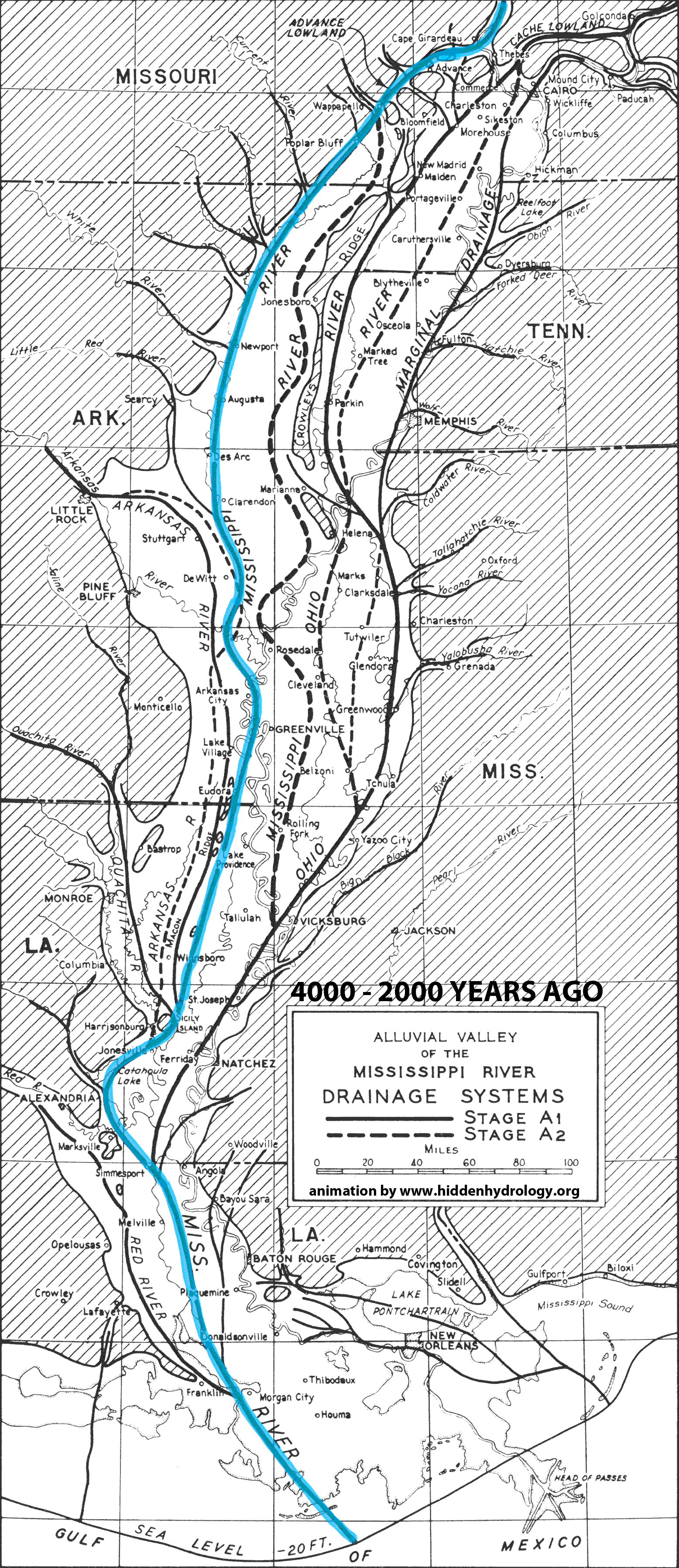
From the recent post, Indeterminate Rivers the Geological Investigation of the Alluvial Valley of the Lower Mississippi River by Harold N. Fisk offers a wealth of information on landscape change. When I first saw the series of maps the idea of showing the shifting path of the river came to mind – and I envision a much more intensive and animated idea could be applied to the color map series (from the original post) to illuminate not just the static traces but the actions of this hidden hydrology over time.
The simple animation below is based on the maps in the report that discuss the formation of the valley and the current configuration of the meanders. For reference, this map isn’t an attempt to make conclusions, but to activate some of the data represented in 2-D format in the report – showing the breadth of change of the main path of the Mississippi over the course of 4000 years of change.
As outlined in my previous post, the San Francisco Bay Area is loaded with many hidden hydrology focused activities and groups working throughout the region. This follow-up post will address the amazing depth of resources available for historical maps and other resources for mapping and exploring lost rivers and buried creeks in the bay area.
The first place to look would be the amazing Guide to San Francisco Bay Area Creeks, which has an amazing array of creek maps covering the entire region, published by the Oakland Museum of California, many of which were also funded by the California State Water Resources Control Board and U.S. Army Corps of Engineers. You can select maps or use a sort of useful Graphic Creek and Watershed Finder to select areas via map.
The site itself isn’t just a portal to information, but includes a lot of maps, historical and contemporary as well as supporting info like Creek’Zine with stories of local history, or a glossary of creek and watershed terms. Each map page offers links to the many creeks either through text or clickable smaller basin maps, like San Francisco.
This scaling linking allows for easy drilling down to subwatersheds, for instance to Islais Creek Watershed in San Francisco. you find more info and specific clickable elements,
Clicking on the map triangles yields more info – ostensibly what is found on the full printed map, but it’s nice to have really easy access to this online, in some depth. An example is found in the link to Glen Canyon:
The key shows the depth of information available, including the basins, man-made and natural drainage infrastructure, waterbodies, fill and other structures.The sidebar has keyed Historical Features, circa 1850 including ‘Creeks, buried or drained’, ‘Ephemeral creeks’ and areas that were filled.
Each map page also links to a number of historic or descriptive maps that outline water systems, topography or juxtapose the new and the old. For Islais Creek, above, a 1896 USGS Topographic map shows some source materials and evolution of the area prior to filling the historical features.
The main excerpt maps are zoomed in versions of the larger printed maps, which are pretty dramatic (in their digital form). This one showing Oakland and Berkeley areas in the East Bay. “The printed version of this map presents both the historical and modern hydroscapes of the western drainages of Northern Alameda County.”
I can stare at these for hours even though I don’t live there, that’s how fascinating they are. Click on the map to download a PDF, (3.0 MB)
An excerpt shows the detail (in this case around Lake Merritt) which is pretty representative of the maps.
I’m still amazed at the coverage of these maps, and although some are getting old, the overlay info should still be pretty accurate even in the boom of development and redevelopment happening in the area. There are maps for purchase and download, along with some GIS and KMZ files for further mapmaking opportunities. As San Francisco proper is (mysteriously?) the only version of the PDF map not downloadable, I purchased a few of the printed maps so will see how they look when they arrive in early January.
As an added bonus, I really liked this animated map showing San Francisco in 1869 and 2007. (will launch in new tab for a bigger version). This shows a simple evolution of the entire city, rotating through 150 years of change. A dramatic difference, I’d say.
An additional find was the Guide to East Bay Creeks, a brief series of essays by Sarah Pollock, Shelby Hall & Christopher Richard. Now only available online, which includes narratives for the specific hydrological and ecology – sort of a regionally specific creeks 101. From the intro:
“Throughout the East Bay city dwellers are recognizing that even in urban areas we have wildlands valuable to humans and other animals. These people are learning ecological relationships through direct experience, and they are hoping that ultimately there may be an attitude shift, a cultural recognition that even city dwellers are an integral part of a living system.”
The previously mentioned San Francisco Estuary Institute, which was responsible for some of the maps available above at the Guide to San Francisco Bay Area Creeks, and is a wealth of information on their site, both in terms of research reports but also GIS information. In their Data Center, you can search for tools, services, visualizations and other resources applicable to resilience and historical ecology among other topics. Their work extends throughout the region, but has many overlaps in the Bay Area, including the GIS data for the Alameda Creek Historical Ecology study mentioned in the previous post, and rich data sets such as The San Francisco Bay Shore Inventory: Mapping for Sea Level Rise dataset provides a comprehensive and consistent picture of today’s Bay shore (up to MHHW + 10ft) for all nine Bay Area counties. These data are available in ESRI ArcGIS file geodatabase and Google Earth KMZ format.”
Building on the last study, the SFEI folks also had a link to an awesome Historical Ecology resource, the online viewer for U.S. Coast Survey Maps of SF Bay, which provides maps of shoreline “Under the direction of some of the leading American scientists of the 19th-century, the USCS created exceptionally accurate and detailed maps of the country’s coastline. In the San Francisco Bay Area, these surveys (commonly referred to as “T-sheets”) are the most important data sources for understanding the physical and ecological characteristics of the Bay’s shoreline prior to Euro-American modification.”
The interface could use an update, but with a bit of digging the T-Sheets are available for download and are rotated and georeferenced, and includes raster and vector files. The image above I rotated and cropped – and you see that, aside from utility, these are some of the most beautiful maps. Another zoomed excerpt.
I’ve dug into the T-Sheets for the Seattle area, and they are some great maps with pretty extensive coverage. A few links provide a good tutorial, including a T-Sheet Users Guide authored by Robin Grossinger, From their summary: “This guide discusses the historical maps of San Francisco Bay produced by the United States Coast Survey (USCS) and their application to present-day environmental efforts in the region.”
There are also Seep City maps, the project mentioned in the previous post, including print maps, atlases, and a forthcoming book available for purchase from Joel Pomerantz. Another regional resource worth checking out is the Watching Our Watersheds – interactive mapping from the Santa Clara Valley Water District, which provides a good example of online interactive water tools using Google Earth. Check it out and download the data at the link.
I’d be remiss without touching on some of the cool historical map sources, including a few gleaned from the Guide to San Francisco Bay Area Creeks page, including this interactive map from the 1860s
San Francisco c. 1860 – click to open in new tab
Topographic map from the 1890s with original creeks in blue, marshes in green, and modern land fill in pink
More to come as I’ve barely scratched the surface on SF Bay area and have not fully looked at historical sources other than those mentioned elsewhere. This may be due to the amount of info available rivals most cities. Kudos to the people at working in this region for providing inspiration and great precedents for work to apply elsewhere.
And if you haven’t yet, read the first of this series – Lost Creeks of the Bay Area – Part I to learn about the groups working in hidden hydrology, art, and urban exploration.


 The previously mentioned San Francisco Estuary Institute, which was responsible for some of the

 There are also
