Another fine resource that adds to the hidden hydrology knowledge base in New York City is Sergey Kadinsky’s Hidden Waters of New York City, which “serves as a guide to the stream by tracing their development along their courses” (xiii).  The book takes a different yet complementary direction than the Welikia project and other efforts I’ve mentioned and will follow up on.  Publishes in March, 2016, the book summary via Amazon provides some context: “Beneath the asphalt streets of Manhattan, creeks and streams once flowed freely. The remnants of these once-pristine waterways are all over the Big Apple, hidden in plain sight”

Kadinsky’s day job is at the New York City Parks Department, has experience as a tour guide, also teaches and contributes to Forgotten New York, all of which provides a good context for open spaces, as well as a forum for the stories of hidden and forgotten waterways of the area.  As he mentions in the brief introduction:

“The city’s waterways have become a place where the public is reminded of nature’s presence in the city.”  He continues mentioning specifically that inland areas, where “…waterways are not as visible, having been buried beneath the streets and concealed behind building. If one searches carefully, one can hear sounds of hidden streams churning beneath manholes and see traces of them in street names that recall a water past.” (xiii).

Covering Manhattan, The Bronx, Queens, Brooklyn, and Staten Island in different sections, the breadth of the book is it’s major take-home.  Any New Yorker would be doing themselves a favor by picking up a copy and being surprised to find out that you don’t have go far to find an interesting historical place you probably didn’t know about.  The short blurbs about each area come with a variety of factoids, as well as good local destinations and options for travel via bus, subway, and bike.

The content is great, albeit brief as the book covers, as mentioned on the cover, “101 Forgotten Lakes, Ponds, Creeks, and Streams”.  The typical post gives a tour of the place, some history, and delves into some specific topics, for instance the early chapters on the Collect Pond, Harlem CreekMinetta Brook, and Canal Street (all links to the blog) provide great anecdotes about infrastructure, geology, cultural history, and the forces that led to the eventual burial of these places.  Some are hidden, others are brought back metaphorically or through places names, and many still remain hidden.  Others are more brief, with the history of the place and some brief info suffice.

A review of the book by Eric Sanderson and Christopher Spagnoli via The Nature of Cities from November 2016 entitled  “Where did all the Streams Go?”  offers a bit more context on the book from folks that are admittedly more local in viewpoint.  As mentioned: “Kadinsky’s descriptions of waters invoke the flow of time” and provide the following, which capture the nature of the stories held within the book:

“Perusing Hidden Waters is fun for both the armchair historian and the modern urban eco-adventurer. Without sermonizing, there is a distinct historical rhythm to these accounts. Most begin with a colonial description of a typically beautiful, formerly long-lasting, watery feature of the environment, many of which formed during the last Ice Age—that has been co-opted for industrial purposes. Nineteenth century New Yorkers largely regarded waterways as places to get power, launch vessels, and/or dispose of sewage and garbage. Once these ponds, streams, and other waters were fouled, the city government and private actors, on the hunt for more land to develop, filled and paved them, a process that played itself out in fits and starts from the late 19th century through most of the 20th century. The natural waters we have left now are largely the result of neglect—so little time, so many streams to fill—until the environmental movement of the late 20th century finally created the legal and regulatory tools to stop their destruction.”

Perhaps a case where the blog is better than the book as the “companion blog for the book ‘Hidden Waters of NYC’ provides more room and allows Kadinsky to venture beyond the format the book constrains him to both geographically and visually.  For me the depth of information in the book pales in comparison and seems lacking in what Kadinsky covers in the blog, with more informal stories and visuals.  As a field guide, it seems a bit too text heavy, and lacking in really good contextual maps where one could follow along and tour through the narrative in a way that allows the story to unfold. This may be more a personal preference, however, the the overlay of new/old is fundamental to engaging with this type of historical ecological information, perhaps best addressed by the compelling map visuals of the Welikia Project.  Although it’s available on the blog, it is the one thing sorely missed in the book.

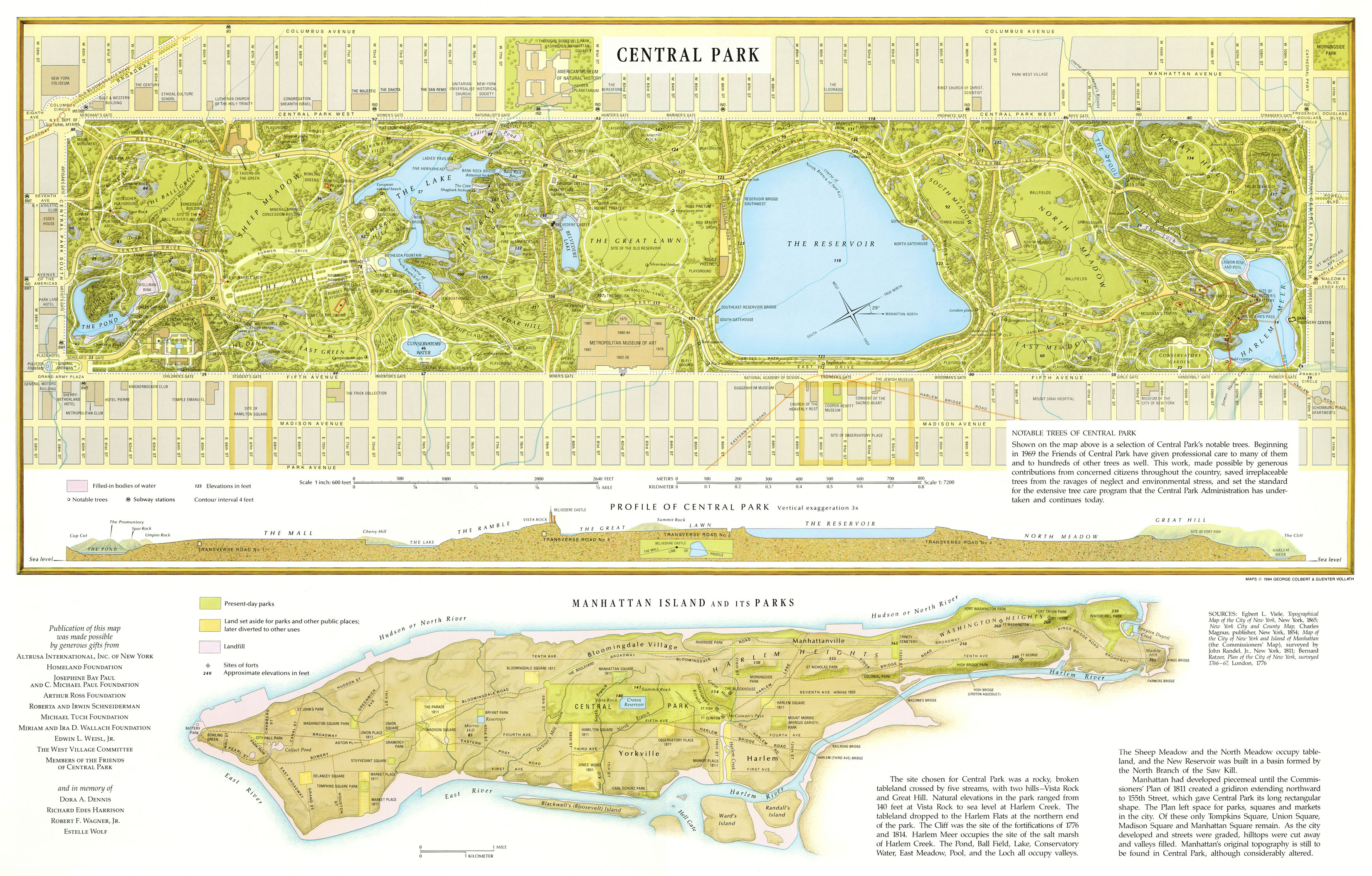
The notable narratives that I’ve read on the blog are many, but include a fascinating account of Robert Frost’s 1923 poem ‘A Brook in the City’ which recounts Minetta Creek,  a post recounting some Map Oddities, some cool examples of interpretive paving on Broad Street, the many posts about Central Park, many more I’ve bookmarked.

He also includes a two part reading list with some great additions to the local and broader context, including connections to Stanley Greenberg and others beyond the realm of water.  In highlighting the book I’m aiming to showcase what i think is a great contribution, namely writing about hidden hydrology, and also to provide some thoughts about what works in curating and narrating these stories of place.  It’s hard to capture in book form, the spirit of what is lost, the history of then, erasure, time and what is still there (a dilemma faced by much of the hidden hydrology literature).  In the end any text that endeavors to do so needs maps,  and lots of them, to support this effort.

Read the blog and follow him on Twitter @SergeyKadinsky and you’ll see more of this great example of a passion for place and hidden hydrology that connects people to their home places, Kadinsky’s book and blog aid in this.  He mentions this connection in the intro, and his work helps make true that “inland waterways today have resumed their role as vital elements of the city’s identity; providers of a sense of place.”


Header image: 1994 Greensward Foundation map of Central Park from this post here.


A brief aside to contemplate the concept of hidden hydrology, both as a subject of study and as an agent for change.  While I’ve been inspired by the concept for some time, I’ve only recently tried to formalize this, collecting information and starting this blog in September 2016.  Call it my doctorate in Urban Studies that I never finished, happening over the web, with little to no outside supervision, mostly in my free time from 10pm to the early hours of the morning.

I get mixed reactions when I mention the project, spanning a sort of incredulous ‘Why?’ to an excited “Wow!” with all variations in between. This concept is indicative of the root of my own journey and sometimes my struggle, being simultaneously inspired while trying to figure out what to do with information.  On one hand, is just endlessly fascinating (others would agree), and my information gathering, generalist nature wants to find every detail there is to find. And while having an extensive collection of notes, images, maps and resources on my computer is satisfying in a way,  it does lack a certain sense of purpose.  On the other hand there’s sort of a perceptual disconnect with why any of this matters amidst the plethora of contemporary issues, and my productive landscape architect, designer, urbanist, cartogaphic, activist & ecological nature wants to connect this historical ecology to the greater issues of regenerative strategies of place.

Thus the tagline I originally came up with is a shorthand for both a duality that hints at both potentials, and I think still inspiring:

Exploring lost rivers, buried creeks & disappeared streams. Connecting historic ecology + the modern metropolis.

Sometimes it just takes a while to figure out what an end game can look like, and you have to dive in and see where it takes you.  I’m calling this, in the spirit of hydrological study, the Meanders, as I’ve titled this post, and it’s been fun to see it played out in presentations, dialogue, and writing with not really a set purpose or goal.  I’ve had in my mind, beyond the blog, a book or series of books, perhaps which could be historical, design or urbanism or something spanning all.  Also I have toyed with the idea of online atlas, an exploratory video game, a series of historical images superimposed on modern scenes, art installations, tours, and much more.  I’m still working on the specifics of where it may lead, but realize it’s not one destination, but many.

At a foundational level the study will focus on Seattle and Portland, as a locus of study and between the two, a venue for comparative analysis and places I live and know well (and have easy regular access to).  While both are Pacific Northwest cities that were founded around the same time (1850s), their evolution and histories diverged much due to geography, topography, and hydrology, with Portland built around rivers and Seattle shaped as a city tied to the oceans and lakes.  Beyond this obvious dichotomy, there are a number of differences which will be part of, and perhaps fundamental to, the study.  One of which is notably politics, which tends to shape place as much or more than those ‘natural’ forces, played.  Maps of the two show the unique differences, and the ‘blank’ slate to be filled with oh, so much potential.

PORTLAND

SEATTLE

Thus the core will expand around these cities, and include a continual focus on Explorations, walking, recording, and connected with the experiences of what is gone and what still exists.  The goal is to walk/map/explore every hidden stream in each city, and use this along with mapping and history to provide a documentation of hidden hydrology.  While the focus will be on these two cities, there is so much information to bring from the wider base of knowledge that allows the analysis to be well informed.  Seeing the immense depth and breadth of information that exists and all the forms it can take (which hopefully you’ve seen in these posts), there are ample bends and side channels for us to navigate – but the focus on these two places allows for focus energy for generation specific to place.  This hopefully alleviates the danger of just continually searching and compiling information without acting.

In that vein, as precedents, in the past year, I’ve posted summaries of many cities focusing on hidden hydrology, including posts that study the inner workings of cities like Indianapolis, Los Angeles, Washington DC, Philadelphia, San Francisco Bay Area, Rome, Vancouver, Toronto, as well as both Portland and Seattle. to varying degrees. These are the the dozen or so “core cities”, which, along with New York City and London you’ll see in a bit, which have the most fully expansive studies ongoing for hidden hydrology.  Each have activities and viewpoints that are specific to place, but all are tied together with connections between water, then and now.

Image of Rome – via Katherine Rinne, Aquae Urbis Romae

I’ve also touched on other areas around the globe, including Boston, Lexington, Munich, MontrealMexico City and Venice, and will continue to offer smaller snapshots of other communities, as there are literally hundreds of fascinating stories to tell.  These studies show a wide range of activities these projects take on, including art, tours, literature, advocacy, history, ecology and more, as well as the broad geographic reach of the concept of exploration, in its many forms, of hidden hydrology.

There will be many more posts to come come from all of this, but I wanted to add the two cities that have by far the most expansive and inspiring hidden hydrology efforts I’ve discovered to date: New York City and London.

New York City is one of the inspirations I’ve mentioned, with the Mannahatta project a lofty goal of mine to apply to my own home places, and the work done by others to document the hidden hydrology of the New York region is phenomenal.  I’m looking forward to sharing more of this.

Mannahatta Visualization

And London, perhaps more than any other city, has been so well documented in terms of hidden hydrology, with countless books, maps, ruminations, explorations and more, each with a unique viewpoint and much rich history to draw from.   Over the course of the next few weeks, I’m going to take multiple posts to sum this up with New York, as there’s a lot to cover.

A Balloon View of London, as seen from the north – via the British Library

Additionally, beyond continuing to document places as precedents, there are a bunch of fascinating topics which enrich these spatial stories, and also inform my own activities.  I’m constantly inspired by artists using hidden hydrology as a medium, so will continue to include more examples, both site specific, and including techniques around soundscapes.

Light Meander – River based sculpture in Nashville by Laura Haddad & Tom Drugan

The literary connections of historical waterways is worthy of discussion also, as another of the key inspirations come from both David James Duncan and Anne Whiston Spirn.  The connections to language and place names that span cultures, and a thorough acknowledgment of colonization and appropriation is an important aspect of any historical endeavor. Mapping as a subject is vital to this study, including historical ecology and methodologies for mapping that uses new technologies to connect old and new and display these connections in inspiring ways.

Rectangular world map from Fatimid treatise, Book of Curiosities of the Sciences and Marvels for the Eyes, copy of manuscript originally written in the first half of the 11th century

The ecological and the hydrological are at the root of rivers, creeks, streams and watershed, providing a context for understanding the past and the present in terms of something this is ever changing, blending soils, geology, climate, ecology and understanding of aquatic systems to infer the historic and investigate opportunities for historical baselines as a metric for regeneration.  This requires understanding the potential to restore, but also moving beyond ideas of daylighting as the only option we have, with a more nuanced and historically informed continuum which integrates, culture & art, ecology & habitat using design and science– restoring the key functions of urban streams in a form that evokes, mimics, and celebrates, but doesn’t rely on pure restoration for the original creeks.

Stories of place and process, maps and images, people and words, all aggregate, some sifting through and precipitating in eddies, others taken downstream by the force of the flow.  Then again, all this could change.  A meander overtopping its banks and connecting with another flow, carving out a new channel, or disconnecting and spinning idly in a lonely oxbow, driving via gravity in tension against rock, all the while creating life at its margins.  Not a bad metaphor for a creative process.

The flow may have some direction now, but the nature is still, always, to meander.

A quick visit to Portland this weekend didn’t feature much in the way of exploration, but it was a pleasure to stumble upon the Tanner Creek Tavern, a new restaurant in the Pearl District (corner of 9th and Everett) with a nice connection to hidden hydrology.  The name says it all, but the spot has the distinction of housing some notable historical remnants celebrating Tanner Creek, including some maps and photos of the creek, which ran nearby for many of the early years of Portland’s history before being encased underground in the early 1900s.

The far wall of the restaurant contains a 1870s aerial lithograph of downtown, viewed from the east across the Wilamette River, with the ‘route’ of the creek highlighted in a faint blue.  Some questions arise about the fidelity of the tracing of the mouth of the creek, but it does aid in reinforcing Tanner Creek.

photo – Jason King

Oddly enough, I’ve collected other versions of this map that are not as crisp of a reproduction (it typically comes with a chunky border and is oddly cropped on both sides, but hadn’t seen this particular one, via a link on their website gallery as well., which is beautifully shaded with the wooded West Hills up from the nascent downtown grid and a sparsely filled in east side.

Birds-eye view of the City of Portland, Oregon. Photo file #1924-b

There’s some references to the creek history on the menu, and a bit of a longer text via the website, a sidebar on the Legend of Tanner Creek:

“Tanner Creek was named after the tannery established in 1845 by Kentucky settler and Portland founding father, Daniel Lownsdale. With its headwaters originating in the West Hills, the creek traced its surface path down Canyon Road and through Goose Hollow before emptying into Couch Lake and the surrounding wetlands that now make up the modern Pearl District.  Portland’s heavy storm runoff would often cause the creek to overflow, damaging property on the expanding Westside. City fathers tackled this problem in the late 19th century by burying the creek in an enormous brick-lined culvert excavated at some points to a depth of 50 feet.  Today this subterranean public works project still functions much the way it did over a century ago. The creek meanders below the Pearl on its final destination to the Willamette River where it empties somewhere between the Broadway Bridge and the Portland Police Horse Paddock.”

A few other views show the space, an airy semi-industrial central bar surrounded by open seating with some wood accents.  A really loved the central visibility of the map as the focal point.

Image via Tanner Creek Tavern

Another wall visible from outside has photos of the demise, a set of 1920s era construction photos of the installation of the pipes that took the surface waters underground.

photo – Jason King
photo – Jason King

While I am probably same in assuming I was the only one in the place geeking out on a giant wall map of a hidden stream, it’s a decent attempt at connecting a place to place and imbuing a story into what are often sort of hollow legends that are crafted for bars and restaurants in lieu of real context. And, hidden hydrology nerdiness aside, the food and drinks are pretty good as well.

In my journeys investigating hidden hydrology I stumble upon some interesting side projects that fit nicely as a complement to the idea of buried creeks and lost rivers.  While the main thrust of the project is on these lost rivers, the parallel of the unseen in terms of infrastructure systems led me to the work of photographer Stanley Greenberg.  A short interview as part of Urban Omnibus series Unseen Machine entitled Stanley Greenberg: City as Organism, Only Some of it Visible piqued my interest.

The interview, which is from 2010, discusses some origins of Greenberg getting into photography, as well as the way of looking at the city in new ways.

“I think the city is a huge organism, only some of it visible, and we inhabit it, change it, get changed by it. But there is so much of it that I don’t know. I have mental maps of some neighborhoods; others I still need to explore. There are New Yorkers who never leave their home neighborhood. I try to get out and see as much as I can; walking, on my bicycle, in the subway. And I am always reading about the city, present and past. I suppose I treat it more like a tourist would, always looking for new things and hidden old things. I’ve learned to look for different kinds of subtle landmarks; where are the water tunnel shafts, for example, and how they affect a particular landscape. Or how different eras are marked by manhole covers, lampposts, width of the streets, other urban artifacts. I’m a birder, so I’ve trained myself to look at details. But it’s the same with the city; you always need to be looking. I think it’s important not to take it for granted. That’s what I try to do with my pictures; convince you that it’s worth your time to look at the city, maybe in a way you hadn’t before.”

The concepts of infrastructure also is juxtaposed with discussions of access and security of these system.

Greenberg mentions that he had good access at the time, but that the ideas have changed: “I’m saddened that so many of the places I photographed for the first two books have been removed from the public’s eye. I still think that when there’s more public access, places are safer, for a number of reasons. Neighborhoods, for example, are always safer when more people are outside and active. You can’t possibly police all sensitive locations, and you have to have the public take ownership of its property seriously. I haven’t trespassed (much) to get pictures, since my equipment doesn’t allow for it — and in most of my projects, I haven’t needed to. But I support the idea that sometimes the public’s right to know trumps rules of access.”

There I also learned of the books Invisible New York: The Hidden Infrastructure of the City and Waterworks: A Photographic Journey through New York’s Hidden Water System, both of which seemed to fit the theme nicely.

For you BLDGBLOG fans, Geoff did a profile in 2006 here worth checking out, and a bit more of Greenberg’s work is available on his website, for instance, some shots in the ‘Infrastructure’ category below:

The photographs are, as you can see, typically black and white, and tend to focus on the architectonic, which is perhaps more about the subject than the photography itself.  One interesting photo is from Fresh Kills Landfill in Staten Island, taken in 1993 before the eventual design competition and ongoing multi-phase redevelopment into Fresh Kills Park

Greenberg mentions: “I photographed Fresh Kills landfill for the book (though the pictures were not included) and then again as a commission just before the design competition started. Some places are transformed while using their history in an interesting (and often more subtle) way. Others become simulacra of what was there before, and are much weaker because of it.”

There’s also some interesting recent work on Button Agreement (a project that includes walks of Manhattan, water tunnels in NYC, and explorations of water and cities) which incorporates some earlier work on Water Log, which looks at “Water infrastructure: water supply, aqueducts, dams and dam removals, canals, locks, and other related structures and sites”

Again, the content is diverse, but includes some color photography, and delves a bit into .  The photo below is from work on the “Lake Superior, Part 1″ and is captioned: “Storm Sewer (and trout stream, Duluth, Minnesota” connecting squarely to hidden hydrology.

The more subtle, comes in the form of walks (with some simple hand-sketched route maps included) following infrastructure systems, such as “City Water Tunnel No. 3 Ventilation Towers”, which has multiple shots of towers woven through the city, highlighting the subterranean path by pointing out features that would probably go unnoticed by the average urban dweller.

And closer to my neck of the woods, the photographs of the Elwha Dam removal on the Olympic Peninsula, “Elwha River, 2010-2014″ are great, showing some evolving imagery of areas as the dams were decommissioned. 

Lots more exploration here, but the concept of hidden hydrology has orbits that transect the infrastructural is embodied in Greenberg’s photography.  By looking deeper at cities and the subsurface elements, we can provide a beautiful connection (often even just the mundane becoming visible) to these lost, buried, hidden, yet still vital systems.

Another city doing some great work around Hidden Hydrology is Toronto. Featured in the Lost Rivers documentary, the city boasts as range of resources and groups worth some exploration.  A plethora of media fuels the fascination, with numerical and witty titles, including “5 lost rivers that run under Toronto“(blogTO), “5 subtle signs of lost rivers in Toronto” (Spacing Toronto), “Toronto’s ‘lost rivers’ reflect how we’ve reshaped nature“, and “Toronto’s Hidden Rivers” (Toronto Star), “Last seen heading for the lake” (The Globe & Mail),  In particular the author Shawn Micallef a colunmist from the Toronto Star that has looked at disappeared creeks, and lost creeks.  The more general discuss “and “What the Toronto Waterfront used to look like” and connect to the online archive of Toronto Historic Maps and other resources.  The following explores some of this in more depth.

Hidden Hydrology Resources & Groups

Lost River Walks is a long-standing resource in Toronto, “The objective of Lost River Walks is to encourage understanding of the city as a part of nature rather than apart from it, and to appreciate and cherish our heritage. Lost River Walks aims to create an appreciation of the city’s intimate connection to its water systems by tracing the courses of forgotten streams, by learning about our natural and built heritage and by sharing this information with others.”  They include a number of Stream Pages, accessible through the Site Map, which provides history of individual streams, in this case, The Market Streams, which highlights a series of streams and provides some overlay mapping of the current sewer network.

Location of Lost Rivers


Location of current sewer system

The engagement is a key part of the group, as the name implies, through a series of guided walks, which highlight lost rivers and creeks  in the context of the urban fabric, as well as focusing on topics like water quality. There are also self-guided tours ‘Thirsty City Walks‘, provides opportunities to follow the former and current routes of waterways. A map below shows the route of the walk with key points and audio commentary as one follows the route.

A great bonus article I found on the Geohistory-Géohistoire Canada Project, authored by John Wilson entitled “The Lost Rivers Project: The Case of Holly Brook“.  This post outlines some of the process, in particular the need for ground truthing, as he mentions, “I have spent many hours travelling the city’s streets and laneways looking for signs of lost rivers and ravines. My street-level observation of Holly Brook’s course was simple – whatever the City Engineers may have drawn on 1890s maps, water doesn’t flow uphill!”  Lots of great stuff at Lost River Walks, so check out the website, and follow them on Twitter @LostRiversTO and also via founder and lost rivers force Helen Mills at her account @HMMLostRivers

Vanishing Point is the brainchild of Michael Cook, a resource of which “…emerged from a decade of underground research and photographic practice”.  The varied topics include topics of Daylighting Creeks, Parks and Stormwater Spectacles, Lost River Activism, and Celebrating Infrastructure Projects .  Cook continues, describing the work as ” a form of citizen geography, it has informed community groups, academic projects, and the official work of planners, landscape architects, engineers and archaeologists.”  This sort of comprehensive resource adds to the work of Lost River Walks with information and a wealth of interesting photography.  Lots to check out here, and also worth following Michael on Twitter @waterunder

The Don River Valley Historical Mapping Project is (was) a robust exploration of the Don River, “This project documents historical changes in the landscape of the Don River Valley. Drawing from the wide range of geographical information available for the Don River watershed (and the Lower Don in particular), including historical maps, geological maps, fire insurance plans, planning documents, and city directories, the project uses Geographic Information Systems software to place, compile, synthesize and interpret this information and make it more accessible as geospatial data and maps.”  It’s hard to tell if it’s still active or just the website hasn’t been updated, but most info stops in 2010, but still some great geospatial data, resources, maps, and other information related to the Don and larger Toronto hydrology.

A new? interactive map of the project provides spatial information to complement the work to date, and offers a way to interact with the data in new ways.

Another interesting take on how to use different methods for displaying the subject matter comes from Alex Meyers project “Uncovering the Creek“, a timeline that provides a “…study of the city’s changing landscape through a close examination of Trinity-Bellwoods Park and the Crawford Street bridges. This project is a virtual excavation of a hidden Toronto landmark that has been almost erased by the process of city building.”  A nice method of using a linear timeline with links to graphic resources and maps.


Additional Resources 

The group Human River was featured in the Lost Rivers documentary, and was featured doing an interactive walk, “during the annual story telling parade, participants wear blue becoming a human river and bringing the Garrison Creek back to life”.  It’s a cool way to use event to raise awareness plus looks like a lot of fun. It also looks like their website is both abandoned and hacked with lots of spamming links – so i grabbed this image quickly and then ran.  Not sure the current status.

Also mentioned in the Lost Rivers documentary, the Garrison Creek Demonstration Project by Brown & Storey Architects (from 1996!) envisions the use of the Garrison Creek zones for green infrastructure, positing that “… the existing natural watersheds, like the Garrison, can be used as sites for stormwater management pond systems. Not only can these connected pond systems serve to collect, treat and re-use stormwater locally, they can also act as a catalyst in the creation of a series of connected open spaces knitting both an urban and green infrastructure back to the waterfront to Lake Ontario.  The study documents several aspects of the Garrison watershed: the considerable amount of open spaces, their area and type, geological formations, existing storm water infrastructure underground, the areas of fill along the ravine path, and an abstracted locational plan for water retention ponds.”

A walking map of Garrison Creek evokes the story of the plans above, and multiple posts about Garrison Creek and a Discovery Walk also focus on Garrison Creek,

The Garrison Creek route is also referenced with some cool markers, as seen below:

Some additonal links include the Taylor Massey Project and Lost Creeks of South Etobicoke both smaller scale projects highlighting areas of Toronto lost creeks.  Also, more recently, Trevor Heywood posted a long series of walks on Twitter, with his explorations around the Yellow Creek, showing that the passion for exploration of Toronto hidden creeks is alive and well.  On that note, few more interesting images in the form of murals, first posted by @SheilaBoudreau of a Lost Rivers mural I’ve seen a bit; the second a map, posted by @tashmilijasevic both locations unknown to me but i’m sure folks in the area know where they’re at.


A Photographic Abundance

Photographers become drainers seems to be a theme in many cities.  In addition to Michael Cook from The Vanishing Point mentioned above, another photographer focusing on underground Toronto is Jeremy Kai, (Twitter @RiversForgotten   From his site: “His underground photography explores the concepts of urban watersheds and the methods in which cities interact with water and waste water. These processes go mostly unobserved by the general public. Kai hopes that by documenting the city’s lost rivers and overlooked spaces beneath the streets, he can awaken a new sense of mystery and mythology in the minds of urban dwellers everywhere.  His first book, Rivers Forgotten, is published by Koyama Press. It was released December 2011 and features his underground photography”

In a different bent is a recent exhibit entitled ‘Nine Rivers City’, From the site: “From west to east, nine rivers feed into Lake Ontario. View a map of the rivers here.  Harbourfront Centre has commissioned six contemporary visual artists to capture the complexities of each of these waterways that run throughout our urban landscape. Situated against the shoreline of Lake Ontario, NINE RIVERS CITY showcases how these extraordinary waterways connect us, attract us and mystify us.”  A clickable map showcases photographs spatially, such as Aaron Vincent Elkaim’s HWY 401 below:

The Don River East branch flows below the King’s Highway 401, also known by its official name as the Macdonald–Cartier Freeway, near Leslie Street by Havenbrook Park. The Don is formed from two rivers, the East and West Branches, that meet about 7 kilometres north of Lake Ontario.This section of Highway 401 passing through Toronto is a near constant river of cars, and is considered the busiest highway in North America.

Another take on this is Kathy Toth, who formerly had a page on her website ‘Watercourse (Buried Creeks)’ which seems to have been taken down, but does delve into the subject matter with her Hidden Toronto work, which aims to be reprinted soon.  Per her page: “The first edition of Hidden Toronto featured a selection of hidden infrastructure locations in Toronto, including bridges, drains and rooftops where graffiti has sprung up. Many of the locations are off the map and can be found with some searching or luck. Some of them are right downtown under foot, others are on the edge of greater Toronto area. I decided to showcase these spaces, and the artwork painted on them because they exist in an extremely narrow circle of composed of graffiti artists, a few photographers, and the odd individuals who either live in the surrounding areas. These environments have a unique character and the artists who work here take advantage of the serenity and isolation afforded by these surreal landscapes sometimes just 100m away from busy roadways.”

Can massive computing power and artificial intelligence crack the code of deep history of places? This is a fundamental question of a project discussed in an article on nature.com “The ‘time machine’ reconstructing ancient Venice’s social networks”. Frédéric Kaplan plans to “…scan documents including maps, monographs, manuscripts and sheet music. It promises not only to open up reams of hidden history to scholars, but also to enable the researchers to search and cross-reference the information, thanks to advances in machine-learning technologies.”

The Venice Time Machine can link citizens and businesses with historic maps of Venice, such as this sixteenth-century view of the city. Credit: EPFL/Archivio di Stato

The goal is to crunch enough data to outline the connections that emerged in historical societies including “social networks, trade, and knowledge”.  While of interest to historians, it could also inform economists and epidemiologists, as well as other disciplines.  Much like Rome, Venice, mentioned as “The Serene Republic“, is a good for this endeavor due to the wealth of knowledge and its organization, aided by its protected lagoons and it’s desire for documentation.

“As Venice’s empire grew, it developed administrative systems that recorded vast amounts of information: who lived where, the details of every boat that entered or left the harbour, every alteration made to buildings or canals.”

While there was been study over the years, much of the archive “…predominantly written in Latin or the Venetian dialect, has never been read by modern historians. Now it will all be systematically fed into the Venice Time Machine, along with more unconventional sources of data, such as paintings and travellers’ logs.”

Kaplan’s interest has been to employ AI for lingustics, so the concept of using machine learning to study patterns in language is fundamental to the work, along with digitization of many thousands of pages of documents, building on work already done by the Italian Ministry of Cultural Heritage.

There’s a lot more about the linguistic ‘hacking’ of documents, as illustrated below, but the concept also involved diving into the archival cartography.   “In 2006, a huge, purpose-built scanner began to digitize the archive’s precious store of more than 3,000 maps of Italian towns, including many commissioned by Napoleon. These ‘cadastral’ maps delineate property boundaries and record the ownership of small parcels of land; some of the documents are as large as 4 metres by 7 metres.”

The result is the ability to create some amazing detail with overlay of multiple sources:

“One cadastral map of Venice that he commissioned in 1808 has provided a backbone of reliable data, allowing historians to add geographical context to a 1740 census that lists citizens who owned and rented property in the city. By combining this with 3D information about buildings from paintings such as those of Canaletto, the time-machine team has produced an animated tour through Venice, showing which businesses were active in each building at the time.”

A video on YouTube outlines the ambitions of the project.  From their summary:  “The State archives of Venice contain records stretching back over a thousand years. The vast collection of maps, images and other documents provide an incredibly detailed look into Venetian history. This could be used to create a kind of virtual time machine for historians and the public to explore the city.”

What implications does this have for hidden hydrology?  To me, the overwhelming task of both digitizing information and determining patterns is something that is daunting for a team of professionals, much less individuals looking to glean discoveries from their local place.  The sheer effort and technology in digitization and analysis could be employed to discover key linkages and patterns that may illuminate historical hydrology, topography, and other clues.  An example mentioned in the article highlights the concept, using animations to look at spatio-temporal change , in fact “One is a dynamic video of the development of the Rialto from AD 950 onwards, using diverse sources of information at different time points. The simulation shows how the buildings — and the iconic Rialto Bridge — sprung up among the salt marshes, along with the area’s periodic destruction by fires and subsequent reconstructions.”

The possibilities with large data sets is intriguing, and the article mentions cross-disciplinary opportunities, as well as larger connections to other ‘time machines’ in cities, such as a new effort in Amsterdam and possibilities in Paris.  It adds a dimension of big data as a potential avenue for exploration, yet is tempered by age-old techniques and cautions of the next shiny object.

“The unbridled ambitions of the time-machine project are a concern for some researchers, not least because many of its core technologies are still being developed. “The vision of extending digital representation into different time slots is absolutely, self-evidently right — but it might be better to develop things more in a lot of different, small projects,” says Jürgen Renn, a digital-humanities pioneer and a director at the Max Planck Institute for the History of Science.  Nevertheless, Daston suspects that the time machine heralds a new era of historical study. “We historians were baptized with the dust of archives,” she says. “The future may be different.”

Header image via: nature.com

The first of what I hope are many field trips and investigations is now up on the site in a section called Explorations.  This will be the location for these site-specific journeys, and will be augmented with maps, narratives, soundscapes, and images layered to tell the Water Stories of these hidden streams and buried creeks.

For this initial foray, in Seattle, it was immense fun to wander the areas north of Green Lake and discover the history of Licton Springs. As you see from the map below, the historic routes show a stream flowing southwards into Green Lake.  The reach of the waterway starts around Licton Springs Park, where it is sees daylight for a stretch, along with some other intermittent segments where it pops up in surprising ways, throughout the neighborhood.

The story of Licton Springs focuses on the significance to Native Duwamish peoples, who celebrated the place and it’s spiritual, reddish, iron-oxide infused waters, and to early settlers, who lived and recreated, bathed in thermal pools, and bottled and drank of the healing mineral waters.

Like many places, the history of how the place evolved and how it was maintained is of interest, but the journey of the now and the experience of a day of exploring the edges, the muddy margins, and the sloppy seeps (lost shoes included) connect the history of place to the experience of today.

Beyond the park, there are a number of other discoveries that paint a story of people and place woved together through the flow of water.  Discovery of the story of Pilling’s Pond, a small section carved out of the flow of Licton Springs to provide a sanctuary where Charles Pilling became a world expert duck breeding in the middle of Seattle.

The discoveries also include a unique segment of stream fronting Ashworth Avenue,  a single residential block with driveways and fences literally bridging over the final daylit segment of of Licton Springs, showing how each owner shaped, or left feral, their little piece of the wild.

The connection as well with the virtual, with the final connection is made to Green Lake.  Now only connected via overflow, the tracery of Licton Springs, imagined perhaps in some abstracted water play forms, swales, and cascades, may still be allow the creek to be evident, if only in our imagination.

The link below expands on this summary, so check it out, go out and explore, and come back with some water stories of your own.

READ THE FULL EXPLORATION OF LICTON SPRINGS

Save

Save

Save