Dublin is another city with a rich history of lost waterways, so as a quick follow-up to the previous post about Belfast, let’s keep the focus on Ireland for a bit longer. The best source for this is a great article by Arron Henderson, “The Poddle and Dublin’s Hidden Rivers“, which mentions that there were over 60 watercourses flowing at one time. While a few remain such as the Liffey, Dodder, Santry, and Tolka – most are either completely gone or mostly underground. Henderson focuses on the Poddle, “…which runs underground for the majority of its course.”
The Poddle flows under Bridge and over a Weir at Mount Argus (via Dublin)
He points of the importance of these hidden streams, and how learning about them can connect with the history of places, sometimes in the margins, and often long erased from memory.
“It’s clear the Poddle played a crucial role in shaping Dublin’s history over so many hundreds of years. Providing our drinking water, powering mills, providing water for brewing, tanning, distilling and market gardens. This explains why, once they learn about it, people tend to treat this modest little river with interest and affection. An affection which is, after all, no more than it deserves.”
The River Tymon/Poddle near its source, as it flows out from Tymon Park – (via Dublin)
As mentioned in the article, there are many other hidden rivers, including the Swan, and place names emerge, with stories about the shopping center named after Rathmines, one of the tributaries of the Swan. Also some etymology, like the suffix “-iken” which means small, and one of Dublin’s rivers named in homage of another larger river named the Nanny, becoming it’s smaller namesake, the Naniken River.
For some exploration, there’s a map that I found, but can’t figure out the author, showing “dublin river past present and culverted“. A snapshot of the map is here, but it’s explorable via the Google map. Many of the waterways are untitled (and perhaps unnamed), but some are identified. Let me know if anyone knows the creator of this one.
Similarly, this leads to opportunities for students to explore and learn about these hidden local waterways, as shown in this story from Dublin People, “Students explore hidden Northside waterways” and The National Neighborhood efforts to connect school kids to this hidden hydrological history. ” Led by artist Claire Halpin, the students are investigating the hidden rivers of Finglas and the Tolka river valley, and with the help of the National Museum of Ireland Collins’ Barracks Education team, are getting a chance to see first hand how their ancestors got around on the waters of north-west Dublin. “
“Already they have been learning about the secret underground river, Finglas Wood Stream, which flows right beneath their school. “
For further exploration and information, this video from Urban Tales RTÉ One has a good story about Dublin’s Hidden Rivers, covering the history of the rivers, mapping, and even a little subterranean exploration. Worth a watch.
MAPS
There’s great resources via the Ordnance Survey Ireland and a great collection of 19th Century Historical Maps – check out the link to find more like these for areas all over Ireland.
A recent article on Belfast’s River Farset jogged my memory that I’ve got a ton of great info the hidden rivers in many cities around the world, so figured I’d start writing about them. For this post, I’ll focus on Belfast, and return shortly to discuss Dublin to round out Ireland, then move on to other locales. As mentioned in the most recent article, “For 170 years, the river that gave Belfast its name has been buried underground in a hidden tunnel.” It goes on to discuss how, similar to many stories of cities worldwide, the river was slowly changed from vital aquatic resource that fueled manufacturing such as linen mills, to it’s transformation as dumping ground, leading to the eventual encasement: “One million bricks and 40 years later, the last section of the Farset that flowed through the city centre was buried underground in 1848, and it has remained hidden from sight ever since.“
In the 1800s, the Farset helped to power Belfast’s textile mills, factories and distilleries PHOTO: De Luan/Alamy (via Daily Trust)
From the article:
“Belfast, or Béal Feirste (‘the sandy ford at the mouth of the Farset’, in Irish) not only owes its existence to this river, but also its growth and early prosperity. Yet, for the last 170 years, this ancient waterway has been sealed off from the outside world by a series of tunnels, and is largely forgotten by those walking just above it.”
The desire to open up the Farset is a common theme, with plans “…to redevelop land around an exposed part of the river and also produce a full heritage package – including an exhibition, Farset app, public information signs, and tours with trained guides – that will highlight the heritage to local people and also attract tourism.”
Another article echoing this sentiment in the Belfast Telegraph traces “The lost river that gave Belfast its name” and offers an exploration as well: “Old drawings show a bustling river which powered Belfast’s industrial development and ferried traders into what is now High Street. But most locals would be hard-pressed to pinpoint exactly where the Farset flows before it reaches the city centre – because almost the entire route is now hidden beneath our feet in the form of culverts. The Greater Shankill Partnership recently revealed it wants to transform one of the few open stretches of the Farset into a public amenity as part of its long-term Shankill Greenway plan.”
Tracing the source of the Farset river in Belfast from the hills over looking Belfast to its end at the Lagan Weir Shankill cemetery where the river behind – image via Belfast TelegraphTracing the source of the River Farset in Belfast: river ends at the Big Fish at Customs House Square –
This similar theme is expressed in stories from 2015 from the BBC, “Hidden History of Belfast’s lesser-know rivers brought to the surface”, which includes the Farset, as well as the Blackstaff rivers, both of which “determined the shape of the city that grew up around the narrowest bridging point of the Farset, where High Street is today.”
A computer image showing the original course of the rivers Farset and Lagan in Belfast – via BBC
Additionally, the Connswater, which was featured in Van Morrison’s song “Brown-Eyed Girl“, but also has a larger history as a locus of whiskey production, ” In Victorian times, two-thirds of whiskey exported from Ireland came from Belfast, and around half of that came from two distilleries – the Connswater distillery and the Avoneil distillery. “ Today, remnants run under the 400-year old bridge in east Belfast. Portions of the river runs through Orangefield park and supports wildlife, “The river used to run along fences at the back of the houses, which were susceptible to flooding. Instead of building floodwalls, here the river has been ‘moved’ to become a central feature of the park.”
The 400-year-old Connswater Bridge in east Belfast – via BBC
HEADER: Partially hidden view of River Farset in Belfast – via Belfast Telegraph
Building on my recent post about the anniversary of the catastrophic flooding of Vanport, I had the opportunity to visit some of the events at the Vanport Mosaic Festival from May 25-June 5. One highlight was a series of tours being offered as part of the events on Memorial Day weekend. The tour started at the Portland Expo Center and looped through key areas of the site, and it was exciting to get access to a few areas that are typically off-limits to people on a regular basis. It was also available as a self-guided walking tour, so they had maps for referencing key Vanport locations overlaid with current conditions
Vanport Tour Map (via Vanport Mosaic)
The back side of the map is supplemented with imagery of sites along the route, giving a feel for what it was like during the height of Vanport. It’s interesting to see these spaces and activities from 70 years ago, and for the most part discover that few traces of this still exist on-site.
Vanport Tour Map (via Vanport Mosaic)
The tour took a bit over an hour, and was led by Clark College professor of geography Heather McAfee, who layered stories and facts onto the tour, and demonstrated a passion for the need to tell the stories of Vanport more widely. While I wished we were able to hop out and explore a bit more, there were a few stops along the way, including this kiosk at one of the parking areas.
A Place in Time Called Vanport – Kiosk
The trail adjacent to the site led Force Lake, one of the amenities of the original Vanport community that was formerly adjacent to the original Recreation Center, and had beaches at the margins. The perimeter is now overgrown and a large wetland zone that is mostly inaccessible except from some narrow paths or to golfers on the west side.
Force Lake
Those other uses are a part of the story. South of the kiosk is a good orientation to the current land use of the majority of the Vanport site today with the western portions occupied by Heron Lakes Golf Course and portions of the east side of the site occupied by Portland International Raceway (PIR), making most of the site not publicly accessible.
Heron Lakes Golf CourseTrack at Portland International Raceway (PIR)
Both of these uses contribute to the lack of remnants that remain from the original Vanport site. As our tour wove between the two atop short levees, we struggled to look from map to site and make any meaningful connections, so disconnected these areas were from their original site, with staring golfers wondering why a seemingly lost tour bus was lumbering around in the middle of nothingness as they went about their rounds.
One area that was protected, through the advocacy of groups wanting to preserve some remnant, the old foundation of the original Theater is still visible on a small margin adjacent to one of the sloughs, protected from construction of PIR (Another remnant area of roadway, a portion of North Cottonwood Street) was incorporated into the straighaway of the racetrack). While indistinct, even this tracery of crumbling foundation serves as a powerful marker, even more so due to the almost complete erasure. Many on our group walked on the surface, paused in a moment of silence, and then moved on. It seems odd, but it had a power, and seemed almost sacred, becoming a tangible touchstone for the past.
Remnant foundation of original Vanport Theater building
McAfee (here pictured) used this location, pointing up at the top of a tree to show the relative height of the floodwaters, which were between 22-28′ high depending on where on the site one stood. As McAfee mentioned, people came into the theater to warn of the breach, shouting:
“The Dike has Broke!”
Seeing this and imagining a water line many feet above your head, coupled with the fact that there was a direct sightline here to the original railroad embankment breach point along the western edge of the site, it hammered home the immensity of the event. It also left me in amazement that even more people hadn’t perished.
Tree marking the height of flood waters
The southern apex of the tour swung by Drainage Pump No. 1, which was built in 1917 and worked to remove water from the interior of the levee bottoms. While it helped slow the flood a bit, the fact that it pumped water outside into already swollen creeks meant that it was fighting a losing battle. The pumps still work to dewater the interior the areas today as part of the larger drainage system.
Original Drainage Pump Station
The tour looped to the southeast and a second breach point, then wove back by the original site entrance along Denver Court before returning to the EXPO center. One stop adjacent was a larger wetland area, with another public sign adjacent to the dogpark that also tells the story of Vanport.
Informational signage adjacent to dog parkAdditional information marker from Oregon Travel Information Council
The Vanport Wetlands were adjacent to the site, nestled between PIR and the original Vanport site, and the EXPO center to the north. These and are protected today and support a range of wildlife, according to the Travel Oregon site: “This is an excellent site for waterfowl in winter, and southbound shorebirds in late summer, including Pectoral Sandpiper. Summering ducks include Cinnamon and Blue-winged Teal. Many swallows forage over the water in season. Check the wooded edges for warblers, vireos, and tanagers. Yellow-headed Blackbird has nested here. Red-shouldered Hawk appears occasionally, while American Kestrel, Red-tail Hawk, Osprey, and Bald Eagle are expected. Another 0.5 mi NW on Broadacre is Force Lake, a good place to view migrant grebes, ducks, and shorebirds.”
At the EXPO center post-tour, there were a number of exhibits and groups showcasing topics related to Vanport, social & environmental justice, arts, and culture. The Vanport exhibit was a chance to explore many of the themes around Vanport flood, not just as a historical retrospective but as a way to use this to have new conversations around race. From the site:
“Join us for two weeks of memory activism opportunities, to explore and confront our local past and recent history of “othering” and its tragic consequences. Through exhibits, documentary screenings, tours, theater, and dialogues we will celebrate the lessons of resilience and resistance as defined and told by historically oppressed communities.”
“…it’s important to remember because I feel like we are experiencing yet another wave of collective historical and cultural amnesia.”
Vanport Spirit mural
Lots of interesting side stories, including learning more about Levee Ready Columbia, working to protect from flood risk in the context of development and climate change in the slough today, as well as finding all the ways to access some local waterways via the Columbia Slough Watershed Council’s ‘Paddlers Access Guide‘. From the artistic side, a few related events include a documentary of Portland stories around trees, Canopy Stories, and a cool project exploring stores of place through music from the Portland Jazz Composers Ensemble “From Maxville to Vanport”. Similar geography, the Maxville Heritage Interpretive Center highlights a fascinating slice of Oregon history, and many other stories can be found via the Oregon Heritage Tradition, which “recognizes events that are more than 50 years old, reflect Oregon’s unique character, and have become associated with what it means to be an Oregonian.” Lots more folks at the event, so this is just a snapshot of a few.
Additional Stories
For a more permanent look at some of the art that looks back at Vanport, you take the yellow line north and stop at the Delta Park/Vanport MAX Light Rail Station. From the TriMet site outlining the Public Art on the Yellow Line, there are a number of elements that reference Vanport. Artist Linda Wysong was the primary creator of this stations installation, built in 2004. Elements include foundation remnants embedded in sidewalk, and a range of other specific elements.
These mosaic tile (the original Vanport Mosaic?) of community maps overlay the current Delta Park site onto the city grid of Vanport. Another map shows local river context within the location of the station.
Vanport MosaicClose-up of Mosaic
There are also these beautiful bronze railings, which are a nice touchand easy to miss if you’re not looking, featuring “cast artifacts from the Chinookan culture, Vanport and the Portland International Raceway.”
Bronze railingClose-up of artifacts
Another piece that slipped my attention was some “CorTen steel sculptures recall rooftops adrift in the 1948 floodwaters”. There are also works by Douglas Lynch and Timothy Scott Dalbow are reproduced in porcelain enamel on steel, and “…a cast-bronze scupper channels stormwater into the bioswale below.” Lots I missed as it also seems like there an adjacent water quality pond a sculpture called “Waterlines” which had “Massive steel arcs allude to the engineered landscape and Liberty ships made by Vanport residents” as well as a “glowing monolith of stone, steel and acrylic symbolizes the unity of human and natural worlds.” Guess I need to make another visit.
The stories of Vanport are told in multiple locations, with the help of groups like Vanport Mosaic and local artists. However, as mentioned in the OPB story, our “collective amnesia” about historical events, especially those that involve racial inequities and displacement, requires us to first understand and next confront these narratives. As I talked with people around Portland, it was a mixed bag of whether people even knew about Vanport (many had not) or had any real knowledge of the significant (many, myself included, had not). Hopefully the Vanport Mosaic Festival continues, and energy around more ways to discuss, celebrate, and interpret this spatially, so that these hidden histories and made more visible and persist.
HEADER: Force Lake – image by Jason King (all images in post by Jason King unless otherwise noted).
We take for granted much of the modern system of mapping and cartography. In the United States, this system is very much derived from our Jeffersonian grid, established in the late 1700s, and expanded along with US western expansion, this (mostly) unwavering net draped over the country as part of the Public Land Survey. I’ve written previously about the General Land Office (GLO) Cadastral Survey, in more general terms, but in that post, I mentioned a unique feature in Portland — the location of one of the few starting points — the 0,0 point which started the mapping for the entire Pacific Northwest on June 4, 1851.
In the most lovely case of serendipitous map-nerdiness, this point has been protected and celebrated, and is thus both visible and accessible by visiting Willamette Stone State Heritage Site in Northwest Portland. A quick drive from downtown Portland, for anyone remotely interested in maps and Portland history it’s a simple trip up Burnside and winding along the back side of Forest Park.
I’ve been staring at the GLO maps for years, and knew it existed but had yet to visit this spot, so the hint of a nice Spring day last weekend was a pretty good opportunity for a short walk and to check this off my list. A small pull-out off of SW Skyline Drive opens up to trailhead, with a informational board offering a brief introduction that outlines the purpose of the park, and some background on the survey, including a sketch by Roger Cooke showing an illustration of the surveyors at work.
From a short blurb on the sign:
“This short trail leads to the Willamette Stone, the surveyor’s monument that is the point of origin for all public land surveys in Oregon and Washington.”
The monument itself is simple. A short walk through forest, a few steps down and a square paved zone, measuring 20×29 feet, surrounded by benches and immersed in a remnant of northwest forest. From the Oregon Encyclopedia: “The surveyors selected a high point on a ridge along the Tualatin Mountains (known today as Portland’s West Hills) for the intersection of the meridian and base line and the location of the survey initial point established on June 4, 1851. Known later as the Willamette Stone, the first marker placed at the survey point was a cedar post. It was replaced in 1888 with an obelisk marker, but the stone marker and bronze plaques were vandalized in 1951, 1967, and 1987. A stainless-steel marker, set into the original obelisk, was rededicated in 1988. The Willamette Stone site is now enclosed in Willamette Stone State Park near Northwest Skyline Boulevard. “
A plaque provides more information, and the marker (a stainless steel version that was installed after other had been vandalized), with the words ‘Initial Point’ of the Willamette Meridian with the T1N/T1S marking townships above and below, and R1W/R1E marking their east/west counterparts. It was a sunny day but early afternoon was casting deep shadows on the spot, giving it an austere, and somewhat ominous feel. It felt, to me somewhat sacred.
The Willamette Stone Park monument captures some of element of the survey in subtle ways. Embedded metal strips highlight markings on the ground surface, representing the meridian and baseline, a typical township broken into it’s requisite allotment of 36 equally spaced, 640 acre sections, ready for development.
It’s interesting for something so innocuous to hold such power, a simple disc of metal that references something much larger, and more meaningful. The hours I’ve spent staring at the maps derived from this point and the rich history that unfolds. It includes both a snapshot of what existed in the mid-1800s, but by extrapolating back as well to Native settlement and use, shows also a network of pathways worn to common points – a boat launch, a ferry, a significant landmark. These hints of pre-colonial use were shaped for many years, and some have persisted in our urban development – a path turning from a trail now a road with some odd, informal alignment. Ecological mosaics now transformed, consisting of coniferous forests and deciduous lowlands, with marshy margins near meandering rivers whose shorelines continue to weave their way through the pull of northward flowing water. And, all of those now disappeared waterways – the buried creeks, the long forgotten lakes, the now filled wetlands.
Township 1 South, Range 1 E (the Willamette Stone would be the upper left hand corner of this map)
Sitting on one of the benches, I close my eyes and transport myself back to this spot in 1852. I remark on the integrity of some of the remaining verdant ecosystem in this unassuming spot. The verticality of Douglas Fir spires towering skyward, mixed with moss-draped Bigleaf Maple and understory Vine Maple pushing their bright green spring leaves. On the ground, dense clumps of Salal weave around in abundance, punctuated with the complementary textures of Sword Fern and Oregon Grape, lighter margins of Snowberry and Currant. And, to mark the season with a punctuation mark, the fleeting display of Trillium.
Then, slowly, as I peer around, at the edges, I spy a hint of invasive English Ivy and English Holly (both of which were absent from this ecosystem of 170 years ago), beginning to creep out to the margin of my vision. A witness to our human impacts. Panning right, the faint etchings of guy-wires intrude into the viewshed amidst the trees. I’d been so focused on the ground, and the stone, head down focusing on the monument, I’d been unaware of this neighbor. I slowly follow their paths in an about-face, craning my neck straight up to the apex of the radio tower close-by. Not looming, but its red and white paint, and geometry in sharp contrast to the lush greenery.
Thus the scene, as the origin point, took on a double meaning. Although lush and natural on the surface and very much of the place in the Oregon landscape, this survey point was also the origin of our rapidly changing environment. This is evident in the burgeoning city that exists today, and the irreparable impacts on ecology and hydrology that make it barely legible from where it all started. The origin point of our discovery, what we have now experientially only in maps as a record, also being the origin point of our changing landscape and humanity.
The bench I sat on had double meaning also. Surrounding the monument, these contained the names of significant surveyors relevant to this westward documentation. William Ives was responsible for running the Meridian northward towards the Puget Sound, and Eastward along the Baseline as well, according to the history of the Oregon Land SurveyJohn B Preston is also acknowledged, as the first Surveyor General of the Oregon Territory and Western US, his name is pervasive, affixed to many of the GLO maps. And finally, one dedicated to C. Albert White, who was at BLM surveyor with the General Land Office who started in the 1940s, and is know as an expert in cadastral surveying history, which is seem in his 1983 publication, ‘The History of the Rectangular Survey” which is the definitive tome on the Public Land Survey, and fitting for him to be celebrated here as well.
A map excerpt shows these ubiquitous gridlines – the work of Ives and Preston notably on, “A Diagram of a Portion of Oregon Territory,” from 1852. This map highlights this point where the Baseline runs east and west from ocean to the state borders, and the Willamette Meridian runs north-south from the southern border of Oregon up to the US/Canada border. The origin made manifest.
It’s amazing how this GLO survey left an amazing resource for hydrology of cities that were relatively undisturbed, as these surveys were done in a relatively youthful United States, and in the west the mapping in the 1850s was done concurrent with the establishment of many settlements. The resulting maps show small, nascent grids, which predate much of the late 19th and early 20th creative destruction that forever changed the landscape and led to hidden hydrology. It’s good to know your origin story. And in this case, the origin is close at hand.
HEADER: Willamette Meridian — this and all images in post, unless otherwise noted, also by Jason King
The story of Vanport is a critical narrative woven into Portland’s water history, and gives a hint at the dynamic nature of river/city interactions, along with formative context for race and class relations that shaped the community, both in positive and negative ways. This 2016 documentary from the Oregon Experience provides a compelling and well illustrated history of the Vanport community that’s worth a watch.
From the cover of the video: “During the early 1940s, Vanport, Oregon was the second largest city in the state and the single-largest federal housing project in the country. Built quickly to house men and women coming to work in the Portland/Vancouver shipyards during World War II, Vanport boasted some 42,000 residents at its peak and offered progressive services for its diverse population. But one afternoon in 1948, a catastrophic flood destroyed the entire city, leaving about 18,500 people still living there suddenly homeless. Vanport tells the story of a forgotten city: how it was created and once thrived; and how it changed the region forever. It features first hand, personal accounts of former residents and dramatic, rarely-seen archival film and images.”
The origin story here is around World War II, and the wartime shipbuilding, and Henry J. Kaiser, who operated 3 major shipyards that built over – two in Portland, in St. Johns and Swan Island, and another across the river in Vancouver, which built over 750 ships and employed around 100,000 people at their peak in the early 1940s.
In order to house the growing and diverse population of shipbuilders, who were coming for a mix of opportunity and patriotism, Kaiser proposed in 1942 to build what would become the largest wartime housing project in the United States, a new community of over 40,000 people in a 650 acre tract wedged between the Columbia River and Columbia Slough in North Portland. The plan of the community, completed in 1943, shows the general layout, including over 9,900 individual apartments, built cheaply and quickly. The size and diversity of the community, which included a diversity of White, Black, Asian, and Native American workers, as well as a large percentage of the workforce made up of women, who were recruited from all around the country to come to Portland to support the war effort.
From the documentary, the community also had a hospital, police station, library, fire station, transit, shopping, grocery, schools, recreation centers and even a move theater. While there was an effort to make the community livable, and improve ‘quality of life’, the goal was also production, with buses ferrying workers to and from shipyards, which operated 24 hours a day.
The relationship of the plan is woven around water, and the history of flooding of the wetlands and sloughs within which Vanport was built could be said to be both amenity and omen. Some images from the documentary show life around these waterways, including beaches on one of the two lakes, and some exploration around the Slough and it’s tributaries that wove throughout the community.
Vanport Location – via Vanport (Oregon Experience) Vanport Location – via Vanport (Oregon Experience)
As mentioned in the documentary, the cafeteria was located adjacent to the beach on one of the lakes, with water-loving cottonwoods woven throughout. And beyond what was referred to as a “slightly ill-kempt public park”, kids found waters of the Slough the real playground, using make-shift rafts to find turtles, bullfrogs, and tadpoles.
Vanport Location – via Vanport (Oregon Experience)
Post World-War II the idea was for the temporary city to be demolished, and as people starting moving out, some structures were removed. A housing crisis kept Vanport a necessity, as a combination of post-internment Japanese, blacks who could not find housing due to red-lining in the greater Portland area, and lack of housing for post-war returning soldiers, all combining to provide affordable, if somewhat ramshackle, housing for a variety of residents. There was also a Vanport College, founded in some of the vacant buildings, which eventually became Portland State University. For the growing Portland area, “mud on the shoes” meant you were from Vanport, which was seen by the greater Portland community through the lenses of racism as a slum.
In the winter of 1947-48, conditions started to shift towards catastrophe. Heavy snowfall coupled with more intense spring rains swelled the Columbia Rise, which flowed in mid-May at a rate of 900,000 cubic feet per second (cfs), which was almost double the normal flow. This led to the need for reinforcing dikes and sandbagging, along with regular patrols by the Army Corps of Engineers to ensure the perimeter was solid. At this point, there was a question of whether to evacuate, and an emergency meeting was held, but the thinking was that the dikes would hold, and if not people would get plenty of warming. A few days later things changed dramatically.
River Stage levels in late spring 1948 – via Vanport (Oregon Experience)
The entire Vanport area, as former lowlands, was surrounding on all four sides with dikes in order to keep the adjacent waters at bay. The massive vulnerability of the perimeter meant a lot of potential failure points. The dike along the railroad lines to the northwest of Vanport separated Smith Lake from the lower-lying Vanport area was just that failure point, seen in the map below.
Vanport Location – via Vanport (Oregon Experience) Vanport Location – via Vanport (Oregon Experience)
The 30′ berm was ostensibly about protection of the railroad, so the integrity to hold that massive amount of water back during a huge flood event was less a priority, so water levels from Smith Lake started spilling over the dike, the railroad berm started degrading with water boils appearing and seeping thorugh, and on 4:17pm on the May 30th, the breach happened, as mentioned, a “600 foot section melted away.”
Railroad embankment failure – via Vanport (Oregon Experience)
Sirens blared, and people grabbed anything they could get their hands on to evacuated to nearby Kenton. As people recounted stories of “a wall of water” and climbed to their roofs to be rescued, it was exacerbated by the housing, which was built cheaply and without solid foundations, which began to float around, knocking into each other, as seen in the images below.
Houses in the aftermath – via Vanport (Oregon Experience)
The sloughs filled up with the initial flows, so people had 30 minutes to escape. With only one route available, Denver Avenue, the road was quickly jammed, and people started fearing that this area would also fail, so continued to sandbag and reinforce this zone, and people started walking through water as vehicles and buses were stuck. By Monday morning, Denver Avenue was also breached, along with other perimeter dikes, inundating the entire community. The extent of flooding wasn’t localized to Vanport, as it impacted the entire city and it was estimated to have caused over $100 million in damages throughout the basin. The displacement of 1000s of people meant that the flooding of Vanport was some of the biggest impacts, and they were long-lasting well after the water subsided.
via Vanport (Oregon Experience)
There have been a number of stories that have covered the events around Vanport life and flooding, including loss of life, as well as its aftermath, such as investigating the absence of accountability for inaction on evacuation and the lack of dike maintenance that could have prevented the disaster. I’ve not seen critical analysis in general of the general wisdom of occupying the spaces and places like Vanport and its flood susceptibility, which were chosen hastily to fill a need, such as emergency housing in war-time, but are perhaps much less suitable for people to live long-term. Should the city have been demolished after ship-building slowed? It shows the impacts of larger social forces on disasters, and the brunt of that impact being felt by frontline communities.
Some of that aftermath is capture in this snippet from the Oregon Encyclopedia: “Refugees crowded into Portland, a city still recovering from the war. Part of the problem was race, for more than a thousand of the flooded families were African Americans who could find housing only in the growing ghetto in North Portland. The flood also sparked unfounded but persistent rumors in the African American community that the Housing Authority had deliberately withheld warnings about the flood and the city had concealed a much higher death toll.”
Iconic image of man holding boy – via Vanport (Oregon Experience)
The erasure of that history is part of this larger story, with little remnant or physical marking of the place and event as what was left of Vanport was demolished, burned, or auctioned., which is now occupied in parts with West Delta Park, Portland International Raceway, and Heron Lakes Golf Course. As summed up in the Oregon Experience, there is to this day:
“Little to remind anyone of a ‘once thriving city.'”
It an important piece of history around both race, building, and hydrology to investigate in Portland, so expect to hear more about this. The Vanport Mosaic site provides a great opportunity to learn more, and there are some other films on the topic, including a documentary ‘Vanport and the Columbia River Floods of 1948‘, produced by the National Weather Service, and ‘The Wake of Vanport‘, produced by local independent paper The Skanner in 2016.
HEADER: Image of flooding with newspaper Headline – via Oregon Experience
Artistic depiction of the Thames in 30BC – the Fleet is the bottom rightLondinium, the walled Roman City, with a Roman ship docking at the entry to the FleetPainting of Hampstead Heath – the headwaters of the FleetFleet flowing through Kentish Town
The legacy of hidden rivers lives on in names, as mentioned in the image caption:
“The river may have disappeared from view but evidence for its existence remains in the modern place names. Kentish Town is probably derived from Ken-ditch, meaning “bed of a waterway”, and for centuries it was a pleasant riverside village known for its clean air. Spring Walk, Anglers Lane, Brookfield Park and, further downriver, Turnmill Lane, sit on the path of the Fleet.”
The location near Bagnigge Wells – which was also a great Spa destinationBattle Bridge (now Kings Cross) in 1810, per the caption: “referred to an ancient bridge over the Fleet where Boudica’s army is said to have fought the Romans.”Confluence of the Thames at the Fleet in the 17th Century
The caption to the above image alludes to the eventual demise of these rivers through constant fouling due to rapid development, “As London grew, the river became increasingly a sewer, filled with ‘the sweepings from butchers’ stalls, dung, guts and blood,” according to Jonathan Swift.” Adding to this, a passage from Alexander Pope:
“To where Fleet-ditch with disemboguing streams / Rolls the large tribute of dead dogs to Thames / The king of dykes! than whom no sluice of mud / with deeper sable blots of silver flood.”
The development beginning to cover the “Fleet Ditch” in 1812, covered by the mid 19th Century.
Great to see the evolution of one stream – and London, perhaps more than any city, seems to have extensive documentation that tells these visual stories with a richness that adds to the maps and words. Plenty more images on the original article, and load more history of the Fleet and it’s adjacent developments in the captions, as well as this previous article by Tom Bolton from last year.
HEADER: Fleet Market, between Holborn and Ludgate Circus, 1736 – image via Telegraph
An interesting case study in hidden hydrology from a region I’ve yet to discuss, Greece. Via the Telegraph, an article “Athens hatches ambitious plan to uncover fabled river, once the haunt of Socrates, and turn it into a park.” The river in question is the Ilissos, which, due to lack of maintenance on the subsurface tunnel in which the river flows has led to structural issues that has caused issues with the tram line running on the surface, and opened up opportunities for restoration of this ancient waterway. As mentioned:
“An 1821 water colour of the Ilissos River and the Temple of Olympian Zeus” – via Telegraph (image credit Alamy)
“Urban planners have suggested that rather than spending millions of euros on reinforcing the tunnel and repairing the track, the tram line should be diverted along a different route and the river opened up. They are proposing the creation of a park along a one mile stretch of the formerly forgotten river.”
Some context on the significance of this river, via the HYDRIA Project, “Ilissos river was considered in antiquity as the second main river of Athens, forming an horizontal landmark in its southern and eastern sides. Ancient writers mention various activities by its banks, varying from civic processes, cults -including a sanctuary dedicated to the river himself, by Ardittos hill- or social walks and philosophical endeavours in idyllic landscapes, as for Socrates and his disciples (Plato, Phaedrus 229-230, link). “
View of Athens from the River Ilissos – painting by Johann Michael Wittmer – via Greek City Times
Due to the dry climate, the Ilissos and the other river in Athens, the Kifissos, are often dry, as mentioned in the article. “Given Greece’s dry, hot climate, neither is huge – they are nothing like the Thames in London or the Tiber in Rome.” They do, however, act as places for floodwaters to run after winter rains, and the depths can reach up to six feet.
From the BBC “Athens to open up ancient river“, the plan by Nikos Belavilas from the Urban Environment Lab shows the route of the proposed daylighting, restoring it after it was paved over in post-WWII development. You can see the location of the current configuration in the context of the historical routing above, including the Stadium and the Temple of Olympian Zeus, built by Hadrian.
Beyond daylighting, the restoration also has bigger implications, as a strategy to avoid future issues. As mentioned in the BBC article:
“But it is not just a simple matter of reclaiming the city’s past, but also of saving its present.”If the Ilisos tunnel collapses, it will block the natural course of the river, and could flood the entire city centre,” Mr Belavilas warns – “That doesn’t bear thinking about.”
Currently, only a small section is now visible on its path from the mountains, as mentioned in the Telegraph: “It originates in the mountains on the edge of the city and eventually flows into the Saronic Gulf, after passing almost unseen beneath the streets of the capital. It does emerge briefly, in reed beds behind the Temple of Olympian Zeus, which was built over several centuries starting in the second century BC. “
The only uncanalised part of the bed of Ilissos river that once ran outside the old city of Athens. – via Wikipedia
HEADER: River Ilisos and Stadion Bridge, ca. 1900 – via Wikipedia
It was great to attend a talk by historian James V. Hillegas-Elting at Powells earlier in the week, where he gave the highlights of his recently released book “Speaking for the River: Confronting Pollution on the Willamette, 1920s-1970s“. You can read more about his work here at his blog, and I will definitely have some follow up as I dive into the book as it paints a history closely in alignment with hidden hydrology in Portland. The arc of degradation and restoration of the key waterway through Portland and the Willamette Valley is woven together with urbanization, industrialization, and our relationship to the river, as well as the evolution of an environmental ethos that shapes the way we continue to confront existing pollution today (and yes, there’s still lots of it).
In the interim, one highlight worth sharing is this silent film from the 1940s, which is available via streaming from OSU Special Collections and Archives Research Center. A brief synopsis to go with the film:
” The Willamette River Pollution Film depicts various point sources of pollution in the Willamette River and its tributaries. The film begins near Springfield and progresses downstream to Portland and includes footage of various forms of industrial, agricultural, and municipal effluent being dumped into the Willamette River and its tributaries, including the Pudding and South Santiam Rivers. The footage includes tests of the length of time that small fish can survive in water from the Willamette River and chemical tests of the river water. The film includes footage of the river or its tributaries at Springfield, Eugene, Corvallis, Crabtree, Lebanon, Salem, Woodburn, and Portland.”
The production quality is rough at times but you get the gist, with visible pollution from multiple sources, floating dead fish, rats, and all the visual evidence to make the case of an unhealthy river, devoid of dissolved O2 and lifeless. From the OSU Special Collections listing, “The film was probably made by William Joy Smith, of Portland Oregon. Smith was State Manager of the National Life Insurance Company and President of the Oregon Wildlife Federation. It was made before establishment of the state Sanitary Authority and fostered much of the original interest in water quality in Oregon. The film may also have been known at the time of its creation by the title “The Polluted Willamette”. “
—-
HEADER: Still image from video showing men fishing adjacent to an active outfall. (32:11)
As the title suggests, there were many incarnations of Chinatowns over the years in Portland focused around two zones. The first is the urban development zone of habitation that shifted shape running along the Willamette River to areas centered on Burnside and running to the north and south. These emerged first as a cohesive enclave, and later into a dispersed ‘non-clave’ that persists somewhat today in the small district of Old Town/Chinatown. The second is a zone of Chinese Vegetable Gardens further upland south of Burnside and west of 14th and provided more informal housing and opportunities for vegetable gardens. My focus here is on the latter, the farming zones inland along the banks of Tanner Creek, which Wong discusses and outlines their evolution over time, and how the fates of Chinese farmers and the creek were linked.
The three vicinities of Chinatown – From Wong, p.206
Much of the backstory here is found in the previous post, which focuses on a 2016 article by Putsata Reang in Oregon Humanities, entitled ‘The Farmers of Tanner Creek’ along with some additional information from Tracy Prince’s book “Portland’s Goose Hollow”. In this case, I was pretty fascinated by the dual narratives of the erasure of the Chinese Vegetable Gardens in tandem with the erasure of Tanner Creek, which is illustrated in the series of maps in Wong’s book, spanning 1879 to 1908.
Via “The Farmers of Tanner Creek” – Oregon Humanities “Tanner Creek runs between Chinese gardens and shanties, circa 1892. Providence Park, the Portland Timbers soccer stadium, now stands where these gardens once did. “
I took the liberty of adding a few items of color to these maps, focusing on the routing of Tanner Creek and the extents of the Portland Chinatown Vegetable Garden Community. As mentioned by Wong the roads “…were needed to serve an expanding population, but the flood-prone Tanner Creek and the gulch that meandered through this area were dominant nature features that controlled much of the building potential of the region.” (211) Thus improvements were required to tame this and create conditions better for development and expansion. Wong continues:
“In 1873, the old wooden bridge that spanned the creek connecting B Street to a small number of residences collapses in the rise water fed by winter rains, necessitating replacement and improvement. In July of that same year, the City of Portland contracted Chinese workers to construct a 115-foot cylindrical brick culvert sixty feet below the level of B Street. The culvert was to run along the bed of the creek, with some infill of the gulch to permit construction of a new bridge. At six feet in diameter, the culvert was large enough for a man to walk through and was intended to provide drainage for at least a hundred years. This improvement made it possible to control, if not totally prevent, flooding of the creek and associated erosion along the creek bed and the embankment up to street level.” (211)
The control of flooding by installation of the pipe of Tanner Creek allowed for the Chinese to occupy the site for gardening, as it no longer flooded. The first map from 1879 (p.210) shows a linear band of gardens along Tanner Creek parallel to B Street (current Burnside Street) which future road rights-of-way extending to connecting streets, but the creek had limited development of these roads, and the margins occupied with “Chinese Shanties”.
Between 1879 and 1889 the amount of area for Vegetable Gardens increased dramatically, from 3 acres to over 21 acres, as shown on the map below (page 214). The reduced flooding allowing for farming and Shanties to expand, filling the entire lowland zone. The new plank road to the east and a new wooden bridge spanned new developments towards Jefferson to the west.
1890s – Trestle bridge, Chinese vegetable gardens, Portland High School Courtesy Oreg. Hist. Soc. Research Lib., bb007389
The Creek was still intact through this zone as well, however starting to get chopped up with development on the edges. The ability of the Chinese to extract maximum production from this space was notable, as Wong mentions: “The immigrant gardeners… acted collectively, sharing the labor and the profits as they continued to farm the low-lying ground and slopes of the Tanner Creek Gulch. The Chinese applied their extraordinary agricultural skills, shared by Cantonese immigrants of rural background, to successfully cultivate the land.” (212)
As seen above, at the time, there was some development, but more residents were moving near here and building larger houses, and for a short time the two lived in close proximity with little issue.. “Perhaps the year-round beauty of the gardens and the convenience of easily available low-cost produce enable two such economically disparate and cultural distinctive social groups to coexist for many years.” (215)
The 1901 map (below, from page 216) shows the impact of a new resident, The Multnomah Amateur Athletic Club (now the current The MAC ), which displaced some of these gardens by moving into 5 acres to the north of the creek, using the natural slope as a viewing amphitheater and building a clubhouse. They also constructed considerable raised plank infrastructure on Alder Street, which eliminated gardens below there (but did keep the creek free flowing for a while longer). Farmers expanded the Shanties in existing areas, and moved to the area west of Jefferson where they installed new gardens and Shanties. The creek it seems to also have started disappearing more in this period. The drawing doesn’t show a key to connote what dashed lines mean versus solid, but it’s probably not a stretch to imply much more culverting of flows, and the plank roads also serving to visually disconnect the creek from views of residents.
By 1908 the map (from page 217) expansion of the city was reducing (to around 11 acres) the area of gardens even more as land became more desirable. The Creek was removed through conversion of bridges and plank roads into surface streets, which filled up gulches. This was a product of one of the “… city’s long-range projects for controlling flooding, raising the grade to accommodate roads, and encouraging urban residential development.” (218) The area near the Multnomah Amateur Athletic Club purchased the land and “over the next few years, both Tanner Creek and the land adjacent to it were filled to permit final construction of the athletic club and nearby homes.” (219)
Together with a number of ordinances aimed at reducing the number of Chinese vendors selling products, and finally just outright banning street peddlers in certain areas. As Wong concludes:
“Portland’s urban growth and expansion into the Tanner Creek area, the filling in of the creek, and the city ordinance that prohibited the rural Chinese from earning a living did irreparable harm to the fragile gardening community. A reporter’s prescient statement in 1889, that the time would likely come when ‘the gulches [would be] filled up and used as building site,’ had come to pass, and the Chinese Vegetable Gardens community disappeared from the record after 1910.” (220)
It’s a wonder as well that it lasted as long as it did, within the rapid urban expansion and the racist undercurrents at the time. The map sequence is a great snapshot in time to see Tanner Creek in the midst of Portland’s urbanization towards the end of the 19th Century. While, it is not totally clear graphically which portions of Tanner Creek were still remaining and which were buried, it shows a valuable sequential picture of the development of this portion of the city and how land shifted from that which had little value to some (and immense value for growing food for others) to becoming more necessary for further development. Gardens and creeks presented barriers to this progress and were slowly eroded and ultimately erased. Wong’s ‘Sweet Cakes, Long Journey‘ is an essential picture for understanding Chinese life and contributions to the history in Portland, of which the above is just one story. However, it is a critical one in terms of hidden hydrology, showing the displacement of Chinatown Vegetable Gardens in tandem with development that slowly buried Tanner Creek, forever losing it’s productivity as a creek and its ability to support agriculture in the city.
HEADER: 1892 Image of Chinese Gardens and Homes in Tanner Creek Gulch, Photo courtesy of Gholston Collection – image via Oregon Humanities, “The Farmers of Tanner Creek“
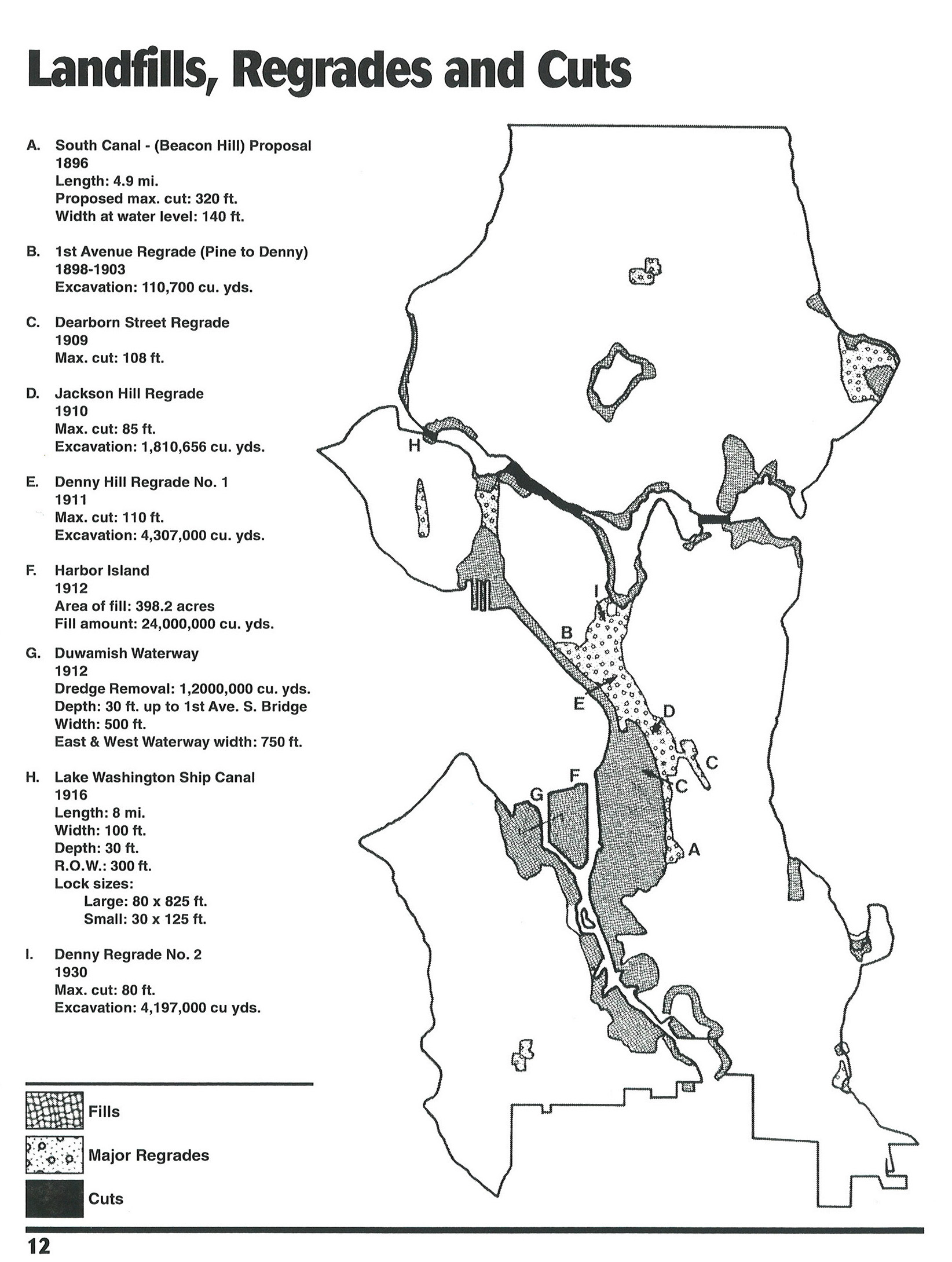
A quick one to show a map that captures the essence of the story of Seattle – this 1996 “Map of landfills, regrades, and cuts” outlines significant changes to the landscape of the city over the formative decades from 1896 to 1930. The source is the Seattle Municipal Archives, with a note of a source Seattle Engineering Department Digest, Special Commemorative Edition. A few interesting ones that aren’t labelled, such as the northernmost ‘Regrade’ which aligns in the vicinity of Northgate Mall and the wetlands around North Seattle College in the Thornton Creek drainage, and what I assume is also filling of the wetlands in the middle of Magnolia (just below the letter H). Also, while I get that there was some manipulation of Green Lake, I don’t think it’d be technically correct to refer to that as a fill, at least in the traditional sense of ‘making land’. It’s interesting to see these all captured in one figure. The impacts, of course, are well known.


